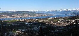
ਜ਼ੁਰਿਕ ਝੀਲ
| ਇਹ ਲੇਖ ਅਧਾਰ ਹੈ। ਤੁਸੀਂ ਇਸਨੂੰ ਵਧਾਕੇ ਵਿਕੀਪੀਡੀਆ ਦੀ ਮੱਦਦ ਕਰ ਸਕਦੇ ਹੋ। |
| ਜ਼ੁਰਿਕ ਝੀਲ Zürichsee | |
|---|---|
 | |
 | |
| ਗੁਣਕ | 47°15′N 8°41′E / 47.250°N 8.683°E |
| Primary inflows | Linth (Linthkanal) |
| Primary outflows | Limmat |
| Catchment area | 1,829 km2 (706 sq mi) |
| Basin countries | ਸਵਿਟਜਰਲੈਂਡ |
| ਵੱਧ ਤੋਂ ਵੱਧ ਲੰਬਾਈ | 40 kilometres (25 miles) |
| ਵੱਧ ਤੋਂ ਵੱਧ ਚੌੜਾਈ | 3 kilometres (2 miles) |
| Surface area | 88.66 square kilometres (34.23 square miles) |
| ਔਸਤ ਡੂੰਘਾਈ | 49 metres (161 feet) |
| ਵੱਧ ਤੋਂ ਵੱਧ ਡੂੰਘਾਈ | 143 metres (469 feet) |
| Water volume | 3.9 km3 (0.94 cu mi) |
| Residence time | 440 ਦਿਨ |
| Surface elevation | 406 m (1,332 ft) |
| Frozen | 1929, 1962/1963 (last) |
| Islands | Lützelau, Ufenau |
| Sections/sub-basins | Obersee |
| Settlements | see list |
ਜ਼ੁਰਿਕ ਝੀਲ (ਸਵਿਸ ਜਰਮਨ/ਅਲੇਮੈਨਿਕ: ਜ਼ੁਰਸੀ; ਜਰਮਨ: Zürichsee)[1] ਸਵਿਟਜਰਲੈਂਡ ਵਿੱਚ ਇੱਕ ਝੀਲ ਹੈ।
ਹਵਾਲੇ[ਸੋਧੋ]
- ↑ "National Map 1:50 000" (Map). Zürichsee (2011 ed.). 1:50 000. "National Map 1:50'000, 78 sheets and 25 composites". Bern, Switzerland: Swiss Federal Office of Topography, swisstopo. 16 January 2014. § "5011 Zürichsee - Zug". ISBN 978-3-302-05011-9. Retrieved 2014-12-01.
{{cite map}}: Unknown parameter|mapurl=ignored (|map-url=suggested) (help)
ਬਾਹਰੀ ਲਿੰਕ[ਸੋਧੋ]
ਵਿਕੀਮੀਡੀਆ ਕਾਮਨਜ਼ ਉੱਤੇ ਜ਼ੁਰਿਕ ਝੀਲ ਨਾਲ ਸਬੰਧਤ ਮੀਡੀਆ ਹੈ।
ਵਿਕੀਮੀਡੀਆ ਕਾਮਨਜ਼ ਉੱਤੇ Obersee (Zürichsee) ਨਾਲ ਸਬੰਧਤ ਮੀਡੀਆ ਹੈ।
- Zürichsee Schifffahrtsgesellschaft—Boat schedules, mainly non-English.
- Zürichsee-Fähre Horgen-Meilen—Ferry schedules, in German.
- Waterlevels Lake Zürich at ਜ਼ਿਊਰਿਖ
