
ਤਸਵੀਰ:ਫ਼੍ਰਾਂਸ ਦੇ ਖੇਤਰ.png

ਇਸ ਝਾਤ ਦਾ ਅਕਾਰ: 648 × 599 ਪਿਕਸਲ. ਹੋਰ ਰੈਜ਼ੋਲਿਊਸ਼ਨਜ਼: 260 × 240 ਪਿਕਸਲ | 519 × 480 ਪਿਕਸਲ | 831 × 768 ਪਿਕਸਲ | 1,108 × 1,024 ਪਿਕਸਲ | 2,215 × 2,048 ਪਿਕਸਲ.
ਅਸਲ ਫ਼ਾਈਲ (2,215 × 2,048 ਪਿਕਸਲ, ਫ਼ਾਈਲ ਅਕਾਰ: 761 KB, MIME ਕਿਸਮ: image/png)
 |
This file have no license. All files must have a license and unless a license is added, the file should be deleted. Please remove this template and add a template or nominate the file for deletion if it is not possible to add a license.
If you are the copyright holder please add a license for example {{Cc-by-sa-4.0}} + {{own}} to indicate that you are the photographer/creator. If the file is non-free and you think fair use will apply please add {{Non-free fair use}} |
ਵੇਰਵਾ[ਸੋਧੋ]
| Description |
| ||
|---|---|---|---|
| Source |
No source specified. Please edit this file description and provide a source. | ||
| Date | |||
| Author |
| ||
| Permission (Reusing this file) |
See below.
|
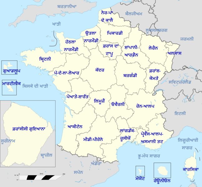
ਫ਼੍ਰਾਂਸ ਦੇ ੨੭ ਖੇਤਰਾਂ ਦਾ ਨਕਸ਼ਾ।
ਫ਼ਾਈਲ ਦਾ ਅਤੀਤ
ਤਾਰੀਖ/ਸਮੇਂ ’ਤੇ ਕਲਿੱਕ ਕਰੋ ਤਾਂ ਉਸ ਸਮੇਂ ਦੀ ਫਾਈਲ ਪੇਸ਼ ਹੋ ਜਾਵੇਗੀ।
| ਮਿਤੀ/ਸਮਾਂ | ਨਮੂਨਾ | ਨਾਪ | ਵਰਤੋਂਕਾਰ | ਟਿੱਪਣੀ | |
|---|---|---|---|---|---|
| ਮੌਜੂਦਾ | 11:14, 30 ਸਤੰਬਰ 2012 | | 2,215 × 2,048 (761 KB) | Babanwalia (ਗੱਲ-ਬਾਤ | ਯੋਗਦਾਨ) | ਫ਼੍ਰਾਂਸ ਦੇ ੨੭ ਖੇਤਰਾਂ ਦਾ ਨਕਸ਼ਾ। |
ਤੁਸੀਂ ਇਸ ਫ਼ਾਈਲ ਉੱਤੇ ਨਹੀਂ ਲਿਖ ਸਕਦੇ।
ਫ਼ਾਈਲ ਦੀ ਵਰਤੋਂ
ਇਹ ਫਾਈਲ ਹੇਠਾਂ ਦਿੱਤਾ ਸਫ਼ਾ ਵਰਤਦਾ ਹੈ: