
ਤਸਵੀਰ:Georgia location map.svg

Size of this PNG preview of this SVG file: 800 × 426 ਪਿਕਸਲ. ਹੋਰ ਰੈਜ਼ੋਲਿਊਸ਼ਨਜ਼: 320 × 170 ਪਿਕਸਲ | 640 × 341 ਪਿਕਸਲ | 1,024 × 545 ਪਿਕਸਲ | 1,280 × 681 ਪਿਕਸਲ | 2,560 × 1,363 ਪਿਕਸਲ | 1,715 × 913 ਪਿਕਸਲ.
ਅਸਲ ਫ਼ਾਈਲ (SVG ਫ਼ਾਈਲ, ਆਮ ਤੌਰ ’ਤੇ 1,715 × 913 ਪਿਕਸਲ, ਫ਼ਾਈਲ ਦਾ ਅਕਾਰ: 141 KB)
ਸਾਰ
| ਵੇਰਵਾ |
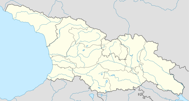
Deutsch: Positionskarte von Georgien
Quadratische Plattkarte, N-S-Streckung 135 %. Geographische Begrenzung der Karte:
English: Location map of Georgia
Equirectangular projection, N/S stretching 135 %. Geographic limits of the map:
|
| ਮਿਤੀ | |
| ਸਰੋਤ |
ਆਪਣਾ ਕੰਮ, using
|
| ਲਿਖਾਰੀ | NordNordWest |
| ਇਜਾਜ਼ਤ (ਇਸ ਫ਼ਾਈਲ ਦੀ ਮੁੜਵਰਤੋਂ ਕਰੋ) |
I, the copyright holder of this work, hereby publish it under the following license: ਇਸ ਫ਼ਾਈਲ ਦਾ ਲਸੰਸ ਕ੍ਰਿਏਟਿਵ ਕਾਮਨਜ਼ ਐਟ੍ਰੀਬਿਊਸ਼ਨ-ਸ਼ੇਅਰ ਅਲਾਈਕ 3.0 ਅਨਪੋਰਟੇਡ ਹੈ।
|
| Other versions |
|


ਫ਼ਾਈਲ ਦਾ ਅਤੀਤ
ਤਾਰੀਖ/ਸਮੇਂ ’ਤੇ ਕਲਿੱਕ ਕਰੋ ਤਾਂ ਉਸ ਸਮੇਂ ਦੀ ਫਾਈਲ ਪੇਸ਼ ਹੋ ਜਾਵੇਗੀ।
| ਮਿਤੀ/ਸਮਾਂ | ਨਮੂਨਾ | ਨਾਪ | ਵਰਤੋਂਕਾਰ | ਟਿੱਪਣੀ | |
|---|---|---|---|---|---|
| ਮੌਜੂਦਾ | 10:13, 28 ਅਕਤੂਬਰ 2018 | | 1,715 × 913 (141 KB) | NordNordWest | Reverted to version as of 11:58, 25 May 2013 (UTC), COM:OVERWRITE |
| 09:14, 28 ਅਕਤੂਬਰ 2018 |  | 1,715 × 913 (147 KB) | Lamensi | De facto independence | |
| 11:58, 25 ਮਈ 2013 |  | 1,715 × 913 (141 KB) | NordNordWest | Reverted to version as of 16:47, 24 July 2011, COM:OVERWRITE, too important to change without discussion | |
| 11:58, 25 ਮਈ 2013 |  | 1,715 × 913 (141 KB) | NordNordWest | Reverted to version as of 16:47, 24 July 2011, COM:OVERWRITE, too important to change without discussion | |
| 22:49, 24 ਮਈ 2013 |  | 1,715 × 913 (149 KB) | Giorgi Balakhadze | South Ossetian Autonomous Region was revoked on December 10, 1990 by the Supreme Soviet of the Georgian SSR. So it's not correct to show it in modern maps. [http://en.wikipedia.org/wiki/South_Ossetian_Autonomous_Oblast] | |
| 16:47, 24 ਜੁਲਾਈ 2011 |  | 1,715 × 913 (141 KB) | NordNordWest | corr | |
| 08:31, 10 ਸਤੰਬਰ 2009 |  | 1,716 × 913 (270 KB) | NordNordWest | ||
| 20:46, 9 ਸਤੰਬਰ 2009 |  | 1,716 × 879 (271 KB) | NordNordWest | =={{int:filedesc}}== {{Information |Description= {{de|Positionskarte von Georgien}} Quadratische Plattkarte, N-S-Streckung 130 %. Geographische Begrenzung der Karte: * N: 43.7° N * S: 40.9° N * W: 39.8° O * O: 46.9° O {{en|Location ma |
ਫ਼ਾਈਲ ਦੀ ਵਰਤੋਂ
ਇਹ ਫਾਈਲ ਹੇਠਾਂ ਦਿੱਤਾ ਸਫ਼ਾ ਵਰਤਦਾ ਹੈ:
ਫ਼ਾਈਲ ਦੀ ਵਿਆਪਕ ਵਰਤੋਂ
ਇਸ ਫ਼ਾਈਲ ਨੂੰ ਹੋਰ ਹੇਠ ਲਿਖੇ ਵਿਕੀ ਵਰਤਦੇ ਹਨ:
- af.wikipedia.org ਉੱਤੇ ਵਰਤੋਂ
- an.wikipedia.org ਉੱਤੇ ਵਰਤੋਂ
- ast.wikipedia.org ਉੱਤੇ ਵਰਤੋਂ
- av.wikipedia.org ਉੱਤੇ ਵਰਤੋਂ
- azb.wikipedia.org ਉੱਤੇ ਵਰਤੋਂ
- az.wikipedia.org ਉੱਤੇ ਵਰਤੋਂ
- Qaqra
- Faxralı
- Dmanisi
- Kəpənəkçi (Bolnisi)
- Sadaxlı
- Kəpənəkçi (Sarvan)
- Saraçlı (Borçalı)
- Qızılhacılı (Marneuli)
- İmirhəsən
- Yırğançay
- Qoçulu (Borçalı)
- Aşağı Qarabulaq
- Yuxarı Qarabulaq
- Arıxlı
- Rustavi
- Səfərli (Başkeçid)
- Aşağı Oruzman
- Soğanlıq
- Marabda
- Söyüdlü (Başkeçid)
- Qaracalar (Qarayazı)
- Salamməlik
- Saqareco
- Məmişlər (Başkeçid)
- Tbilisi Azərbaycan Teatrı
- Təkəli (Marneuli)
- Ağaməmmədli (Marneuli)
- Axlılələ
ਇਸ ਫ਼ਾਈਲ ਦੀ ਹੋਰ ਵਿਆਪਕ ਵਰਤੋਂ ਵੇਖੋ।