
ਤਸਵੀਰ:Haiti deforestation.jpg
ਇਸ ਝਾਤ ਦਾ ਅਕਾਰ: 800 × 600 ਪਿਕਸਲ. ਹੋਰ ਰੈਜ਼ੋਲਿਊਸ਼ਨਜ਼: 320 × 240 ਪਿਕਸਲ | 640 × 480 ਪਿਕਸਲ | 1,024 × 768 ਪਿਕਸਲ | 1,280 × 960 ਪਿਕਸਲ | 2,560 × 1,920 ਪਿਕਸਲ.
ਅਸਲ ਫ਼ਾਈਲ (2,560 × 1,920 ਪਿਕਸਲ, ਫ਼ਾਈਲ ਅਕਾਰ: 1.48 MB, MIME ਕਿਸਮ: image/jpeg)
| ਵੇਰਵਾ |
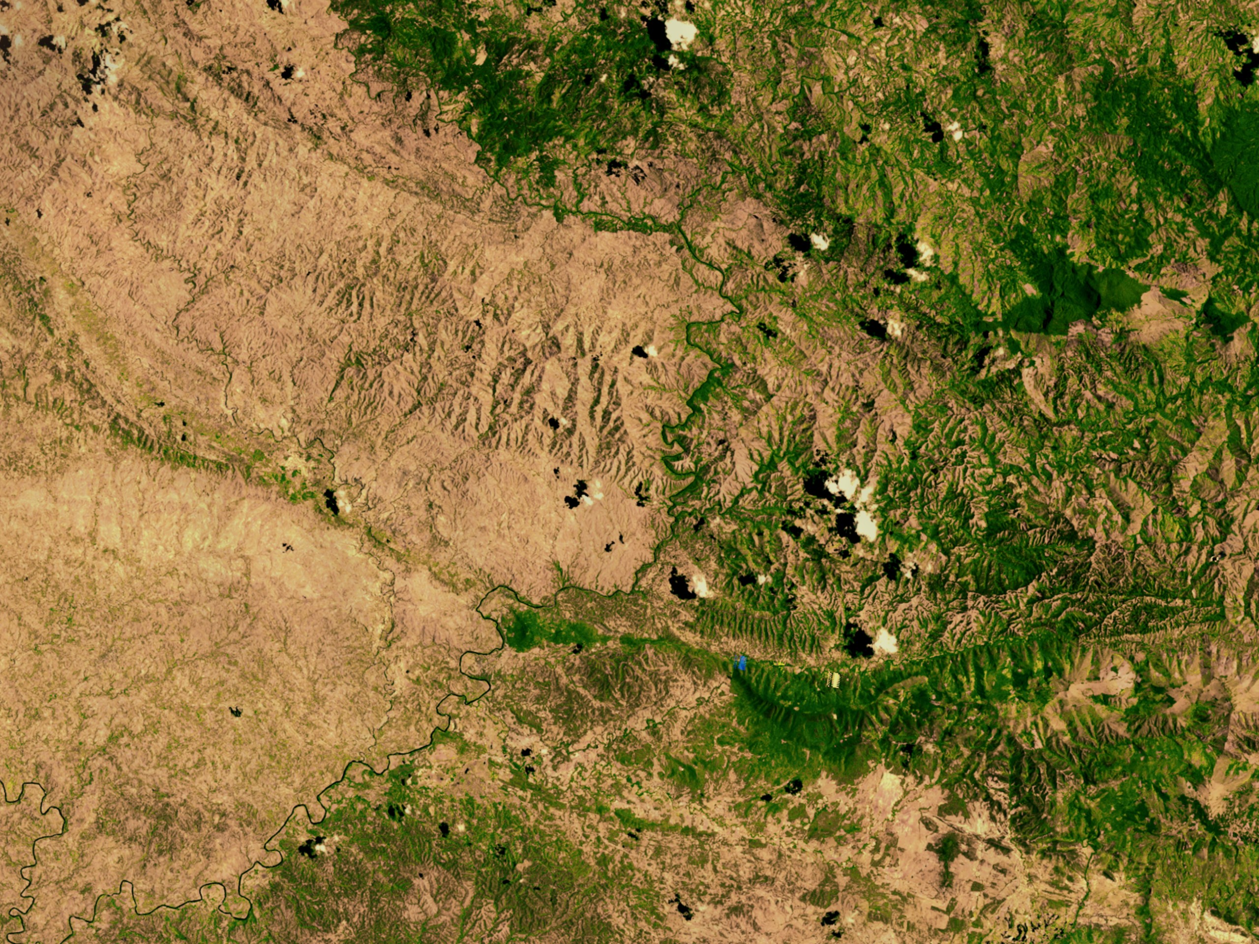
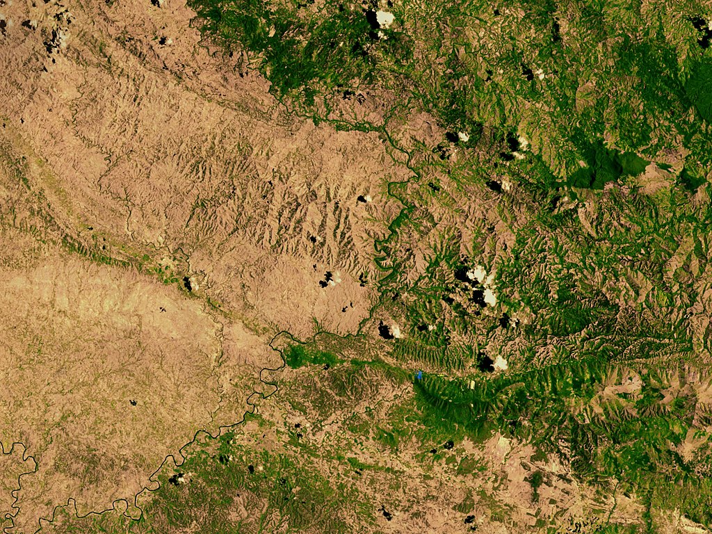
English: Satellite image showing deforestation in Haiti, Haiti-Centre. This image depicts the border between Haiti (left) and the Dominican Republic (right). |
|||||
| ਮਿਤੀ | ||||||
| ਸਰੋਤ | http://svs.gsfc.nasa.gov/vis/a000000/a002600/a002640/ | |||||
| ਲਿਖਾਰੀ | NASA | |||||
| ਇਜਾਜ਼ਤ (ਇਸ ਫ਼ਾਈਲ ਦੀ ਮੁੜਵਰਤੋਂ ਕਰੋ) |
|

| Object location | | View this and other nearby images on: OpenStreetMap |
|---|
ਫ਼ਾਈਲ ਦਾ ਅਤੀਤ
ਤਾਰੀਖ/ਸਮੇਂ ’ਤੇ ਕਲਿੱਕ ਕਰੋ ਤਾਂ ਉਸ ਸਮੇਂ ਦੀ ਫਾਈਲ ਪੇਸ਼ ਹੋ ਜਾਵੇਗੀ।
| ਮਿਤੀ/ਸਮਾਂ | ਨਮੂਨਾ | ਨਾਪ | ਵਰਤੋਂਕਾਰ | ਟਿੱਪਣੀ | |
|---|---|---|---|---|---|
| ਮੌਜੂਦਾ | 02:54, 10 ਮਾਰਚ 2008 | | 2,560 × 1,920 (1.48 MB) | Calliopejen | {{Information |Description=Satellite image showing deforestation in Haiti. This image depicts the border between Haiti (left) and the Dominican Republic (right). |Source=http://svs.gsfc.nasa.gov/vis/a000000/a002600/a002640/ |Date=2002-09-25 |Author=NASA | |
ਫ਼ਾਈਲ ਦੀ ਵਰਤੋਂ
ਇਹ ਫਾਈਲ ਹੇਠਾਂ ਦਿੱਤਾ ਸਫ਼ਾ ਵਰਤਦਾ ਹੈ:
ਫ਼ਾਈਲ ਦੀ ਵਿਆਪਕ ਵਰਤੋਂ
ਇਸ ਫ਼ਾਈਲ ਨੂੰ ਹੋਰ ਹੇਠ ਲਿਖੇ ਵਿਕੀ ਵਰਤਦੇ ਹਨ:
- af.wikipedia.org ਉੱਤੇ ਵਰਤੋਂ
- ar.wikipedia.org ਉੱਤੇ ਵਰਤੋਂ
- ast.wikipedia.org ਉੱਤੇ ਵਰਤੋਂ
- az.wikipedia.org ਉੱਤੇ ਵਰਤੋਂ
- be.wikipedia.org ਉੱਤੇ ਵਰਤੋਂ
- cs.wikipedia.org ਉੱਤੇ ਵਰਤੋਂ
- de.wikipedia.org ਉੱਤੇ ਵਰਤੋਂ
- de.wiktionary.org ਉੱਤੇ ਵਰਤੋਂ
- en.wikipedia.org ਉੱਤੇ ਵਰਤੋਂ
- en.wikinews.org ਉੱਤੇ ਵਰਤੋਂ
- es.wikipedia.org ਉੱਤੇ ਵਰਤੋਂ
- eu.wikipedia.org ਉੱਤੇ ਵਰਤੋਂ
- fa.wikipedia.org ਉੱਤੇ ਵਰਤੋਂ
- fr.wikipedia.org ਉੱਤੇ ਵਰਤੋਂ
- fr.wikiversity.org ਉੱਤੇ ਵਰਤੋਂ
- ht.wikipedia.org ਉੱਤੇ ਵਰਤੋਂ
- ig.wikipedia.org ਉੱਤੇ ਵਰਤੋਂ
- kk.wikipedia.org ਉੱਤੇ ਵਰਤੋਂ
- la.wikipedia.org ਉੱਤੇ ਵਰਤੋਂ
- mt.wikipedia.org ਉੱਤੇ ਵਰਤੋਂ
- nn.wikipedia.org ਉੱਤੇ ਵਰਤੋਂ
- no.wikipedia.org ਉੱਤੇ ਵਰਤੋਂ
- oc.wikipedia.org ਉੱਤੇ ਵਰਤੋਂ
- pl.wikipedia.org ਉੱਤੇ ਵਰਤੋਂ
- pt.wikipedia.org ਉੱਤੇ ਵਰਤੋਂ
- pt.wikibooks.org ਉੱਤੇ ਵਰਤੋਂ
- ru.wikipedia.org ਉੱਤੇ ਵਰਤੋਂ
- te.wikipedia.org ਉੱਤੇ ਵਰਤੋਂ
- uk.wikipedia.org ਉੱਤੇ ਵਰਤੋਂ
ਇਸ ਫ਼ਾਈਲ ਦੀ ਹੋਰ ਵਿਆਪਕ ਵਰਤੋਂ ਵੇਖੋ।