
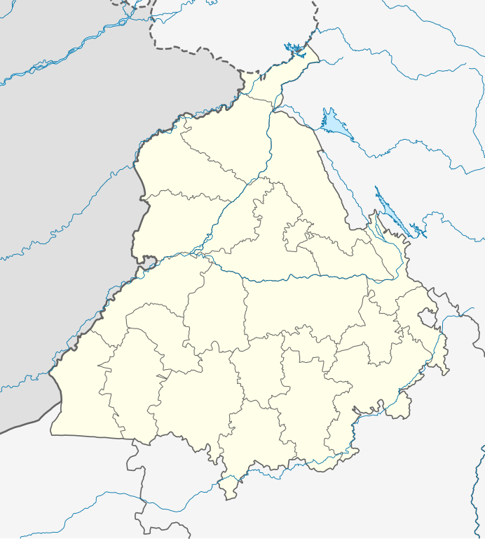
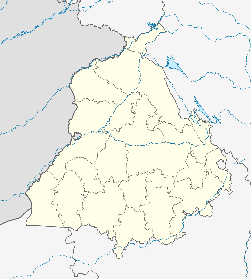
ਤਸਵੀਰ:India Punjab location map.svg

ਅਸਲ ਫ਼ਾਈਲ (SVG ਫ਼ਾਈਲ, ਆਮ ਤੌਰ ’ਤੇ 979 × 1,086 ਪਿਕਸਲ, ਫ਼ਾਈਲ ਦਾ ਅਕਾਰ: 311 KB)
ਸਾਰ
| ਵੇਰਵਾ |
Quadratische Plattkarte, N-S-Streckung 117 %. Geographische Begrenzung der Karte:
Equirectangular projection, N/S stretching 117 %. Geographic limits of the map:
|
|
| ਮਿਤੀ | ||
| ਸਰੋਤ |
ਆਪਣਾ ਕੰਮ, using
|
|
| ਲਿਖਾਰੀ | NordNordWest | |
| ਇਜਾਜ਼ਤ (ਇਸ ਫ਼ਾਈਲ ਦੀ ਮੁੜਵਰਤੋਂ ਕਰੋ) |
This file is licensed under the Creative Commons Attribution-Share Alike 3.0 Germany license.
 This file is licensed under the Creative Commons Attribution-Share Alike 3.0 Germany license.
|


|
This map has been made or improved in the German Kartenwerkstatt (Map Lab). You can propose maps to improve as well.
|
ਫ਼ਾਈਲ ਦਾ ਅਤੀਤ
ਤਾਰੀਖ/ਸਮੇਂ ’ਤੇ ਕਲਿੱਕ ਕਰੋ ਤਾਂ ਉਸ ਸਮੇਂ ਦੀ ਫਾਈਲ ਪੇਸ਼ ਹੋ ਜਾਵੇਗੀ।
| ਮਿਤੀ/ਸਮਾਂ | ਨਮੂਨਾ | ਨਾਪ | ਵਰਤੋਂਕਾਰ | ਟਿੱਪਣੀ | |
|---|---|---|---|---|---|
| ਮੌਜੂਦਾ | 04:19, 19 ਅਗਸਤ 2022 | | 979 × 1,086 (311 KB) | C1MM | Fixed Ludhiana district |
| 04:03, 19 ਅਗਸਤ 2022 |  | 979 × 1,086 (312 KB) | C1MM | Resized to original size | |
| 03:57, 19 ਅਗਸਤ 2022 |  | 951 × 898 (324 KB) | C1MM | Added Malerkotla district, fixed rivers and disputed boundaries for Jammu and Kashmir | |
| 03:23, 15 ਜਨਵਰੀ 2021 |  | 1,049 × 1,161 (114 KB) | C1MM | Added Tan Taran district | |
| 18:11, 24 ਅਕਤੂਬਰ 2020 |  | 1,049 × 1,161 (110 KB) | C1MM | Updated districts | |
| 17:41, 4 ਮਈ 2012 |  | 1,049 × 1,161 (107 KB) | NordNordWest | upd | |
| 20:24, 19 ਮਈ 2010 |  | 1,049 × 1,161 (104 KB) | NordNordWest | c | |
| 20:11, 19 ਮਈ 2010 |  | 1,049 × 1,161 (105 KB) | NordNordWest | =={{int:filedesc}}== {{Information |Description= {{de|Positionskarte von Punjab, Indien}} Quadratische Plattkarte, N-S-Streckung 117 %. Geographische Begrenzung der Karte: * N: 32.8° N * S: 29.3° N * W: 73.5° O * |
ਫ਼ਾਈਲ ਦੀ ਵਰਤੋਂ
More than 100 pages use this file. The following list shows the first 100 pages that use this file only. A full list is available.
- ਅਜਨਾਲਾ, ਭਾਰਤ
- ਅਜੀਤਗੜ੍ਹ
- ਅਬਾਦਗੜ੍ਹ, ਗੁਰਦਾਸਪੁਰ
- ਅਲੀਵਾਲ ਜੱਟਾਂ
- ਅਸਗਰੀਪੁਰ
- ਅੰਮ੍ਰਿਤਸਰ
- ਅੰਮ੍ਰਿਤਸਰ ਛਾਉਣੀ
- ਆਸਰਾਪੁਰ
- ਈਸੜਾ
- ਉਟਾਲਾਂ
- ਕਮਾਲਪੁਰ, ਭੁਲੱਥ
- ਕਰਤਾਰਪੁਰ, ਭਾਰਤ
- ਕਰੌਦੀਆਂ
- ਕੁਲਬੁਰਛਾਂ
- ਕੈਰੇ, ਪੰਜਾਬ
- ਕੋਟਲਾ ਨਿਹੰਗ ਖ਼ਾਨ
- ਕੋਠਾ ਗੁਰੂ
- ਖਰੜ
- ਖਾਨਪੁਰ (ਲੁਧਿਆਣਾ ਪੱਛਮ)
- ਖੇੜਾ ਦੋਨਾ
- ਖੇੜੀ ਸਾਹਿਬ
- ਗੁੰਮਟੀ ਕਲਾਂ
- ਗੱਗੜ ਮਾਜਰਾ
- ਘਲੋਟੀ
- ਘੁਰਾਲਾ
- ਘੁੱਦੂਵਾਲਾ, ਮਾਨਸਾ
- ਚਾਪੜਾ
- ਜਰਗ
- ਜਲ੍ਹਿਆਂਵਾਲਾ ਬਾਗ ਹੱਤਿਆਕਾਂਡ
- ਜ਼ੀਰਾ, ਪੰਜਾਬ
- ਜੋਧ ਸਿੰਘ ਵਾਲਾ
- ਜੌੜਕੀਆਂ
- ਜੰਡਾਲੀ
- ਜੰਡਿਆਲਾ ਗੁਰੂ
- ਝੁਨੀਰ
- ਡੱਲਾ, ਪੰਜਾਬ
- ਢਿੱਲਵਾਂ ਕਲਾਂ
- ਢੀਂਗੀ
- ਢੇਰ
- ਦਫ਼ਤਰੀਵਾਲਾ
- ਦਹਿੜੂ
- ਦੀਨੇਵਾਲ
- ਦੱਧਾਹੂਰ
- ਧਮੋਟ ਕਲਾਂ
- ਧਮੋਟ ਖੁਰਦ
- ਨਾਭਾ
- ਨਿਊ ਚੰਡੀਗੜ੍ਹ, ਪੰਜਾਬ
- ਨਿਜ਼ਾਮਪੁਰ, ਲੁਧਿਆਣਾ
- ਪਟਿਆਲਾ ਹਵਾਈ ਅੱਡਾ
- ਪਠਾਨਕੋਟ
- ਪਰਿਵਾਰ ਵਿਛੋੜਾ
- ਪੁਲ ਕੰਜਰੀ
- ਫਤਿਹਗੜ੍ਹ ਛੰਨਾ, ਸੰਗਰੂਰ
- ਫਤਿਹਾਬਾਦ, ਪੰਜਾਬ
- ਫ਼ਤਿਹ ਬੁਰਜ
- ਫ਼ਿਰੋਜ਼ਪੁਰ
- ਫੱਤਾ ਮਾਲੋਕਾ
- ਬਠਿੰਡਾ ਹਵਾਈ ਅੱਡਾ
- ਬਰੇਟਾ
- ਬਾਸੀ ਅਰਖ
- ਬਿਆਸ ਸ਼ਹਿਰ
- ਬਿਰਧਨੋ
- ਬੁਰਜ ਭਲਾਈਕੇ
- ਬੰਗਾ, ਭਾਰਤ
- ਬੱਧਨੀ ਕਲਾਂ
- ਬੱਲਰਾਂ
- ਭਗਵਾਨਗੜ੍ਹ
- ਭਰੋਵਾਲ
- ਭਲਾਈਕੇ
- ਭਾਈ ਰੂਪਾ
- ਮਜੀਠਾ
- ਮਲੌਦ
- ਮਾਨਸਾ, ਪੰਜਾਬ
- ਮੂਸਾ, ਪੰਜਾਬ
- ਮੇਹਟੀਆਣਾ
- ਮੰਢਿਆਲਾ
- ਰਾਏਪੁਰ ਚੋਬਦਾਰਾਂ
- ਰਾਜਾਤਾਲ
- ਰਾਜਾਸਾਂਸੀ
- ਰਾਜਿਆਣਾ
- ਰਾਮਦਾਸ
- ਰੂਪਨਗਰ
- ਲਖਮੀਰ ਵਾਲਾ
- ਲਾਂਦੜਾ
- ਲਾਪਰਾਂ
- ਲਿਬੜਾ
- ਲੰਗੇਰੀ
- ਲੰਢੇ ਕੇ
- ਵਿਰਾਸਤ-ਏ-ਖ਼ਾਲਸਾ
- ਸਮਾਲਸਰ
- ਸਰਦੂਲਗੜ੍ਹ
- ਸਰਾਭਾ
- ਸਲਾਣਾ ਜੀਵਨ ਸਿੰਘ ਵਾਲਾ
- ਸਾਦਿਕ
- ਸਿਹੌੜਾ
- ਹਰਿਮੰਦਰ ਸਾਹਿਬ
- ਹਿਮਾਯੂੰਪੁਰਾ
- ਫਰਮਾ:ਸਥਿਤੀ ਨਕਸ਼ਾ ਭਾਰਤ ਪੰਜਾਬ
- ਮੌਡਿਊਲ:Location map/data/India Punjab
- ਮੌਡਿਊਲ:Location map/data/India Punjab/doc
ਇਸ ਫ਼ਾਈਲ ਨਾਲ਼ ਜੋੜਦੇ ਹੋਰ ਲਿੰਕ ਵੇਖੋ।
ਫ਼ਾਈਲ ਦੀ ਵਿਆਪਕ ਵਰਤੋਂ
ਇਸ ਫ਼ਾਈਲ ਨੂੰ ਹੋਰ ਹੇਠ ਲਿਖੇ ਵਿਕੀ ਵਰਤਦੇ ਹਨ:
- ar.wikipedia.org ਉੱਤੇ ਵਰਤੋਂ
- as.wikipedia.org ਉੱਤੇ ਵਰਤੋਂ
- azb.wikipedia.org ਉੱਤੇ ਵਰਤੋਂ
- علیپور-۲
- علیپور-۱
- علی چاک
- علادینپور
- علیخل، جالاندر
- فول ماکاوری
- فیالی (هیندوستان)
- فاروالا, جالاندهار
- فارالا
- فانقوتا
- فامبرا
- فالپوتا
- ساروپوال
- ساروپوال, سولطانپور لودهی
- سارتی, قورداسپور
- سارنانا
- سارینه, لودهیانا
- سارینه, جالاندهار
- سارهالی
- سارهالی, جالاندهار
- سارهال کازیان
- سارهال موندی
- سارقوندی
- سارانقوال
- سارانقرا
- سارای خاس
- سارای خام
- سارای جاتان
- ساپرور
- مدا, پنجاب
- مازاری, اسبیاس ناقار
- مازارا ناو آباد
- مازارا خورد
- مازارا کالان
- سانورا
- ماوای, جالاندهار
- ماولی, فاقوارا
- ماوجیا
- ماو, پنجاب
- ماتوی, پنجاب
- سانقرای
- سانقرا, سولطانپور لودهی
- سانقووال
- سانقوجلا
- سانقول
- سانقرا (کند)
ਇਸ ਫ਼ਾਈਲ ਦੀ ਹੋਰ ਵਿਆਪਕ ਵਰਤੋਂ ਵੇਖੋ।