
ਤਸਵੀਰ:Map OC-Oceania.PNG
ਇਸ ਤੋਂ ਵੱਡੀ ਤਸਵੀਰ ਮੌਜੂਦ ਨਹੀਂ ਹੈ।
Map_OC-Oceania.PNG (500 × 500 ਪਿਕਸਲ, ਫ਼ਾਈਲ ਅਕਾਰ: 16 KB, MIME ਕਿਸਮ: image/png)
ਸਾਰ
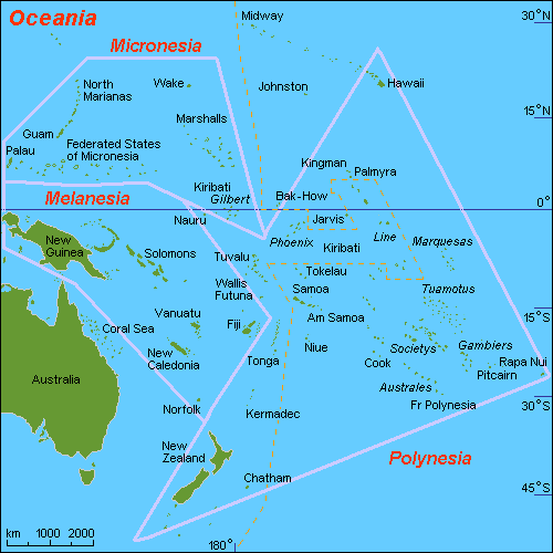
| ਵੇਰਵਾ |
English: Map (rough) regions of Oceania, own work composed from various mapreferences |
| ਮਿਤੀ | |
| ਸਰੋਤ | ਆਪਣਾ ਕੰਮ |
| ਲਿਖਾਰੀ | Hobe / Holger Behr |
ਲਸੰਸ
| I, the copyright holder of this work, release this work into the public domain. This applies worldwide. In some countries this may not be legally possible; if so: I grant anyone the right to use this work for any purpose, without any conditions, unless such conditions are required by law. |
ਫ਼ਾਈਲ ਦਾ ਅਤੀਤ
ਤਾਰੀਖ/ਸਮੇਂ ’ਤੇ ਕਲਿੱਕ ਕਰੋ ਤਾਂ ਉਸ ਸਮੇਂ ਦੀ ਫਾਈਲ ਪੇਸ਼ ਹੋ ਜਾਵੇਗੀ।
| ਮਿਤੀ/ਸਮਾਂ | ਨਮੂਨਾ | ਨਾਪ | ਵਰਤੋਂਕਾਰ | ਟਿੱਪਣੀ | |
|---|---|---|---|---|---|
| ਮੌਜੂਦਾ | 18:18, 28 ਸਤੰਬਰ 2007 | | 500 × 500 (16 KB) | Hobe | {{Information |Description=map of regions of Oceania |Source=self-made, composed from various mapreferences |Date=2007-09-19 |Author= Hobe Category:Maps of Oceania }} |
ਫ਼ਾਈਲ ਦੀ ਵਰਤੋਂ
ਇਹ ਫਾਈਲ ਹੇਠਾਂ ਦਿੱਤਾ ਸਫ਼ਾ ਵਰਤਦਾ ਹੈ:
ਫ਼ਾਈਲ ਦੀ ਵਿਆਪਕ ਵਰਤੋਂ
ਇਸ ਫ਼ਾਈਲ ਨੂੰ ਹੋਰ ਹੇਠ ਲਿਖੇ ਵਿਕੀ ਵਰਤਦੇ ਹਨ:
- af.wikipedia.org ਉੱਤੇ ਵਰਤੋਂ
- als.wikipedia.org ਉੱਤੇ ਵਰਤੋਂ
- ca.wikipedia.org ਉੱਤੇ ਵਰਤੋਂ
- de.wikipedia.org ਉੱਤੇ ਵਰਤੋਂ
- en.wikipedia.org ਉੱਤੇ ਵਰਤੋਂ
- eo.wikipedia.org ਉੱਤੇ ਵਰਤੋਂ
- es.wikibooks.org ਉੱਤੇ ਵਰਤੋਂ
- frr.wikipedia.org ਉੱਤੇ ਵਰਤੋਂ
- incubator.wikimedia.org ਉੱਤੇ ਵਰਤੋਂ
- la.wikipedia.org ਉੱਤੇ ਵਰਤੋਂ
- mi.wikipedia.org ਉੱਤੇ ਵਰਤੋਂ
- no.wikipedia.org ਉੱਤੇ ਵਰਤੋਂ
- or.wikipedia.org ਉੱਤੇ ਵਰਤੋਂ
- pnb.wikipedia.org ਉੱਤੇ ਵਰਤੋਂ
- ru.wikipedia.org ਉੱਤੇ ਵਰਤੋਂ
- sv.wikipedia.org ਉੱਤੇ ਵਰਤੋਂ
- uk.wikipedia.org ਉੱਤੇ ਵਰਤੋਂ
- www.wikidata.org ਉੱਤੇ ਵਰਤੋਂ