ਸੇਂਟ ਲਾਰੰਸ ਦਰਿਆ: ਰੀਵਿਜ਼ਨਾਂ ਵਿਚ ਫ਼ਰਕ
ਸਮੱਗਰੀ ਮਿਟਾਈ ਸਮੱਗਰੀ ਜੋੜੀ
Satdeepbot (ਗੱਲ-ਬਾਤ | ਯੋਗਦਾਨ) ਛੋ clean up using AWB |
Satdeepbot (ਗੱਲ-ਬਾਤ | ਯੋਗਦਾਨ) |
||
| ਲਾਈਨ 1: | ਲਾਈਨ 1: | ||
{{Geobox|ਦਰਿਆ|category_hide=yes |
{{Geobox|ਦਰਿਆ|category_hide=yes |
||
| name |
| name = ਸੇਂਟ ਲਾਰੰਸ ਦਰਿਆ<br/>St. Lawrence River |
||
| other_name |
| other_name = ''Fleuve Saint-Laurent'' |
||
| other_name1 |
| other_name1 = |
||
| other_name2 |
| other_name2 = |
||
| etymology |
| etymology = |
||
| map |
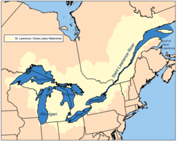
| map = Grlakes lawrence map.png |
||
| map_caption |
| map_caption = ਸੇਂਟ ਲਾਰੰਸ/ਮਹਾਨ ਝੀਲਾਂ ਦੇ ਜਲ-ਬੋਚੂ ਇਲਾਕੇ ਦਾ ਨਕਸ਼ਾ |
||
| country |
| country = ਕੈਨੇਡਾ |
||
| country1 |
| country1 = ਸੰਯੁਕਤ ਰਾਜ |
||
| state |
| state = ਓਂਟਾਰੀਓ |
||
| state1 |
| state1 = ਕੇਬੈਕ |
||
| state2 |
| state2 = ਨਿਊ ਯਾਰਕ |
||
| state_type |
| state_type = ਰਾਜ/ਸੂਬੇ |
||
| region |
| region = |
||
| length |
| length = 1197 |
||
| length_round |
| length_round = 0 |
||
| length_note |
| length_note = |
||
| watershed |
| watershed = 1344200 |
||
| watershed_round |
| watershed_round = -2 |
||
| watershed_note |
| watershed_note =<ref name=Atlas>Natural Resources Canada, Atlas of Canada - [http://atlas.nrcan.gc.ca/site/english/learningresources/facts/rivers.html Rivers]</ref> |
||
| discharge_location |
| discharge_location = ਸਗੂਨੇ ਦਰਿਆ ਹੇਠਾਂ |
||
| discharge |
| discharge = 16800 |
||
| discharge_round |
| discharge_round = -4 |
||
| discharge_note |
| discharge_note =<ref name="BenkeCushing2005">{{cite book|last1=Benke|first1=Arthur C.|last2=Cushing|first2=Colbert E.|title=Rivers of North America|url=http://books.google.com/books?id=faOU1wkiYFIC&pg=PA989|year=2005|publisher=Academic Press|isbn=978-0-12-088253-3|pages=989–990}}</ref> |
||
| discharge_max_note |
| discharge_max_note = |
||
| discharge_max |
| discharge_max = |
||
| discharge_min_note |
| discharge_min_note = |
||
| discharge_min |
| discharge_min = |
||
| discharge1_location |
| discharge1_location = |
||
| discharge1 |
| discharge1 = |
||
| source |
| source = ਓਂਟਾਰੀਓ ਝੀਲ |
||
| source_location |
| source_location = [[ਕਿੰਗਸਟਨ, ਓਂਟਾਰੀਓ]] / [[ਕੇਪ ਵਿਨਸੈਂਟ, ਨਿਊ ਯਾਰਕ]] |
||
| source_district |
| source_district = |
||
| source_state |
| source_state = |
||
| source_country |
| source_country = |
||
| source_elevation |
| source_elevation = 74.7 |
||
| source_lat_d |
| source_lat_d = 44 |
||
| source_lat_m |
| source_lat_m = 06 |
||
| source_lat_s |
| source_lat_s = |
||
| source_lat_NS |
| source_lat_NS = N |
||
| source_long_d |
| source_long_d = 76 |
||
| source_long_m |
| source_long_m = 24 |
||
| source_long_s |
| source_long_s = |
||
| source_long_EW |
| source_long_EW = W |
||
| mouth_name |
| mouth_name = [[ਸੇਂਟ ਲਾਰੰਸ ਦੀ ਖਾੜੀ]] / [[ਅੰਧ ਮਹਾਂਸਾਗਰ]] |
||
| mouth_location |
| mouth_location = |
||
| mouth_region |
| mouth_region = |
||
| mouth_state |
| mouth_state = ਕੇਬੈਕ |
||
| mouth_country |
| mouth_country = ਕੈਨੇਡਾ |
||
| mouth_elevation |
| mouth_elevation = 0 |
||
| mouth_lat_d |
| mouth_lat_d = 49 |
||
| mouth_lat_m |
| mouth_lat_m = 30 |
||
| mouth_lat_s |
| mouth_lat_s = |
||
| mouth_lat_NS |
| mouth_lat_NS = N |
||
| mouth_long_d |
| mouth_long_d = 64 |
||
| mouth_long_m |
| mouth_long_m = 30 |
||
| mouth_long_s |
| mouth_long_s = |
||
| mouth_long_EW |
| mouth_long_EW =W |
||
| tributary_left |
| tributary_left = |
||
| tributary_left1 |
| tributary_left1 = |
||
| tributary_left2 |
| tributary_left2 = |
||
| tributary_right |
| tributary_right = |
||
| tributary_right1 |
| tributary_right1 = |
||
| tributary_right2 |
| tributary_right2 = |
||
| image |
| image = Saint Lawrence seaway.jpg |
||
| image_size |
| image_size = |
||
| image_caption |
| image_caption = ਸਿਕੰਦਰੀਆ ਖਾੜੀ ਕੋਲ ਸੇਂਟ ਲਾਰੰਸ ਦਰਿਆ |
||
}} |
}} |
||
04:22, 17 ਸਤੰਬਰ 2020 ਦਾ ਦੁਹਰਾਅ
| ਸੇਂਟ ਲਾਰੰਸ ਦਰਿਆ St. Lawrence River | |
| Fleuve Saint-Laurent | |
ਸਿਕੰਦਰੀਆ ਖਾੜੀ ਕੋਲ ਸੇਂਟ ਲਾਰੰਸ ਦਰਿਆ
| |
| ਦੇਸ਼ | ਕੈਨੇਡਾ, ਸੰਯੁਕਤ ਰਾਜ |
|---|---|
| ਰਾਜ/ਸੂਬੇ | ਓਂਟਾਰੀਓ, ਕੇਬੈਕ, ਨਿਊ ਯਾਰਕ |
| ਸਰੋਤ | ਓਂਟਾਰੀਓ ਝੀਲ |
| - ਸਥਿਤੀ | ਕਿੰਗਸਟਨ, ਓਂਟਾਰੀਓ / ਕੇਪ ਵਿਨਸੈਂਟ, ਨਿਊ ਯਾਰਕ |
| - ਉਚਾਈ | 74.7 ਮੀਟਰ (245 ਫੁੱਟ) |
| - ਦਿਸ਼ਾ-ਰੇਖਾਵਾਂ | 44°06′N 76°24′W / 44.100°N 76.400°W |
| ਦਹਾਨਾ | ਸੇਂਟ ਲਾਰੰਸ ਦੀ ਖਾੜੀ / ਅੰਧ ਮਹਾਂਸਾਗਰ |
| - ਉਚਾਈ | 0 ਮੀਟਰ (0 ਫੁੱਟ) |
| - ਦਿਸ਼ਾ-ਰੇਖਾਵਾਂ | 49°30′N 64°30′W / 49.500°N 64.500°W |
| ਲੰਬਾਈ | 1,197 ਕਿਮੀ (744 ਮੀਲ) |
| ਬੇਟ | 13,44,200 ਕਿਮੀ੨ (5,19,000 ਵਰਗ ਮੀਲ) [1] |
| ਡਿਗਾਊ ਜਲ-ਮਾਤਰਾ | ਸਗੂਨੇ ਦਰਿਆ ਹੇਠਾਂ |
| - ਔਸਤ | 16,800 ਮੀਟਰ੩/ਸ (5,90,000 ਘਣ ਫੁੱਟ/ਸ) [2] |
ਸੇਂਟ ਲਾਰੰਸ ਦਰਿਆ (ਫ਼ਰਾਂਸੀਸੀ: fleuve Saint-Laurent; ਟਸਕਾਰੋਰਾ: Kahnawáʼkye;[3] ਮੋਹਾਕ: Kaniatarowanenneh, ਭਾਵ "ਵੱਡਾ ਜਲ-ਮਾਰਗ") ਇੱਕ ਵਿਸ਼ਾਲ ਦਰਿਆ ਹੈ ਜੋ ਉੱਤਰੀ ਅਮਰੀਕਾ ਦੇ ਮੱਧਵਰਤੀ ਅਕਸ਼ਾਂਸ਼ਾਂ ਵਿੱਚ ਦੱਖਣ-ਪੱਛਮ ਤੋਂ ਉੱਤਰ-ਪੂਰਬ ਵੱਲ ਵਗਦਾ ਹੈ ਅਤੇ ਜੋ ਮਹਾਨ ਝੀਲਾਂ ਨੂੰ ਅੰਧ ਮਹਾਂਸਾਗਰ ਨਾਲ਼ ਜੋੜਦਾ ਹੈ।
ਹਵਾਲੇ
- ↑ Natural Resources Canada, Atlas of Canada - Rivers
- ↑ Benke, Arthur C.; Cushing, Colbert E. (2005). Rivers of North America. Academic Press. pp. 989–990. ISBN 978-0-12-088253-3.
- ↑ Rudes, B. Tuscarora English Dictionary Toronto: University of Toronto Press, 1999
| ਇਹ ਲੇਖ ਅਧਾਰ ਹੈ। ਤੁਸੀਂ ਇਸਨੂੰ ਵਧਾਕੇ ਵਿਕੀਪੀਡੀਆ ਦੀ ਮੱਦਦ ਕਰ ਸਕਦੇ ਹੋ। |


