
ਤਸਵੀਰ:East Siberian Sea map.png

ਇਸ ਝਾਤ ਦਾ ਅਕਾਰ: 800 × 445 ਪਿਕਸਲ. ਹੋਰ ਰੈਜ਼ੋਲਿਊਸ਼ਨਜ਼: 320 × 178 ਪਿਕਸਲ | 640 × 356 ਪਿਕਸਲ | 1,192 × 663 ਪਿਕਸਲ.
ਅਸਲ ਫ਼ਾਈਲ (1,192 × 663 ਪਿਕਸਲ, ਫ਼ਾਈਲ ਅਕਾਰ: 116 KB, MIME ਕਿਸਮ: image/png)
| ਵੇਰਵਾ |
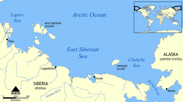
English: Map showing the location of the East Siberian Sea, part of the Arctic Ocean, located north of Siberia and between the Laptev Sea and Chukchi Sea.
Français : Carte de localisation de la mer de Sibérie orientale |
||||||||
| ਮਿਤੀ | |||||||||
| ਸਰੋਤ | ਆਪਣਾ ਕੰਮ | ||||||||
| ਲਿਖਾਰੀ | ਆਪਣਾ ਕੰਮ | ||||||||
| ਇਜਾਜ਼ਤ (ਇਸ ਫ਼ਾਈਲ ਦੀ ਮੁੜਵਰਤੋਂ ਕਰੋ) |
I, the copyright holder of this work, hereby publish it under the following license:
|
||||||||
| Other versions | Derivative works of this file: East Siberian Sea map hr.svg |

ਫ਼ਾਈਲ ਦਾ ਅਤੀਤ
ਤਾਰੀਖ/ਸਮੇਂ ’ਤੇ ਕਲਿੱਕ ਕਰੋ ਤਾਂ ਉਸ ਸਮੇਂ ਦੀ ਫਾਈਲ ਪੇਸ਼ ਹੋ ਜਾਵੇਗੀ।
| ਮਿਤੀ/ਸਮਾਂ | ਨਮੂਨਾ | ਨਾਪ | ਵਰਤੋਂਕਾਰ | ਟਿੱਪਣੀ | |
|---|---|---|---|---|---|
| ਮੌਜੂਦਾ | 19:25, 24 ਅਕਤੂਬਰ 2014 | | 1,192 × 663 (116 KB) | Beao | Removed border. |
| 18:01, 30 ਮਈ 2006 |  | 1,200 × 671 (116 KB) | NormanEinstein | Map showing the location of the East Siberian Sea, part of the Arctic Ocean, located north of Siberia and between the Laptev Sea and Chukchi Sea. Created by NormanEinstein, May 20, 2006. {{GFDL-self}} Category:Maps of seas |
ਫ਼ਾਈਲ ਦੀ ਵਰਤੋਂ
ਇਹ ਫਾਈਲ ਹੇਠਾਂ ਦਿੱਤਾ ਸਫ਼ਾ ਵਰਤਦਾ ਹੈ:
ਫ਼ਾਈਲ ਦੀ ਵਿਆਪਕ ਵਰਤੋਂ
ਇਸ ਫ਼ਾਈਲ ਨੂੰ ਹੋਰ ਹੇਠ ਲਿਖੇ ਵਿਕੀ ਵਰਤਦੇ ਹਨ:
- af.wikipedia.org ਉੱਤੇ ਵਰਤੋਂ
- ar.wikipedia.org ਉੱਤੇ ਵਰਤੋਂ
- azb.wikipedia.org ਉੱਤੇ ਵਰਤੋਂ
- az.wikipedia.org ਉੱਤੇ ਵਰਤੋਂ
- az.wiktionary.org ਉੱਤੇ ਵਰਤੋਂ
- bg.wikipedia.org ਉੱਤੇ ਵਰਤੋਂ
- bn.wikipedia.org ਉੱਤੇ ਵਰਤੋਂ
- br.wikipedia.org ਉੱਤੇ ਵਰਤੋਂ
- bs.wikipedia.org ਉੱਤੇ ਵਰਤੋਂ
- cs.wikipedia.org ਉੱਤੇ ਵਰਤੋਂ
- da.wikipedia.org ਉੱਤੇ ਵਰਤੋਂ
- de.wikipedia.org ਉੱਤੇ ਵਰਤੋਂ
- el.wikipedia.org ਉੱਤੇ ਵਰਤੋਂ
- en.wikipedia.org ਉੱਤੇ ਵਰਤੋਂ
- eo.wikipedia.org ਉੱਤੇ ਵਰਤੋਂ
- es.wikipedia.org ਉੱਤੇ ਵਰਤੋਂ
- fa.wikipedia.org ਉੱਤੇ ਵਰਤੋਂ
- fi.wikipedia.org ਉੱਤੇ ਵਰਤੋਂ
- fr.wikipedia.org ਉੱਤੇ ਵਰਤੋਂ
- gl.wikipedia.org ਉੱਤੇ ਵਰਤੋਂ
- hi.wikipedia.org ਉੱਤੇ ਵਰਤੋਂ
- hu.wiktionary.org ਉੱਤੇ ਵਰਤੋਂ
- ilo.wikipedia.org ਉੱਤੇ ਵਰਤੋਂ
- is.wikipedia.org ਉੱਤੇ ਵਰਤੋਂ
- it.wikipedia.org ਉੱਤੇ ਵਰਤੋਂ
- ja.wikipedia.org ਉੱਤੇ ਵਰਤੋਂ
- ka.wikipedia.org ਉੱਤੇ ਵਰਤੋਂ
- kbd.wikipedia.org ਉੱਤੇ ਵਰਤੋਂ
- kk.wikipedia.org ਉੱਤੇ ਵਰਤੋਂ
- ko.wikipedia.org ਉੱਤੇ ਵਰਤੋਂ
- ku.wikipedia.org ਉੱਤੇ ਵਰਤੋਂ
- li.wikipedia.org ਉੱਤੇ ਵਰਤੋਂ
- lt.wikipedia.org ਉੱਤੇ ਵਰਤੋਂ
- mk.wikipedia.org ਉੱਤੇ ਵਰਤੋਂ
- ml.wikipedia.org ਉੱਤੇ ਵਰਤੋਂ
- mn.wikipedia.org ਉੱਤੇ ਵਰਤੋਂ
- mr.wikipedia.org ਉੱਤੇ ਵਰਤੋਂ
- ms.wikipedia.org ਉੱਤੇ ਵਰਤੋਂ
- nn.wikipedia.org ਉੱਤੇ ਵਰਤੋਂ
- no.wikipedia.org ਉੱਤੇ ਵਰਤੋਂ
ਇਸ ਫ਼ਾਈਲ ਦੀ ਹੋਰ ਵਿਆਪਕ ਵਰਤੋਂ ਵੇਖੋ।