
ਤਸਵੀਰ:Lincoln Sea map.png
ਇਸ ਝਾਤ ਦਾ ਅਕਾਰ: 657 × 600 ਪਿਕਸਲ. ਹੋਰ ਰੈਜ਼ੋਲਿਊਸ਼ਨਜ਼: 263 × 240 ਪਿਕਸਲ | 526 × 480 ਪਿਕਸਲ | 1,000 × 913 ਪਿਕਸਲ.
ਅਸਲ ਫ਼ਾਈਲ (1,000 × 913 ਪਿਕਸਲ, ਫ਼ਾਈਲ ਅਕਾਰ: 302 KB, MIME ਕਿਸਮ: image/png)

|
This locator map image could be re-created using vector graphics as an SVG file. This has several advantages; see Commons:Media for cleanup for more information. If an SVG form of this image is available, please upload it and afterwards replace this template with
{{vector version available|new image name}}.
It is recommended to name the SVG file “Lincoln Sea map.svg”—then the template Vector version available (or Vva) does not need the new image name parameter. |
| Camera location | | View this and other nearby images on: OpenStreetMap |
|---|
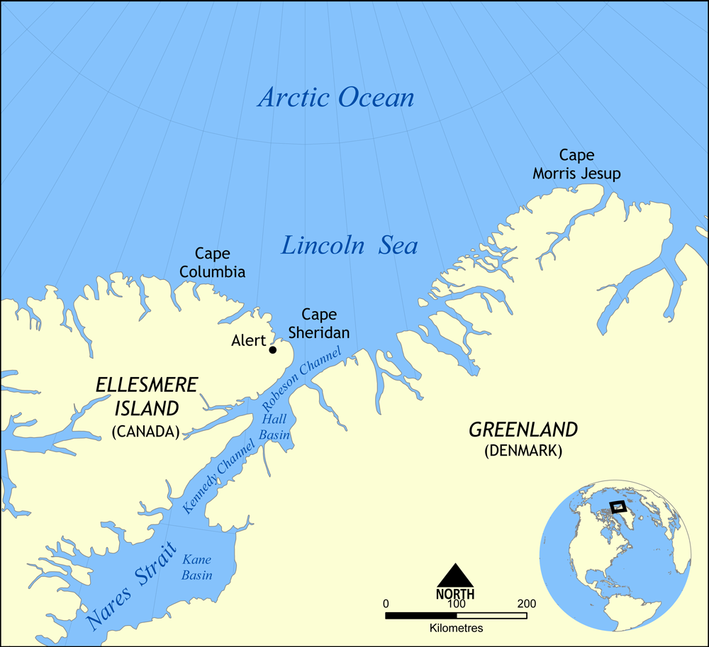
Map showing the location of the Lincoln Sea, part of the Arctic Ocean. Also shows Cape Columbia and Cape Morris Jesup.
Created by NormanEinstein, May 30, 2006.
I, the copyright holder of this work, hereby publish it under the following license:

|
ਇਸ ਸਫ਼ੇ ਨੂੰ ਗਨੂ ਲਸੰਸ, ਵਰਜ਼ਨ 1.2 ਜਾਂ ਫਰੀ ਸਾਫਟਵੇਅਰ ਫਾਊਂਡੇਸ਼ਨ ਦੁਆਰਾ ਪ੍ਰਕਾਸ਼ਿਤ ਕੀਤੇ ਨਵੇਂ ਵਰਜ਼ਨ ਤਹਿਤ ਕਾਪੀ ਕਰਨ, ਵੰਡਣ ਜਾਂ/ਅਤੇ ਤਬਦੀਲੀ ਕਰਨ ਦੀ ਖੁੱਲ ਹੈ; ਬਿਨਾ ਕਿਸੇ ਸਥਿਰ ਫਰੰਟ-ਕਵਰ ਜਾਂ ਬੈਕ ਕਵਰ ਲਿਖਤਾਂ ਤੋਂ ਬਿਨਾਂ। ਇਸ ਲਸੰਸ ਦੀ ਇੱਕ ਕਾਪੀ ਇਸ ਗਨੂ ਫਰੀ ਲਸੰਸ ਭਾਗ ਵਿੱਚ ਮੌਜੂਦ ਹੈ। |
| ਇਸ ਫ਼ਾਈਲ ਦਾ ਲਸੰਸ ਕ੍ਰਿਏਟਿਵ ਕਾਮਨਜ਼ ਐਟ੍ਰੀਬਿਊਸ਼ਨ-ਸ਼ੇਅਰ ਅਲਾਈਕ 3.0 ਅਨਪੋਰਟੇਡ ਹੈ। | ||
| ||
| This licensing tag was added to this file as part of the GFDL licensing update. |
ਫ਼ਾਈਲ ਦਾ ਅਤੀਤ
ਤਾਰੀਖ/ਸਮੇਂ ’ਤੇ ਕਲਿੱਕ ਕਰੋ ਤਾਂ ਉਸ ਸਮੇਂ ਦੀ ਫਾਈਲ ਪੇਸ਼ ਹੋ ਜਾਵੇਗੀ।
| ਮਿਤੀ/ਸਮਾਂ | ਨਮੂਨਾ | ਨਾਪ | ਵਰਤੋਂਕਾਰ | ਟਿੱਪਣੀ | |
|---|---|---|---|---|---|
| ਮੌਜੂਦਾ | 16:01, 7 ਅਗਸਤ 2007 | | 1,000 × 913 (302 KB) | NormanEinstein | Updated map. Slightly larger size. |
| 21:14, 6 ਅਗਸਤ 2007 |  | 657 × 600 (185 KB) | Eivindgh | ||
| 21:13, 6 ਅਗਸਤ 2007 |  | 657 × 600 (185 KB) | Eivindgh | ||
| 14:02, 30 ਮਈ 2006 |  | 996 × 909 (104 KB) | NormanEinstein | {{Information Map showing the location of the Lincoln Sea, part of the Arctic Ocean. Also shows Cape Columbia and Cape Morris Jesup. Created by NormanEinstein, May 30, 2006. {{GFDL-self}} Category:Maps of seas |
ਫ਼ਾਈਲ ਦੀ ਵਰਤੋਂ
ਇਹ ਫਾਈਲ ਹੇਠਾਂ ਦਿੱਤਾ ਸਫ਼ਾ ਵਰਤਦਾ ਹੈ:
ਫ਼ਾਈਲ ਦੀ ਵਿਆਪਕ ਵਰਤੋਂ
ਇਸ ਫ਼ਾਈਲ ਨੂੰ ਹੋਰ ਹੇਠ ਲਿਖੇ ਵਿਕੀ ਵਰਤਦੇ ਹਨ:
- af.wikipedia.org ਉੱਤੇ ਵਰਤੋਂ
- ar.wikipedia.org ਉੱਤੇ ਵਰਤੋਂ
- ast.wikipedia.org ਉੱਤੇ ਵਰਤੋਂ
- azb.wikipedia.org ਉੱਤੇ ਵਰਤੋਂ
- az.wikipedia.org ਉੱਤੇ ਵਰਤੋਂ
- bg.wikipedia.org ਉੱਤੇ ਵਰਤੋਂ
- bn.wikipedia.org ਉੱਤੇ ਵਰਤੋਂ
- bs.wikipedia.org ਉੱਤੇ ਵਰਤੋਂ
- ca.wikipedia.org ਉੱਤੇ ਵਰਤੋਂ
- ceb.wikipedia.org ਉੱਤੇ ਵਰਤੋਂ
- cs.wikipedia.org ਉੱਤੇ ਵਰਤੋਂ
- da.wikipedia.org ਉੱਤੇ ਵਰਤੋਂ
- de.wikipedia.org ਉੱਤੇ ਵਰਤੋਂ
- en.wikipedia.org ਉੱਤੇ ਵਰਤੋਂ
- es.wikipedia.org ਉੱਤੇ ਵਰਤੋਂ
- et.wikipedia.org ਉੱਤੇ ਵਰਤੋਂ
- eu.wikipedia.org ਉੱਤੇ ਵਰਤੋਂ
- fa.wikipedia.org ਉੱਤੇ ਵਰਤੋਂ
- fi.wikipedia.org ਉੱਤੇ ਵਰਤੋਂ
- fr.wikipedia.org ਉੱਤੇ ਵਰਤੋਂ
- he.wikipedia.org ਉੱਤੇ ਵਰਤੋਂ
ਇਸ ਫ਼ਾਈਲ ਦੀ ਹੋਰ ਵਿਆਪਕ ਵਰਤੋਂ ਵੇਖੋ।