
ਤਸਵੀਰ:Map of Great Barrier Reef Demis.png
ਇਸ ਝਾਤ ਦਾ ਅਕਾਰ: 535 × 599 ਪਿਕਸਲ. ਹੋਰ ਰੈਜ਼ੋਲਿਊਸ਼ਨਜ਼: 214 × 240 ਪਿਕਸਲ | 429 × 480 ਪਿਕਸਲ | 945 × 1,058 ਪਿਕਸਲ.
ਅਸਲ ਫ਼ਾਈਲ (945 × 1,058 ਪਿਕਸਲ, ਫ਼ਾਈਲ ਅਕਾਰ: 200 KB, MIME ਕਿਸਮ: image/png)
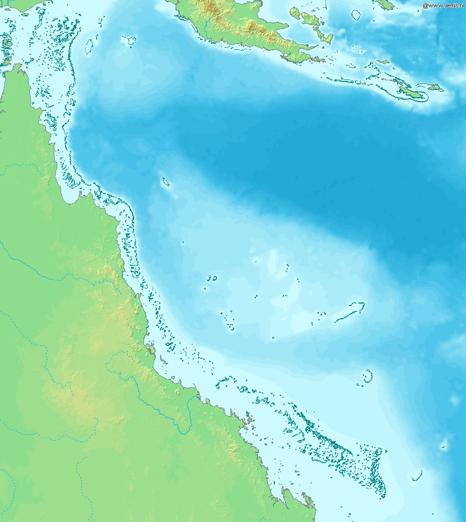
Map of Great Barrier Reef.
Bounding box West 142°, South -23°, East 155°, North -9°. Center at 16°00′00″S 148°30′00″E / 16.00000°S 148.50000°E.
This image is in the public domain because it came from the site https://www.demis.nl/products/web-map-server/examples/ and was released by the copyright holder. Permission is granted to copy, distribute and/or modify this map since it is based on free of copyright images from: www.demis.nl. See also approval email on de.wp and its clarification.
|
| This work has been released into the public domain by its copyright holder, www.demis.nl. This applies worldwide. In some countries this may not be legally possible; if so: www.demis.nl grants anyone the right to use this work for any purpose, without any conditions, unless such conditions are required by law.
|
ਫ਼ਾਈਲ ਦਾ ਅਤੀਤ
ਤਾਰੀਖ/ਸਮੇਂ ’ਤੇ ਕਲਿੱਕ ਕਰੋ ਤਾਂ ਉਸ ਸਮੇਂ ਦੀ ਫਾਈਲ ਪੇਸ਼ ਹੋ ਜਾਵੇਗੀ।
| ਮਿਤੀ/ਸਮਾਂ | ਨਮੂਨਾ | ਨਾਪ | ਵਰਤੋਂਕਾਰ | ਟਿੱਪਣੀ | |
|---|---|---|---|---|---|
| ਮੌਜੂਦਾ | 16:11, 20 ਦਸੰਬਰ 2006 | | 945 × 1,058 (200 KB) | Mats Halldin~commonswiki | Map of Great Barrier Reef. Bounding box West 142°, South -23°, East 155°, North -9°. Center at {{coor d|16.00000|S|148.50000|E|scale:8400000}}. {{demis-pd}} Category:Maps of Australia |
ਫ਼ਾਈਲ ਦੀ ਵਰਤੋਂ
ਇਸ ਫ਼ਾਈਲ ਦੀ ਵਰਤੋਂ ਕਰਨ ਵਾਲੇ ਕੋਈ ਪੰਨੇ ਨਹੀਂ ਹਨ।
ਫ਼ਾਈਲ ਦੀ ਵਿਆਪਕ ਵਰਤੋਂ
ਇਸ ਫ਼ਾਈਲ ਨੂੰ ਹੋਰ ਹੇਠ ਲਿਖੇ ਵਿਕੀ ਵਰਤਦੇ ਹਨ:
- af.wikipedia.org ਉੱਤੇ ਵਰਤੋਂ
- am.wikipedia.org ਉੱਤੇ ਵਰਤੋਂ
- ar.wikipedia.org ਉੱਤੇ ਵਰਤੋਂ
- as.wikipedia.org ਉੱਤੇ ਵਰਤੋਂ
- bn.wikipedia.org ਉੱਤੇ ਵਰਤੋਂ
- br.wikipedia.org ਉੱਤੇ ਵਰਤੋਂ
- bs.wikipedia.org ਉੱਤੇ ਵਰਤੋਂ
- ckb.wikipedia.org ਉੱਤੇ ਵਰਤੋਂ
- en.wikipedia.org ਉੱਤੇ ਵਰਤੋਂ
- es.wikipedia.org ਉੱਤੇ ਵਰਤੋਂ
- fiu-vro.wikipedia.org ਉੱਤੇ ਵਰਤੋਂ
- fo.wikipedia.org ਉੱਤੇ ਵਰਤੋਂ
- fr.wikipedia.org ਉੱਤੇ ਵਰਤੋਂ
- gan.wikipedia.org ਉੱਤੇ ਵਰਤੋਂ
- he.wikipedia.org ਉੱਤੇ ਵਰਤੋਂ
- id.wikipedia.org ਉੱਤੇ ਵਰਤੋਂ
- ja.wikipedia.org ਉੱਤੇ ਵਰਤੋਂ
- jv.wikipedia.org ਉੱਤੇ ਵਰਤੋਂ
- ka.wikipedia.org ਉੱਤੇ ਵਰਤੋਂ
- kn.wikipedia.org ਉੱਤੇ ਵਰਤੋਂ
- la.wikipedia.org ਉੱਤੇ ਵਰਤੋਂ
- mai.wikipedia.org ਉੱਤੇ ਵਰਤੋਂ
- mk.wikipedia.org ਉੱਤੇ ਵਰਤੋਂ
- ml.wikipedia.org ਉੱਤੇ ਵਰਤੋਂ
- mr.wikipedia.org ਉੱਤੇ ਵਰਤੋਂ
- ms.wikipedia.org ਉੱਤੇ ਵਰਤੋਂ
- ne.wikipedia.org ਉੱਤੇ ਵਰਤੋਂ
- new.wikipedia.org ਉੱਤੇ ਵਰਤੋਂ
- oc.wikipedia.org ਉੱਤੇ ਵਰਤੋਂ
- pnb.wikipedia.org ਉੱਤੇ ਵਰਤੋਂ
- sah.wikipedia.org ਉੱਤੇ ਵਰਤੋਂ
- sh.wikipedia.org ਉੱਤੇ ਵਰਤੋਂ
- sk.wikipedia.org ਉੱਤੇ ਵਰਤੋਂ
- ta.wikipedia.org ਉੱਤੇ ਵਰਤੋਂ
- th.wikipedia.org ਉੱਤੇ ਵਰਤੋਂ
- ur.wikipedia.org ਉੱਤੇ ਵਰਤੋਂ
- vep.wikipedia.org ਉੱਤੇ ਵਰਤੋਂ
- xmf.wikipedia.org ਉੱਤੇ ਵਰਤੋਂ
- yi.wikipedia.org ਉੱਤੇ ਵਰਤੋਂ