
ਤਸਵੀਰ:Mercator north pole 1595.jpg
ਇਸ ਝਾਤ ਦਾ ਅਕਾਰ: 635 × 600 ਪਿਕਸਲ. ਹੋਰ ਰੈਜ਼ੋਲਿਊਸ਼ਨਜ਼: 254 × 240 ਪਿਕਸਲ | 508 × 480 ਪਿਕਸਲ | 813 × 768 ਪਿਕਸਲ | 1,084 × 1,024 ਪਿਕਸਲ | 1,700 × 1,606 ਪਿਕਸਲ.
ਅਸਲ ਫ਼ਾਈਲ (1,700 × 1,606 ਪਿਕਸਲ, ਫ਼ਾਈਲ ਅਕਾਰ: 1.13 MB, MIME ਕਿਸਮ: image/jpeg)
ਸਾਰ
| ਵੇਰਵਾ |
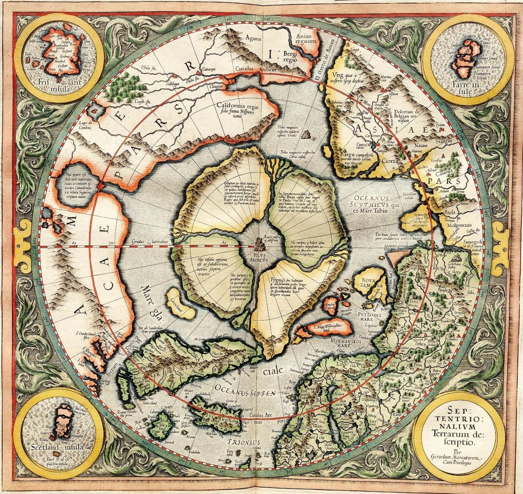
Mercator's 1595 map of the Arctic. Mercator, Gerhard, 1512-1594. "Septentrionalium Terrarum descriptio" [1595]. First state, from his posthumously published atlas, Atlantis pars altera. |
||||||||||||||||||||||||||
| ਮਿਤੀ | |||||||||||||||||||||||||||
| ਸਰੋਤ | http://libweb5.princeton.edu/visual_materials/maps/websites/northwest-passage/mercator.htm | ||||||||||||||||||||||||||
| ਲਿਖਾਰੀ |
|
||||||||||||||||||||||||||
| ਇਜਾਜ਼ਤ (ਇਸ ਫ਼ਾਈਲ ਦੀ ਮੁੜਵਰਤੋਂ ਕਰੋ) |
|
||||||||||||||||||||||||||

ਲਸੰਸ
|
This work is in the public domain in its country of origin and other countries and areas where the copyright term is the author's life plus 100 years or fewer. | |
| This file has been identified as being free of known restrictions under copyright law, including all related and neighboring rights. | |
_-_Geographicus_-_NorthPole-mercator-1606.jpg)
]
ਫ਼ਾਈਲ ਦਾ ਅਤੀਤ
ਤਾਰੀਖ/ਸਮੇਂ ’ਤੇ ਕਲਿੱਕ ਕਰੋ ਤਾਂ ਉਸ ਸਮੇਂ ਦੀ ਫਾਈਲ ਪੇਸ਼ ਹੋ ਜਾਵੇਗੀ।
| ਮਿਤੀ/ਸਮਾਂ | ਨਮੂਨਾ | ਨਾਪ | ਵਰਤੋਂਕਾਰ | ਟਿੱਪਣੀ | |
|---|---|---|---|---|---|
| ਮੌਜੂਦਾ | 11:32, 14 ਮਾਰਚ 2008 | | 1,700 × 1,606 (1.13 MB) | Pallidio~commonswiki | {{Information |Description= |Source= |Date= |Author= |Permission= |other_versions= }} Maps made in the 16th century | Gerardus Mercator | Maps by Gerardus Mercator | 1595 | Old maps of the world | |
ਫ਼ਾਈਲ ਦੀ ਵਰਤੋਂ
ਇਹ ਫਾਈਲ ਹੇਠਾਂ ਦਿੱਤਾ ਸਫ਼ਾ ਵਰਤਦਾ ਹੈ:
ਫ਼ਾਈਲ ਦੀ ਵਿਆਪਕ ਵਰਤੋਂ
ਇਸ ਫ਼ਾਈਲ ਨੂੰ ਹੋਰ ਹੇਠ ਲਿਖੇ ਵਿਕੀ ਵਰਤਦੇ ਹਨ:
- ba.wikipedia.org ਉੱਤੇ ਵਰਤੋਂ
- be-tarask.wikipedia.org ਉੱਤੇ ਵਰਤੋਂ
- be.wikipedia.org ਉੱਤੇ ਵਰਤੋਂ
- de.wikipedia.org ਉੱਤੇ ਵਰਤੋਂ
- en.wikipedia.org ਉੱਤੇ ਵਰਤੋਂ
- eo.wikipedia.org ਉੱਤੇ ਵਰਤੋਂ
- es.wikipedia.org ਉੱਤੇ ਵਰਤੋਂ
- fr.wikipedia.org ਉੱਤੇ ਵਰਤੋਂ
- hy.wikipedia.org ਉੱਤੇ ਵਰਤੋਂ
- it.wikipedia.org ਉੱਤੇ ਵਰਤੋਂ
- ja.wikipedia.org ਉੱਤੇ ਵਰਤੋਂ
- ka.wikipedia.org ਉੱਤੇ ਵਰਤੋਂ
- la.wikipedia.org ਉੱਤੇ ਵਰਤੋਂ
- nl.wikipedia.org ਉੱਤੇ ਵਰਤੋਂ
- pl.wikipedia.org ਉੱਤੇ ਵਰਤੋਂ
- ru.wikipedia.org ਉੱਤੇ ਵਰਤੋਂ
- sv.wikipedia.org ਉੱਤੇ ਵਰਤੋਂ
- te.wikipedia.org ਉੱਤੇ ਵਰਤੋਂ
- te.wiktionary.org ਉੱਤੇ ਵਰਤੋਂ
- tt.wikipedia.org ਉੱਤੇ ਵਰਤੋਂ
- zh.wikipedia.org ਉੱਤੇ ਵਰਤੋਂ