
ਤਸਵੀਰ:Road network CPEC.jpg
ਇਸ ਝਾਤ ਦਾ ਅਕਾਰ: 799 × 600 ਪਿਕਸਲ. ਹੋਰ ਰੈਜ਼ੋਲਿਊਸ਼ਨਜ਼: 320 × 240 ਪਿਕਸਲ | 640 × 480 ਪਿਕਸਲ | 962 × 722 ਪਿਕਸਲ.
ਅਸਲ ਫ਼ਾਈਲ (962 × 722 ਪਿਕਸਲ, ਫ਼ਾਈਲ ਅਕਾਰ: 137 KB, MIME ਕਿਸਮ: image/jpeg)
ਸਾਰ
| ਵੇਰਵਾ |
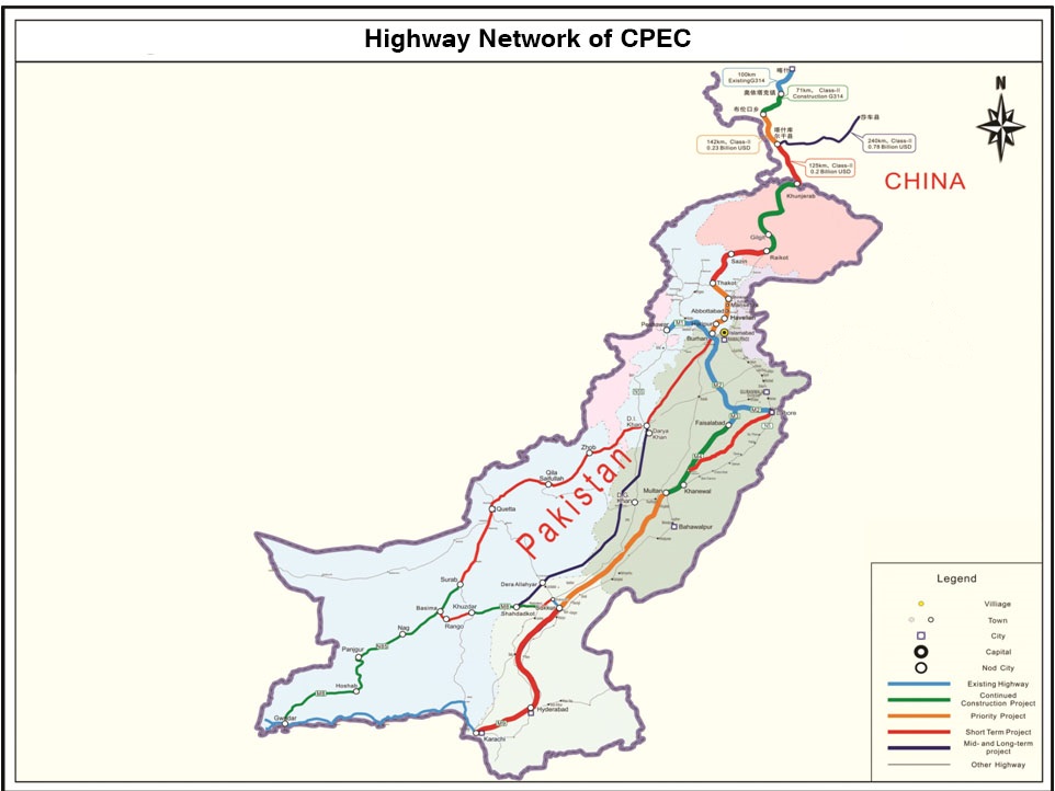
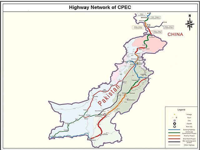
English: It describes Eastern Western and Central alignment of CPEC |
| ਮਿਤੀ | |
| ਸਰੋਤ | http://www.pc.gov.pk/wp-content/uploads/2016/01/Highway-Network-of-cpac-new.jpg |
| ਲਿਖਾਰੀ | Government of Pakistan |
This file is in the public domain because Planning commision of Pakistan
|
ਫ਼ਾਈਲ ਦਾ ਅਤੀਤ
ਤਾਰੀਖ/ਸਮੇਂ ’ਤੇ ਕਲਿੱਕ ਕਰੋ ਤਾਂ ਉਸ ਸਮੇਂ ਦੀ ਫਾਈਲ ਪੇਸ਼ ਹੋ ਜਾਵੇਗੀ।
| ਮਿਤੀ/ਸਮਾਂ | ਨਮੂਨਾ | ਨਾਪ | ਵਰਤੋਂਕਾਰ | ਟਿੱਪਣੀ | |
|---|---|---|---|---|---|
| ਮੌਜੂਦਾ | 00:19, 28 ਸਤੰਬਰ 2023 | | 962 × 722 (137 KB) | Eggrollll | Reverted to version as of 17:10, 4 December 2020 (UTC) |
| 17:11, 4 ਦਸੰਬਰ 2020 |  | 962 × 722 (125 KB) | Pathfinder454 | Map published by user Badri2017 is forged / edited without copyrights obtained from Government of Pakistan. Original file published by user Baltistani478 is the actual map depicting road networks of CPEC as published at official website http://cpec.gov.pk/map-single/1 Therefore File Reverted to version as of 16:49, 23 May 2016 (UTC) | |
| 17:10, 4 ਦਸੰਬਰ 2020 |  | 962 × 722 (137 KB) | Pathfinder454 | Reverted to version as of 10:15, 19 July 2017 (UTC) Map published by user Badri2017 is forged / edited without copyrights obtained from Government of Pakistan. Original file published by user Baltistani478 is the actual map depicting road networks of CPEC as published at official website http://cpec.gov.pk/map-single/1 Therefore File Reverted to version as of 16:49, 23 May 2016 (UTC | |
| 17:01, 4 ਦਸੰਬਰ 2020 |  | 962 × 722 (125 KB) | Pathfinder454 | Map published by user Badri2017 is forged / edited without copyrights obtained from Government of Pakistan. Original file published by user Baltistani478 is the actual map depicting road networks of CPEC as published at official website http://cpec.gov.pk/map-single/1 Therefore File Reverted to version as of 16:49, 23 May 2016 (UTC) | |
| 10:15, 19 ਜੁਲਾਈ 2017 |  | 962 × 722 (137 KB) | Badri2017 | Neutral Map, Indian administered Kashmir is neither part of CPEC nor Pak territory | |
| 16:49, 23 ਮਈ 2016 |  | 962 × 722 (125 KB) | Baltistani478 | {{subst:Upload marker added by en.wp UW}} {{Information |Description = {{en|It describes Eastern Western and Central alignment of CPEC}} |Source = http://www.pc.gov.pk/wp-content/uploads/2016/01/Highway-Network-of-cpac-new.jpg |Date = January 2016 |Aut... |
ਫ਼ਾਈਲ ਦੀ ਵਰਤੋਂ
ਇਹ ਫਾਈਲ ਹੇਠਾਂ ਦਿੱਤਾ ਸਫ਼ਾ ਵਰਤਦਾ ਹੈ:
ਫ਼ਾਈਲ ਦੀ ਵਿਆਪਕ ਵਰਤੋਂ
ਇਸ ਫ਼ਾਈਲ ਨੂੰ ਹੋਰ ਹੇਠ ਲਿਖੇ ਵਿਕੀ ਵਰਤਦੇ ਹਨ:
- ar.wikipedia.org ਉੱਤੇ ਵਰਤੋਂ
- bn.wikipedia.org ਉੱਤੇ ਵਰਤੋਂ
- ca.wikipedia.org ਉੱਤੇ ਵਰਤੋਂ
- en.wikipedia.org ਉੱਤੇ ਵਰਤੋਂ
- eo.wikinews.org ਉੱਤੇ ਵਰਤੋਂ
- hi.wikipedia.org ਉੱਤੇ ਵਰਤੋਂ
- mr.wikipedia.org ਉੱਤੇ ਵਰਤੋਂ
- pnb.wikipedia.org ਉੱਤੇ ਵਰਤੋਂ
- sat.wikipedia.org ਉੱਤੇ ਵਰਤੋਂ
- sd.wikipedia.org ਉੱਤੇ ਵਰਤੋਂ
- ta.wikipedia.org ਉੱਤੇ ਵਰਤੋਂ
- zh.wikipedia.org ਉੱਤੇ ਵਰਤੋਂ