
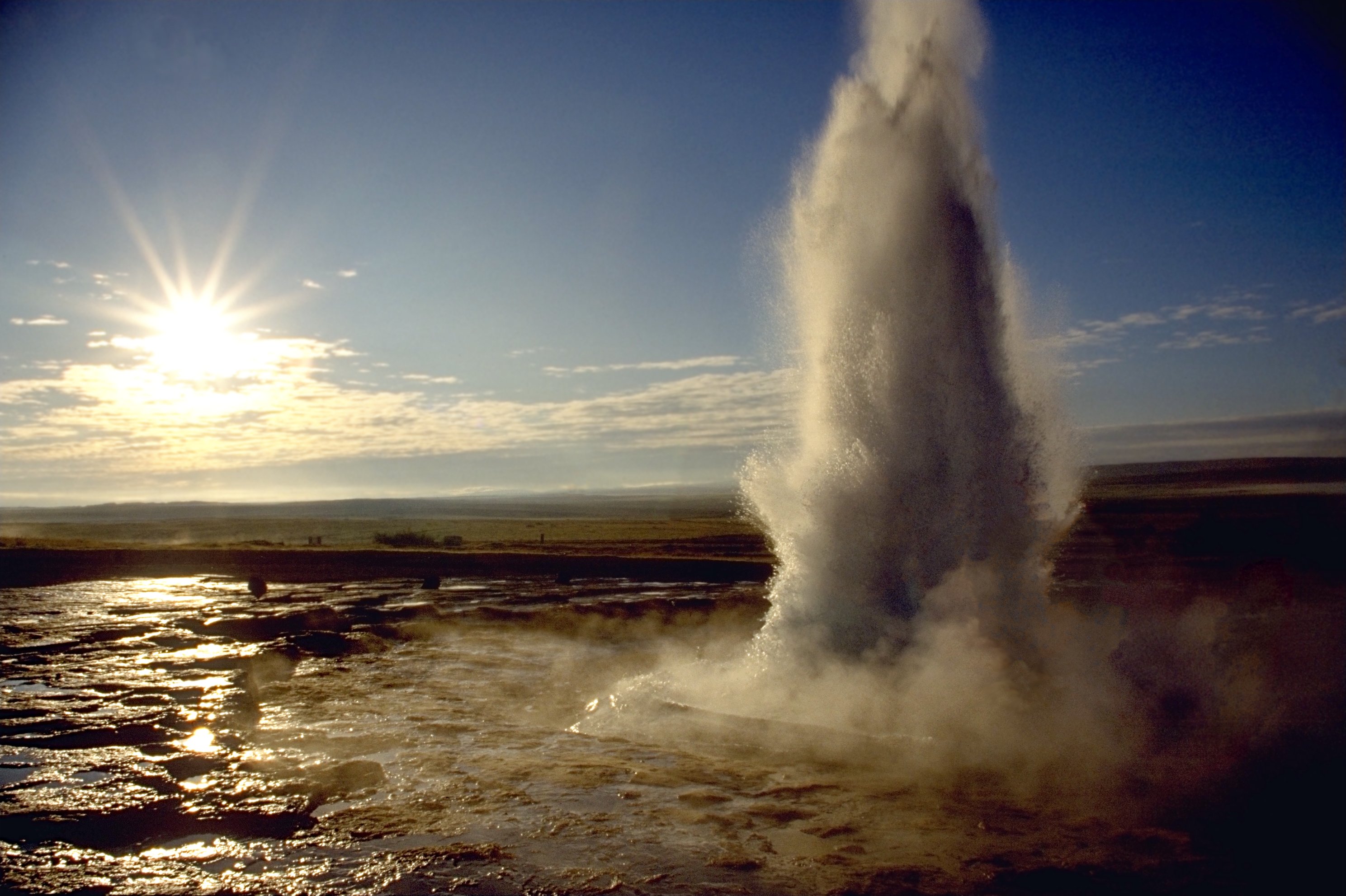
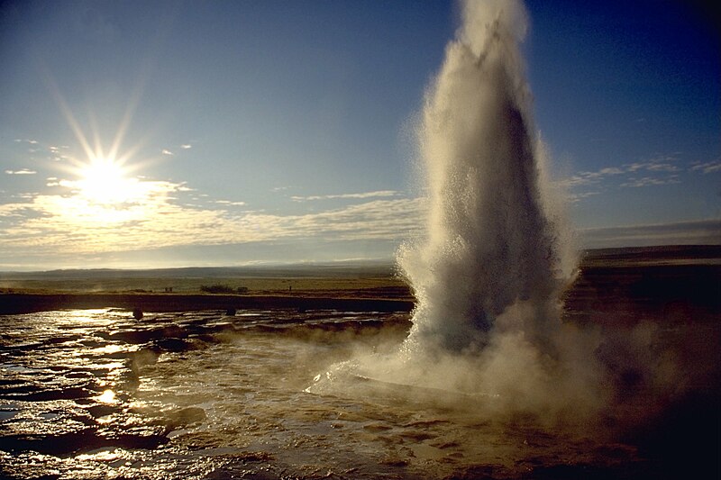
ਤਸਵੀਰ:Strokkur geyser eruption, close-up view.jpg
ਇਸ ਝਾਤ ਦਾ ਅਕਾਰ: 800 × 533 ਪਿਕਸਲ. ਹੋਰ ਰੈਜ਼ੋਲਿਊਸ਼ਨਜ਼: 320 × 213 ਪਿਕਸਲ | 640 × 426 ਪਿਕਸਲ | 1,024 × 682 ਪਿਕਸਲ | 1,280 × 853 ਪਿਕਸਲ | 2,977 × 1,983 ਪਿਕਸਲ.
ਅਸਲ ਫ਼ਾਈਲ (2,977 × 1,983 ਪਿਕਸਲ, ਫ਼ਾਈਲ ਅਕਾਰ: 695 KB, MIME ਕਿਸਮ: image/jpeg)
| ਵੇਰਵਾ |
العربية: انفجار الفوَّارة الحارَّة «ستروكر».
Deutsch: Ein Ausbruch des Strokkur auf Island.
English: Eruption of Strokkur close by.
Français : Une éruption du Strokkur, en Islande. |
||
| ਮਿਤੀ | |||
| ਸਰੋਤ |
ਆਪਣਾ ਕੰਮ - see http://fam-tille.de/sparetime.html |
||
| ਲਿਖਾਰੀ | Andreas Tille | ||
| ਇਜਾਜ਼ਤ (ਇਸ ਫ਼ਾਈਲ ਦੀ ਮੁੜਵਰਤੋਂ ਕਰੋ) |
Quote of http://fam-tille.de/island/iceland/geysir/1998_088.html - Permission is granted to copy, distribute and/or modify this images under the terms of the GNU Free Documentation License, Version 1.1 or any later version published by the Free Software Foundation. I, the copyright holder of this work, hereby publish it under the following licenses:
This file is licensed under the Creative Commons Attribution-Share Alike 3.0 Unported, 2.5 Generic, 2.0 Generic and 1.0 Generic license.
ਤੁਸੀਂ ਆਪਣੀ ਮਰਜ਼ੀ ਦਾ ਲਸੰਸ ਚੁਣ ਸਕਦੇ ਹੋ। |

| Camera location | | View this and other nearby images on: OpenStreetMap |
|---|
| Camera Model | Minolta 600si |
|---|---|
| Lens | 28-80 |
| Filter(s) | none |
| Support | simple tripod |
| Film | Kodak slide |
|
This image was selected as picture of the day on Wikimedia Commons for 7 March 2005. It was captioned as follows: Other languages:
|
ਫ਼ਾਈਲ ਦਾ ਅਤੀਤ
ਤਾਰੀਖ/ਸਮੇਂ ’ਤੇ ਕਲਿੱਕ ਕਰੋ ਤਾਂ ਉਸ ਸਮੇਂ ਦੀ ਫਾਈਲ ਪੇਸ਼ ਹੋ ਜਾਵੇਗੀ।
| ਮਿਤੀ/ਸਮਾਂ | ਨਮੂਨਾ | ਨਾਪ | ਵਰਤੋਂਕਾਰ | ਟਿੱਪਣੀ | |
|---|---|---|---|---|---|
| ਮੌਜੂਦਾ | 21:37, 9 ਦਸੰਬਰ 2005 | | 2,977 × 1,983 (695 KB) | Tillea | |
| 06:16, 17 ਜਨਵਰੀ 2005 |  | 2,644 × 1,983 (542 KB) | Tillea | Eruption of Geysir close by |
ਫ਼ਾਈਲ ਦੀ ਵਰਤੋਂ
ਇਹ ਫਾਈਲ ਹੇਠਾਂ ਦਿੱਤਾ ਸਫ਼ਾ ਵਰਤਦਾ ਹੈ:
ਫ਼ਾਈਲ ਦੀ ਵਿਆਪਕ ਵਰਤੋਂ
ਇਸ ਫ਼ਾਈਲ ਨੂੰ ਹੋਰ ਹੇਠ ਲਿਖੇ ਵਿਕੀ ਵਰਤਦੇ ਹਨ:
- af.wikipedia.org ਉੱਤੇ ਵਰਤੋਂ
- an.wikipedia.org ਉੱਤੇ ਵਰਤੋਂ
- ar.wikipedia.org ਉੱਤੇ ਵਰਤੋਂ
- arz.wikipedia.org ਉੱਤੇ ਵਰਤੋਂ
- azb.wikipedia.org ਉੱਤੇ ਵਰਤੋਂ
- bg.wikipedia.org ਉੱਤੇ ਵਰਤੋਂ
- bh.wikipedia.org ਉੱਤੇ ਵਰਤੋਂ
- bn.wikipedia.org ਉੱਤੇ ਵਰਤੋਂ
- bs.wikipedia.org ਉੱਤੇ ਵਰਤੋਂ
- ca.wikipedia.org ਉੱਤੇ ਵਰਤੋਂ
- csb.wikipedia.org ਉੱਤੇ ਵਰਤੋਂ
- cs.wikipedia.org ਉੱਤੇ ਵਰਤੋਂ
- cy.wikipedia.org ਉੱਤੇ ਵਰਤੋਂ
- da.wikipedia.org ਉੱਤੇ ਵਰਤੋਂ
- da.wiktionary.org ਉੱਤੇ ਵਰਤੋਂ
- de.wikipedia.org ਉੱਤੇ ਵਰਤੋਂ
- de.wikibooks.org ਉੱਤੇ ਵਰਤੋਂ
- de.wiktionary.org ਉੱਤੇ ਵਰਤੋਂ
- en.wikipedia.org ਉੱਤੇ ਵਰਤੋਂ
ਇਸ ਫ਼ਾਈਲ ਦੀ ਹੋਰ ਵਿਆਪਕ ਵਰਤੋਂ ਵੇਖੋ।