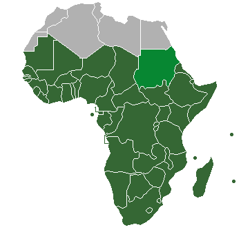
ਤਸਵੀਰ:Sub-Saharan Africa definition UN.png
Sub-Saharan_Africa_definition_UN.png (362 × 340 ਪਿਕਸਲ, ਫ਼ਾਈਲ ਅਕਾਰ: 6 KB, MIME ਕਿਸਮ: image/png)
ਫ਼ਾਈਲ ਦਾ ਅਤੀਤ
ਤਾਰੀਖ/ਸਮੇਂ ’ਤੇ ਕਲਿੱਕ ਕਰੋ ਤਾਂ ਉਸ ਸਮੇਂ ਦੀ ਫਾਈਲ ਪੇਸ਼ ਹੋ ਜਾਵੇਗੀ।
| ਮਿਤੀ/ਸਮਾਂ | ਨਮੂਨਾ | ਨਾਪ | ਵਰਤੋਂਕਾਰ | ਟਿੱਪਣੀ | |
|---|---|---|---|---|---|
| ਮੌਜੂਦਾ | 20:47, 19 ਜੁਲਾਈ 2013 |  | 362 × 340 (6 KB) | Maproom | Reshaded South Sudan, which the UN now regards as in East Africa, not North Africa: see http://unstats.un.org/unsd/methods/m49/m49regin.htm |
| 13:27, 12 ਅਪਰੈਲ 2012 |  | 362 × 340 (9 KB) | Hazhk | Adding different shading for Sudan & S. Sudan because they're also classified as being part of North Africa by the UN | |
| 22:02, 9 ਜੁਲਾਈ 2011 |  | 356 × 344 (11 KB) | Maphobbyist | South Sudan has become independent on July 9, 2011. Sudan and South Sudan are shown with the new international border between them. | |
| 06:46, 31 ਮਾਰਚ 2011 |  | 356 × 344 (10 KB) | Hoshie | added Cabinda (Angola) to map | |
| 11:18, 15 ਦਸੰਬਰ 2010 |  | 356 × 344 (6 KB) | Jcherlet | {{Information |Description=Definition of Sub-Saharan Africa, according to the United Nations institutions |Source=*File:HDImap_spectrum2006_Africa.png |Date=2010-12-15 11:13 (UTC) |Author=*Jcherlet: '''Jcherlet''' *derivative work: |
ਫ਼ਾਈਲ ਦੀ ਵਰਤੋਂ
ਇਹ ਫਾਈਲ ਹੇਠਾਂ ਦਿੱਤਾ ਸਫ਼ਾ ਵਰਤਦਾ ਹੈ:
ਫ਼ਾਈਲ ਦੀ ਵਿਆਪਕ ਵਰਤੋਂ
ਇਸ ਫ਼ਾਈਲ ਨੂੰ ਹੋਰ ਹੇਠ ਲਿਖੇ ਵਿਕੀ ਵਰਤਦੇ ਹਨ:
- ast.wikipedia.org ਉੱਤੇ ਵਰਤੋਂ
- ca.wikipedia.org ਉੱਤੇ ਵਰਤੋਂ
- ckb.wikipedia.org ਉੱਤੇ ਵਰਤੋਂ
- cs.wikipedia.org ਉੱਤੇ ਵਰਤੋਂ
- de.wikipedia.org ਉੱਤੇ ਵਰਤੋਂ
- en.wikipedia.org ਉੱਤੇ ਵਰਤੋਂ
- Sub-Saharan Africa
- Water supply and sanitation in sub-Saharan Africa
- Wikipedia:Reference desk/Archives/Humanities/2013 October 5
- Category:Birds of Sub-Saharan Africa
- Category:Fauna of Sub-Saharan Africa
- Category:Biota of Sub-Saharan Africa
- Category:Mammals of Sub-Saharan Africa
- User:DexDor/Categorization of organisms by geography
- Category:Moths of Sub-Saharan Africa
- Category:Amphibians of Sub-Saharan Africa
- et.wikipedia.org ਉੱਤੇ ਵਰਤੋਂ
- ha.wikipedia.org ਉੱਤੇ ਵਰਤੋਂ
- he.wikipedia.org ਉੱਤੇ ਵਰਤੋਂ
- id.wikipedia.org ਉੱਤੇ ਵਰਤੋਂ
- ig.wikipedia.org ਉੱਤੇ ਵਰਤੋਂ
- ilo.wikipedia.org ਉੱਤੇ ਵਰਤੋਂ
- it.wikipedia.org ਉੱਤੇ ਵਰਤੋਂ
- ja.wikipedia.org ਉੱਤੇ ਵਰਤੋਂ
- ka.wikipedia.org ਉੱਤੇ ਵਰਤੋਂ
- ko.wikipedia.org ਉੱਤੇ ਵਰਤੋਂ
- lt.wikipedia.org ਉੱਤੇ ਵਰਤੋਂ
- pnb.wikipedia.org ਉੱਤੇ ਵਰਤੋਂ
- ro.wikipedia.org ਉੱਤੇ ਵਰਤੋਂ
- simple.wikipedia.org ਉੱਤੇ ਵਰਤੋਂ
- sr.wikipedia.org ਉੱਤੇ ਵਰਤੋਂ
- sv.wikipedia.org ਉੱਤੇ ਵਰਤੋਂ
- ta.wikipedia.org ਉੱਤੇ ਵਰਤੋਂ
- th.wikipedia.org ਉੱਤੇ ਵਰਤੋਂ
- tn.wikipedia.org ਉੱਤੇ ਵਰਤੋਂ
- tr.wikipedia.org ਉੱਤੇ ਵਰਤੋਂ
- ur.wikipedia.org ਉੱਤੇ ਵਰਤੋਂ
ਇਸ ਫ਼ਾਈਲ ਦੀ ਹੋਰ ਵਿਆਪਕ ਵਰਤੋਂ ਵੇਖੋ।


