
ਤਸਵੀਰ:Txu-oclc-224571178-se19-10.jpg

ਇਸ ਝਾਤ ਦਾ ਅਕਾਰ: 796 × 600 ਪਿਕਸਲ. ਹੋਰ ਰੈਜ਼ੋਲਿਊਸ਼ਨਜ਼: 319 × 240 ਪਿਕਸਲ | 637 × 480 ਪਿਕਸਲ | 1,020 × 768 ਪਿਕਸਲ | 1,280 × 964 ਪਿਕਸਲ | 2,560 × 1,928 ਪਿਕਸਲ | 5,242 × 3,948 ਪਿਕਸਲ.
ਅਸਲ ਫ਼ਾਈਲ (5,242 × 3,948 ਪਿਕਸਲ, ਫ਼ਾਈਲ ਅਕਾਰ: 6.42 MB, MIME ਕਿਸਮ: image/jpeg)
ਸਾਰ
| ਵੇਰਵਾ |
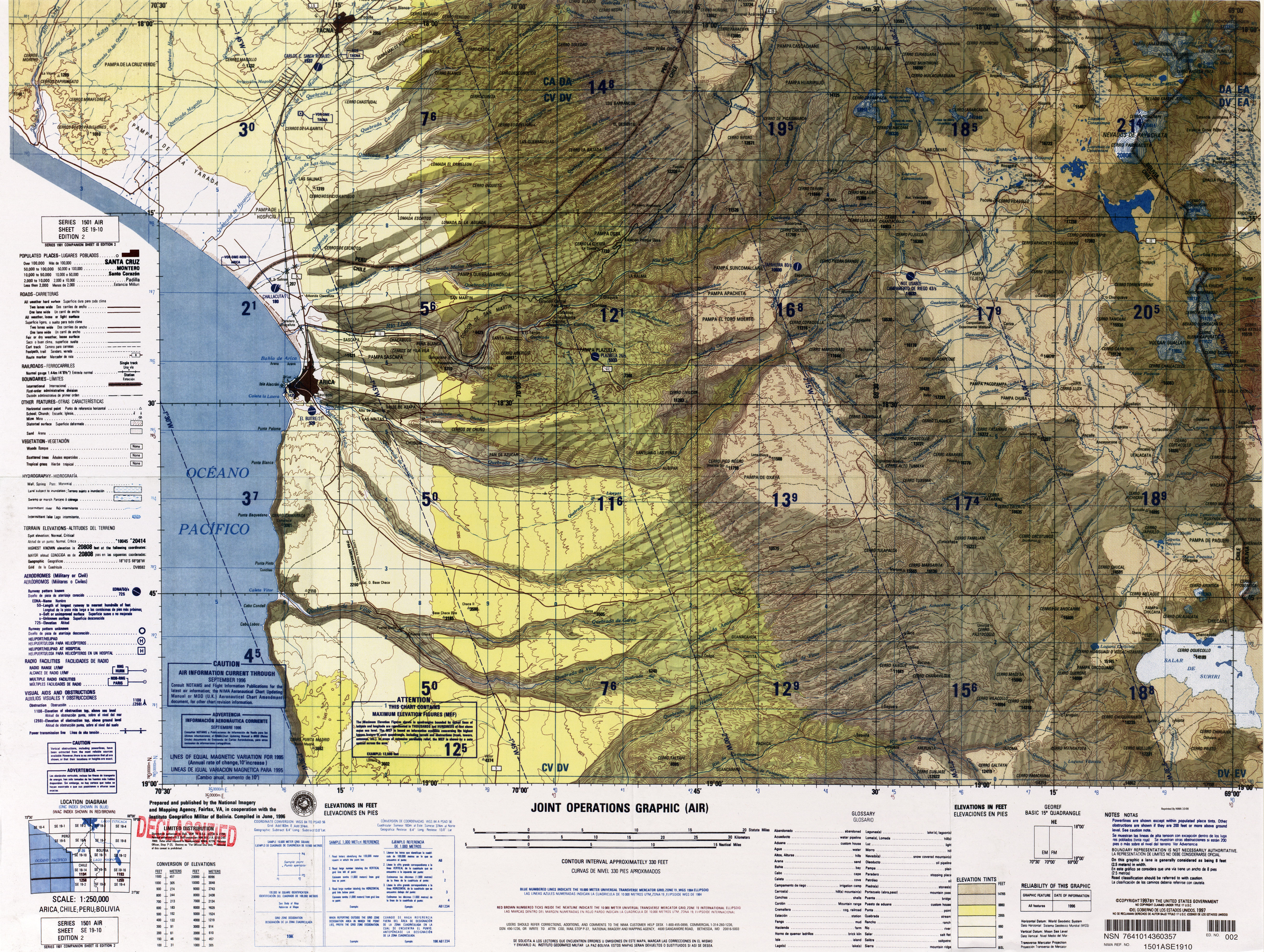
English: Arica, Tacna |
|||
| ਸਰੋਤ | http://www.lib.utexas.edu/maps/jog/latin_america/txu-oclc-224571178-se19-10.jpg | |||
| ਲਿਖਾਰੀ | This work is in the public domain in the United States because it is a work of the United States Federal Government under the terms of 17 U.S.C. § 105. See Copyright. | |||
| ਇਜਾਜ਼ਤ (ਇਸ ਫ਼ਾਈਲ ਦੀ ਮੁੜਵਰਤੋਂ ਕਰੋ) |
|
|||
| Other versions | Derivative works of this file: Canal-lauca.jpg |

.jpg)
ਫ਼ਾਈਲ ਦਾ ਅਤੀਤ
ਤਾਰੀਖ/ਸਮੇਂ ’ਤੇ ਕਲਿੱਕ ਕਰੋ ਤਾਂ ਉਸ ਸਮੇਂ ਦੀ ਫਾਈਲ ਪੇਸ਼ ਹੋ ਜਾਵੇਗੀ।
| ਮਿਤੀ/ਸਮਾਂ | ਨਮੂਨਾ | ਨਾਪ | ਵਰਤੋਂਕਾਰ | ਟਿੱਪਣੀ | |
|---|---|---|---|---|---|
| ਮੌਜੂਦਾ | 23:12, 30 ਦਸੰਬਰ 2011 | | 5,242 × 3,948 (6.42 MB) | Keysanger | {{Information |Description ={{en|1=Arica, Tacna}} |Source =http://www.lib.utexas.edu/maps/jog/latin_america/txu-oclc-224571178-se19-10.jpg |Author =This work is in the public domain in the United States because it is a work of the Unite |
ਫ਼ਾਈਲ ਦੀ ਵਰਤੋਂ
ਇਸ ਫ਼ਾਈਲ ਦੀ ਵਰਤੋਂ ਕਰਨ ਵਾਲੇ ਕੋਈ ਪੰਨੇ ਨਹੀਂ ਹਨ।
ਫ਼ਾਈਲ ਦੀ ਵਿਆਪਕ ਵਰਤੋਂ
ਇਸ ਫ਼ਾਈਲ ਨੂੰ ਹੋਰ ਹੇਠ ਲਿਖੇ ਵਿਕੀ ਵਰਤਦੇ ਹਨ:
- ay.wikipedia.org ਉੱਤੇ ਵਰਤੋਂ
- de.wikipedia.org ਉੱਤੇ ਵਰਤੋਂ
- en.wikipedia.org ਉੱਤੇ ਵਰਤੋਂ
- Lauca River
- Lluta River
- Cotacotani Lake
- Camarones River
- Cosapilla River
- Template:Arica y Parinacota Region rivers and lakes
- Uchusuma River
- Canal Lauca
- Pukintika
- Ch'iyar Quta (Oruro)
- Laram Q'awa (Charaña)
- Laram Q'awa (Parinacota)
- Jach'a Kunturiri (Oruro)
- Kunturiri (Bolivia and Chile)
- Wila Qullu (Turco)
- Uqi Uqini
- Sura K'uchu (Bolivia)
- Umurata
- List of rivers of the Arica y Parinacota Region
- Ari Qullu Phujru
- Canal Mauri
- Canal Uchusuma
- Chungará Lake
- eo.wikipedia.org ਉੱਤੇ ਵਰਤੋਂ
- es.wikipedia.org ਉੱਤੇ ਵਰਤੋਂ
- fa.wikipedia.org ਉੱਤੇ ਵਰਤੋਂ
- fr.wikipedia.org ਉੱਤੇ ਵਰਤੋਂ
- incubator.wikimedia.org ਉੱਤੇ ਵਰਤੋਂ
- qu.wikipedia.org ਉੱਤੇ ਵਰਤੋਂ
ਇਸ ਫ਼ਾਈਲ ਦੀ ਹੋਰ ਵਿਆਪਕ ਵਰਤੋਂ ਵੇਖੋ।