
ਤਸਵੀਰ:Vatican City map EN.png

ਇਸ ਝਾਤ ਦਾ ਅਕਾਰ: 777 × 600 ਪਿਕਸਲ. ਹੋਰ ਰੈਜ਼ੋਲਿਊਸ਼ਨਜ਼: 311 × 240 ਪਿਕਸਲ | 622 × 480 ਪਿਕਸਲ | 995 × 768 ਪਿਕਸਲ | 1,280 × 988 ਪਿਕਸਲ | 2,560 × 1,977 ਪਿਕਸਲ | 2,888 × 2,230 ਪਿਕਸਲ.
ਅਸਲ ਫ਼ਾਈਲ (2,888 × 2,230 ਪਿਕਸਲ, ਫ਼ਾਈਲ ਅਕਾਰ: 2.41 MB, MIME ਕਿਸਮ: image/png)
ਸਾਰ
| Description |
Deutsch: Karte der Vatikanstadt (englische Version)
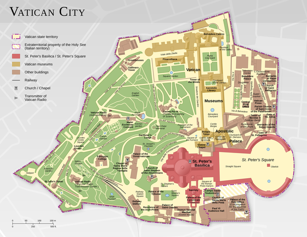
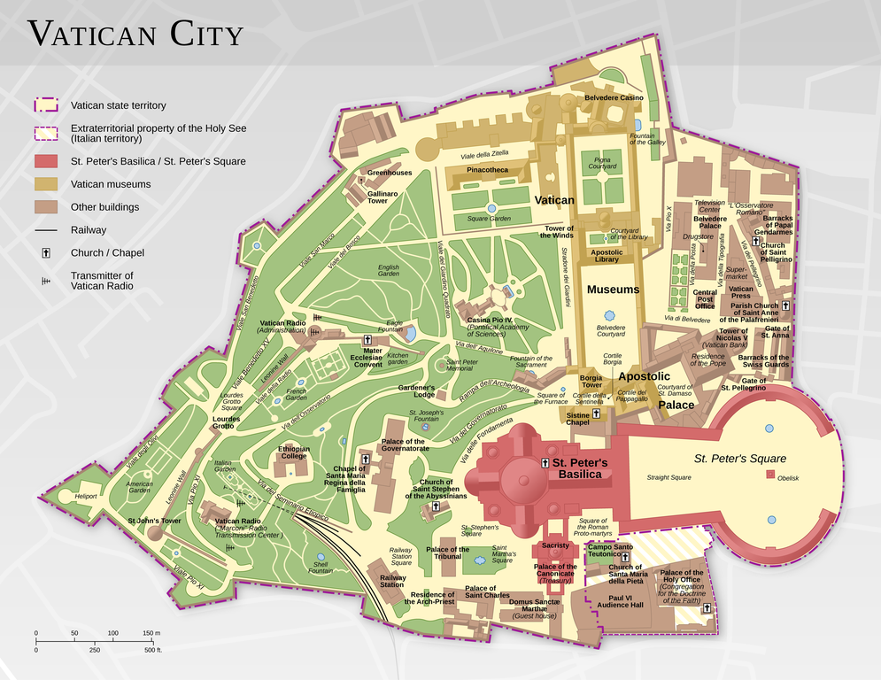
English: Map of the Vatican City (English version)
Español: Mapa de la Ciudad del Vaticano (versión en inglés).
Suomi: Vatikaanin kartta (englanninkielinen versio)
Français : Carte de la Cité du Vatican, à partir d'informations d'OpenStreetMap. Version en anglais ; voir la version en français ici : Vatican City map FR.png
中文:梵蒂冈城国地图(英语版本)
Bosanski: Karta Vatikana - sadrži kartografske podatke sa projekta ©OpenStreetMap (ODbL).
|
|||||||||
| ਮਿਤੀ | ||||||||||
| ਸਰੋਤ |
ਆਪਣਾ ਕੰਮ |
|||||||||
| Creator | ||||||||||
| ਇਜਾਜ਼ਤ (ਇਸ ਫ਼ਾਈਲ ਦੀ ਮੁੜਵਰਤੋਂ ਕਰੋ) |
|
|||||||||
| Geotemporal data | ||||||||||
| Bounding box |
|
|||||||||
| Georeferencing | ||||||||||
| Other versions |
|
|||||||||


|
This map has been made or improved in the German Kartenwerkstatt (Map Lab). You can propose maps to improve as well.
|
ਲਸੰਸ
ਇਸ ਫ਼ਾਈਲ ਦਾ ਲਸੰਸ ਕ੍ਰਿਏਟਿਵ ਕਾਮਨਜ਼ ਐਟ੍ਰੀਬਿਊਸ਼ਨ-ਸ਼ੇਅਰ ਅਲਾਈਕ 3.0 ਅਨਪੋਰਟੇਡ ਹੈ।
ਐਟਰੀਬਿਊਸ਼ਨ: Thomas Römer/OpenStreetMap data
- ਤੁਹਾਨੂੰ ਖੁੱਲ੍ਹ ਹੈ:
- ਸਾਂਝਾ ਕਰਨ ਦੀ – ਰਚਨਾ ਨੂੰ ਕਾਪੀ, ਵੰਡਣਾ ਅਤੇ ਭੇਜਣਾ
- ਮੁੜ-ਰਲ਼ਾਉਣ ਦੀ – ਰਚਨਾ ਨੂੰ ਢਾਲਣਾ
- ਥੱਲੇ ਲਿਖੀਆਂ ਸ਼ਰਤਾਂ ਹੇਠ:
- ਗੁਣਾਂ ਦੀ ਦੱਸ – ਉਚਿਤ ਕ੍ਰੈਡਿਟ ਦੇਵੋ, ਲਾਇਸੰਸ ਦਾ ਇੱਕ ਲਿੰਕ ਪ੍ਰਦਾਨ ਕਰੋ ਅਤੇ ਇਹ ਦਰਸਾਓ ਕਿ ਕੀ ਤਬਦੀਲੀਆਂ ਕੀਤੀਆਂ ਗਈਆਂ ਸਨ। ਤੁਸੀਂ ਇਹ ਕਿਸੇ ਵੀ ਵਾਜਬ ਤਰੀਕੇ ਨਾਲ ਕਰ ਸਕਦੇ ਹੋ, ਪਰ ਇਹ ਤਰੀਕਾ ਅਜਿਹਾ ਨਹੀਂ ਹੋਣਾ ਚਾਹੀਦਾ ਜੋ ਇਹ ਦਰਸਾਵੇ ਕਿ ਲਾਇਸੰਸਕਰਤਾ ਤੁਹਾਨੂੰ ਜਾਂ ਤੁਹਾਡੀ ਵਰਤੋਂ ਦਾ ਸਮਰਥਨ ਕਰਦਾ ਹੈ।
- ਸ਼ੇਅਰ ਅਲਾਈਕ – ਜੇਕਰ ਤੁਸੀਂ ਸਮੱਗਰੀ ਨੂੰ ਰੀਮਿਕਸ ਕਰਦੇ ਹੋ, ਬਦਲਦੇ ਹੋ ਜਾਂ ਬਣਾਉਂਦੇ ਹੋ, ਤਾਂ ਆਪਣੇ ਯੋਗਦਾਨ ਇੱਕੋ ਜਿਹੇ ਜਾਂ ਅਨੁਕੂਲ ਲਾਇਸੰਸ ਦੇ ਅਧੀਨ ਕਰੋ।
Assessment
|

This image was selected as picture of the day on Wikimedia Commons for 11 February 2015. It was captioned as follows: Other languages:
Bosanski: Karta Vatikana - sadrži kartografske podatke sa projekta ©OpenStreetMap (ODbL). |
ਫ਼ਾਈਲ ਦਾ ਅਤੀਤ
ਤਾਰੀਖ/ਸਮੇਂ ’ਤੇ ਕਲਿੱਕ ਕਰੋ ਤਾਂ ਉਸ ਸਮੇਂ ਦੀ ਫਾਈਲ ਪੇਸ਼ ਹੋ ਜਾਵੇਗੀ।
| ਮਿਤੀ/ਸਮਾਂ | ਨਮੂਨਾ | ਨਾਪ | ਵਰਤੋਂਕਾਰ | ਟਿੱਪਣੀ | |
|---|---|---|---|---|---|
| ਮੌਜੂਦਾ | 11:44, 12 ਫ਼ਰਵਰੀ 2021 | | 2,888 × 2,230 (2.41 MB) | Foghe | St. Damasco → St. Damaso. |
| 09:22, 11 ਅਪਰੈਲ 2013 |  | 2,888 × 2,230 (2.14 MB) | Thoroe | larger render | |
| 17:12, 10 ਅਪਰੈਲ 2013 |  | 1,733 × 1,338 (1.11 MB) | Thoroe | small fixes | |
| 15:59, 23 ਮਾਰਚ 2013 |  | 1,733 × 1,338 (1.1 MB) | Thoroe | minor fixes | |
| 00:41, 23 ਮਾਰਚ 2013 |  | 1,733 × 1,338 (1.09 MB) | Thoroe | {{Information |Description ={{en|1=Map of the Vatican City (English version)}} {{de|1=Karte der Vatikanstadt (englische Version)}} |Source ={{own}} *[http://www.vatican.va/news_services/press/docume... |
ਫ਼ਾਈਲ ਦੀ ਵਰਤੋਂ
ਇਸ ਫ਼ਾਈਲ ਦੀ ਵਰਤੋਂ ਕਰਨ ਵਾਲੇ ਕੋਈ ਪੰਨੇ ਨਹੀਂ ਹਨ।
ਫ਼ਾਈਲ ਦੀ ਵਿਆਪਕ ਵਰਤੋਂ
ਇਸ ਫ਼ਾਈਲ ਨੂੰ ਹੋਰ ਹੇਠ ਲਿਖੇ ਵਿਕੀ ਵਰਤਦੇ ਹਨ:
- af.wikipedia.org ਉੱਤੇ ਵਰਤੋਂ
- be-tarask.wikipedia.org ਉੱਤੇ ਵਰਤੋਂ
- ca.wikipedia.org ਉੱਤੇ ਵਰਤੋਂ
- crh.wikipedia.org ਉੱਤੇ ਵਰਤੋਂ
- cv.wikipedia.org ਉੱਤੇ ਵਰਤੋਂ
- de.wikipedia.org ਉੱਤੇ ਵਰਤੋਂ
- en.wikipedia.org ਉੱਤੇ ਵਰਤੋਂ
- Wikipedia:Featured pictures/Diagrams, drawings, and maps/Maps
- Talk:Vatican City/Archive 1
- User talk:Thoroe
- Wikipedia:Featured pictures thumbs/37
- User talk:Crisco 1492/Archive 44
- Wikipedia:Featured picture candidates/Vatican City map
- Wikipedia:Featured picture candidates/October-2013
- Wikipedia:Picture of the day/August 2015
- Template:POTD/2015-08-07
- Wikipedia:Main Page history/2015 August 7
- User:John Paul II/Line of Popes
- Portal:Geography/Selected picture
- User:ਕਰਨ 13/sandbox
- en.wikivoyage.org ਉੱਤੇ ਵਰਤੋਂ
- fo.wikipedia.org ਉੱਤੇ ਵਰਤੋਂ
- fr.wikipedia.org ਉੱਤੇ ਵਰਤੋਂ
- hu.wikipedia.org ਉੱਤੇ ਵਰਤੋਂ
- ka.wikipedia.org ਉੱਤੇ ਵਰਤੋਂ
- ko.wikipedia.org ਉੱਤੇ ਵਰਤੋਂ
- krc.wikipedia.org ਉੱਤੇ ਵਰਤੋਂ
- lbe.wikipedia.org ਉੱਤੇ ਵਰਤੋਂ
- www.mediawiki.org ਉੱਤੇ ਵਰਤੋਂ
- mg.wikipedia.org ਉੱਤੇ ਵਰਤੋਂ
- os.wikipedia.org ਉੱਤੇ ਵਰਤੋਂ
- pl.wikipedia.org ਉੱਤੇ ਵਰਤੋਂ
- pt.wikipedia.org ਉੱਤੇ ਵਰਤੋਂ
- ru.wikipedia.org ਉੱਤੇ ਵਰਤੋਂ
- ru.wikinews.org ਉੱਤੇ ਵਰਤੋਂ
- sah.wikipedia.org ਉੱਤੇ ਵਰਤੋਂ
- sv.wikipedia.org ਉੱਤੇ ਵਰਤੋਂ
- tr.wikipedia.org ਉੱਤੇ ਵਰਤੋਂ
- tt.wikipedia.org ਉੱਤੇ ਵਰਤੋਂ
ਇਸ ਫ਼ਾਈਲ ਦੀ ਹੋਰ ਵਿਆਪਕ ਵਰਤੋਂ ਵੇਖੋ।