
ਇਬੀਸਾ: ਰੀਵਿਜ਼ਨਾਂ ਵਿਚ ਫ਼ਰਕ
ਸਮੱਗਰੀ ਮਿਟਾਈ ਸਮੱਗਰੀ ਜੋੜੀ
ਛੋ The file Image:Circle_sheer_blue_27.gif has been replaced by Image:Circle_sheer_blue_27.png by administrator commons:User:GifTagger: ''Replacing GIF by exact PNG duplicate.''. ''Translate me!'' |
Satdeepbot (ਗੱਲ-ਬਾਤ | ਯੋਗਦਾਨ) ਛੋ clean up using AWB |
||
| ਲਾਈਨ 1: | ਲਾਈਨ 1: | ||
{{Infobox islands |
{{Infobox islands |
||
| name |
| name = ਇਬੀਸਾ |
||
| image name |
| image name = Ibiza flag.svg |
||
| image caption |
| image caption = ਇਬੀਸਾ ਦਾ ਝੰਡਾ |
||
| image size |
| image size = 242px |
||
| locator map |
| locator map = {{Location map|Spain|float=center|lat=38.98|long=1.43|mark=Circle_sheer_blue_27.png|marksize=27|caption=}}Ibiza is midway between Spain's coastline and the larger island of [[Majorca]].<br />[[File:Localització d'Eivissa respecte les Illes Balears.svg|border|250px]]<br />Ibiza (west of Majorca) in [[Balearic Islands]] |
||
| native name |
| native name = Eivissa |
||
| native name link = ਕਾਤਾਲਾਨ ਭਾਸ਼ਾ |
| native name link = ਕਾਤਾਲਾਨ ਭਾਸ਼ਾ |
||
| nickname |
| nickname = |
||
| location |
| location = [[ਬਾਲੇਆਰਿਕ ਸਮੂੰਦਰ]] |
||
| coordinates |
| coordinates = {{Coord|38.98|N|1.43|E|region:ES_type:isle_scale:3000000|display=inline,title|display=inline,title}} |
||
| archipelago |
| archipelago = [[ਬਾਲੇਆਰਿਕ ਟਾਪੂ]], [[ਪਿਤੀਉਸਿਕ ਟਾਪੂs]] |
||
| total islands |
| total islands = |
||
| major islands |
| major islands = |
||
| area km2 |
| area km2 = 571.6 |
||
| highest mount |
| highest mount = [[ਸਾ ਤਾਲਾਈਸਾ]] |
||
| elevation m |
| elevation m = 475 |
||
| coastline km |
| coastline km = |
||
| state |
| state = ਸਪੇਨ |
||
| country |
| country = {{Flag|ਸਪੇਨ}} |
||
| country admin divisions title 1 |
| country admin divisions title 1 = [[ਖ਼ੁਦਮੁਖ਼ਤਿਆਰ ਸੰਗਠਨ]] |
||
| country admin divisions 1 |
| country admin divisions 1 = [[ਬਾਲੇਆਰਿਕ ਟਾਪੂ]] |
||
| country admin divisions title 2 |
| country admin divisions title 2 = [[ਸੂਬਾ]] |
||
| country admin divisions 2 |
| country admin divisions 2 = [[ਬਾਲੇਆਰਿਕ ਟਾਪੂ]] |
||
| country admin divisions title 3 |
| country admin divisions title 3 = |
||
| country admin divisions 3 |
| country admin divisions 3 = |
||
| country capital |
| country capital = [[ਇਬੀਸਾ ਕਸਬਾ]] |
||
| country largest city |
| country largest city = [[ਇਬੀਸਾ ਕਸਬਾ]] |
||
| country largest city population |
| country largest city population = 49,516 |
||
| country leader title |
| country leader title = |
||
| country leader name |
| country leader name = |
||
| population |
| population = 132,637 |
||
| population as of = 1 January 2010 |
| population as of = 1 January 2010 |
||
| density km2 |
| density km2 = 231.6 |
||
| ethnic groups |
| ethnic groups = |
||
| additional info |
| additional info = Official languages:<br />[[ਕਾਤਾਲਾਨ ਭਾਸ਼ਾ|ਕਾਤਾਲਾਨ]], [[ਸਪੇਨੀ ਭਾਸ਼ਾ|ਸਪੇਨੀ]]<br /><br />[[File:Official Emblem of Ibiza Island Council.svg|100px|center]]Ibiza Insular Council Emblem |
||
}} |
}} |
||
{{Infobox World Heritage Site |
{{Infobox World Heritage Site |
||
| WHS |
| WHS = ਇਬੀਸਾ |
||
| Image |
| Image = [[File:Ibiza old town harbour (236730060).jpg|242px]]<br />View of the port from the ramparts |
||
| State Party = ਸਪੇਨ |
| State Party = ਸਪੇਨ |
||
| Type |
| Type = ਮਿਸ਼੍ਰਿਤ |
||
| Criteria |
| Criteria = ii, iii, iv, ix, x |
||
| ID |
| ID = 417 |
||
| Region |
| Region = ਯੂਰਪ ਅਤੇ ਉੱਤਰੀ ਅਮਰੀਕਾ |
||
| Year |
| Year = 1999 |
||
| Session |
| Session = 23rd |
||
| Link |
| Link = http://whc.unesco.org/en/list/417 |
||
}} |
}} |
||
| ਲਾਈਨ 58: | ਲਾਈਨ 57: | ||
==ਇਤਿਹਾਸ== |
==ਇਤਿਹਾਸ== |
||
654 ਈਸਵੀ ਪੂਰਵ ਵਿੱਚ ਫੋਨੇਸ਼ੀਆਈ ਲੋਕਾਂ ਨੇ ਬਾਲੇਆਰਿਕ ਟਾਪੂਆਂ ਉੱਤੇ ਇੱਕ ਬੰਦਰਗਾਹ ਲਭ ਲਈ |
654 ਈਸਵੀ ਪੂਰਵ ਵਿੱਚ ਫੋਨੇਸ਼ੀਆਈ ਲੋਕਾਂ ਨੇ ਬਾਲੇਆਰਿਕ ਟਾਪੂਆਂ ਉੱਤੇ ਇੱਕ ਬੰਦਰਗਾਹ ਲਭ ਲਈ ਜਿਸ ਨੂੰ ਇਬੋਸਿਮ ਕਿਹਾ ਜਾਣ ਲੱਗਿਆ, ਮਿਸਰ ਦੇ ਸੰਗੀਤ ਅਤੇ ਨ੍ਰਿਤ ਦੇ ਦੇਵਤਾ ਦੇ ਨਾਮ ਅਨੁਸਾਰ। |
||
==ਵਾਤਾਵਰਨ== |
==ਵਾਤਾਵਰਨ== |
||
ਇਸ ਟਾਪੂ ਦਾ ਵਾਤਾਵਰਨ ਜ਼ਿਆਦਾਤਰ ਠੰਡਾ ਰਹਿੰਦਾ ਹੈ। ਤਾਪਮਾਨ 30°C ਤੋਂ ਉੱਤੇ ਕਦੇ ਕਦੇ ਹੀ ਜਾਂਦਾ ਹੈ ਨਹੀਂ ਤਾਂ ਇਹ 20°C ਦੇ ਆਸ ਪਾਸ ਰਹਿੰਦਾ ਹੈ। |
ਇਸ ਟਾਪੂ ਦਾ ਵਾਤਾਵਰਨ ਜ਼ਿਆਦਾਤਰ ਠੰਡਾ ਰਹਿੰਦਾ ਹੈ। ਤਾਪਮਾਨ 30 °C ਤੋਂ ਉੱਤੇ ਕਦੇ ਕਦੇ ਹੀ ਜਾਂਦਾ ਹੈ ਨਹੀਂ ਤਾਂ ਇਹ 20 °C ਦੇ ਆਸ ਪਾਸ ਰਹਿੰਦਾ ਹੈ। |
||
{{Weather box |
{{Weather box |
||
|location = Eivissa |
|location = Eivissa |
||
| ਲਾਈਨ 146: | ਲਾਈਨ 145: | ||
|year sun = 2732 |
|year sun = 2732 |
||
|source 1 = [[Agencia Estatal de Meteorología]]<ref>{{cite web |
|source 1 = [[Agencia Estatal de Meteorología]]<ref>{{cite web |
||
|url=http://www.aemet.es/es/elclima/datosclimatologicos/valoresclimatologicos?l=B954&k=bal |
|||
|title=Valores Climatológicos Normales. Ibiza / Aeropuerto |
|||
|accessdate=|date=June 2011}}</ref> |
|||
|date=September 2010}} |
|date=September 2010}} |
||
==ਗੈਲਰੀ== |
==ਗੈਲਰੀ== |
||
21:24, 15 ਨਵੰਬਰ 2015 ਦਾ ਦੁਹਰਾਅ
 | |
| ਭੂਗੋਲ | |
|---|---|
| ਟਿਕਾਣਾ | ਬਾਲੇਆਰਿਕ ਸਮੂੰਦਰ |
| ਗੁਣਕ | 38°59′N 1°26′E / 38.98°N 1.43°E |
| ਬਹੀਰਾ | ਬਾਲੇਆਰਿਕ ਟਾਪੂ, ਪਿਤੀਉਸਿਕ ਟਾਪੂs |
| ਪ੍ਰਸ਼ਾਸਨ | |
| ਜਨ-ਅੰਕੜੇ | |
| ਜਨਸੰਖਿਆ | 132,637 |
| UNESCO World Heritage Site | |
|---|---|
.jpg) View of the port from the ramparts | |
| Criteria | ਮਿਸ਼੍ਰਿਤ: ii, iii, iv, ix, x |
| Reference | 417 |
| Inscription | 1999 (23rd Session) |
ਇਬੀਸਾ ਭੂ-ਮੱਧ ਸਾਗਰ ਵਿੱਚ ਸਥਿਤ ਇੱਕ ਟਾਪੂ ਹੈ। ਇਹ ਪੂਰਬੀ ਸਪੇਨ ਵਿੱਚ ਵਾਲੇਂਸੀਆ ਸ਼ਹਿਰ ਤੋਂ 79 ਕਿਲੋਮੀਟਰ ਦੀ ਦੂਰੀ ਉੱਤੇ ਸਥਿਤ ਹੈ। ਇਹ ਬਾਲੇਆਰਿਕ ਟਾਪੂਆਂ ਦਾ ਤੀਜਾ ਸਭ ਤੋਂ ਵੱਡਾ ਟਾਪੂ ਹੈ।
ਇਬੀਸਾ ਦੇ ਇਬੀਸਾ ਕਸਬੇ ਵਿੱਚ ਹਰ ਸਾਲ ਹਜ਼ਾਰਾਂ ਸੈਲਾਨੀ ਆਉਂਦੇ ਹਨ। 1999 ਵਿੱਚ ਇਸਨੂੰ ਯੂਨੈਸਕੋ ਦੁਆਰਾ ਵਿਸ਼ਵ ਵਿਰਾਸਤ ਟਿਕਾਣਾ ਘੋਸ਼ਿਤ ਕੀਤਾ ਗਿਆ। [1]
ਨਾਮ
ਇਸ ਟਾਪੂ ਦਾ ਮੂਲ ਨਾਮ ਕਾਤਾਲਾਨ ਭਾਸ਼ਾ ਦਾ Eivissa ਹੈ ਅਤੇ ਸਪੇਨੀ ਵਿੱਚ ਇਸਨੂੰ "Ibiza" ਲਿਖਿਆ ਜਾਂਦਾ ਹੈ.
ਇਤਿਹਾਸ
654 ਈਸਵੀ ਪੂਰਵ ਵਿੱਚ ਫੋਨੇਸ਼ੀਆਈ ਲੋਕਾਂ ਨੇ ਬਾਲੇਆਰਿਕ ਟਾਪੂਆਂ ਉੱਤੇ ਇੱਕ ਬੰਦਰਗਾਹ ਲਭ ਲਈ ਜਿਸ ਨੂੰ ਇਬੋਸਿਮ ਕਿਹਾ ਜਾਣ ਲੱਗਿਆ, ਮਿਸਰ ਦੇ ਸੰਗੀਤ ਅਤੇ ਨ੍ਰਿਤ ਦੇ ਦੇਵਤਾ ਦੇ ਨਾਮ ਅਨੁਸਾਰ।
ਵਾਤਾਵਰਨ
ਇਸ ਟਾਪੂ ਦਾ ਵਾਤਾਵਰਨ ਜ਼ਿਆਦਾਤਰ ਠੰਡਾ ਰਹਿੰਦਾ ਹੈ। ਤਾਪਮਾਨ 30 °C ਤੋਂ ਉੱਤੇ ਕਦੇ ਕਦੇ ਹੀ ਜਾਂਦਾ ਹੈ ਨਹੀਂ ਤਾਂ ਇਹ 20 °C ਦੇ ਆਸ ਪਾਸ ਰਹਿੰਦਾ ਹੈ।
| ਸ਼ਹਿਰ ਦੇ ਪੌਣਪਾਣੀ ਅੰਕੜੇ | |||||||||||||
|---|---|---|---|---|---|---|---|---|---|---|---|---|---|
| ਮਹੀਨਾ | ਜਨ | ਫ਼ਰ | ਮਾਰ | ਅਪ | ਮਈ | ਜੂਨ | ਜੁਲ | ਅਗ | ਸਤੰ | ਅਕ | ਨਵੰ | ਦਸੰ | ਸਾਲ |
| ਔਸਤਨ ਉੱਚ ਤਾਪਮਾਨ °C (°F) | 15.5 (59.9) |
16.0 (60.8) |
17.2 (63) |
19.0 (66.2) |
22.2 (72) |
26.1 (79) |
29.3 (84.7) |
30.0 (86) |
27.6 (81.7) |
23.4 (74.1) |
19.3 (66.7) |
16.7 (62.1) |
21.9 (71.4) |
| ਰੋਜ਼ਾਨਾ ਔਸਤ °C (°F) | 11.8 (53.2) |
12.2 (54) |
13.2 (55.8) |
15.0 (59) |
18.2 (64.8) |
22.0 (71.6) |
25.0 (77) |
25.9 (78.6) |
23.6 (74.5) |
19.6 (67.3) |
15.6 (60.1) |
13.1 (55.6) |
17.9 (64.2) |
| ਔਸਤਨ ਹੇਠਲਾ ਤਾਪਮਾਨ °C (°F) | 8.1 (46.6) |
8.4 (47.1) |
9.3 (48.7) |
10.9 (51.6) |
14.2 (57.6) |
17.8 (64) |
20.7 (69.3) |
21.8 (71.2) |
19.5 (67.1) |
15.9 (60.6) |
12.0 (53.6) |
9.6 (49.3) |
14.0 (57.2) |
| ਬਰਸਾਤ mm (ਇੰਚ) | 38 (1.5) |
33 (1.3) |
36 (1.42) |
33 (1.3) |
26 (1.02) |
14 (0.55) |
6 (0.24) |
19 (0.75) |
48 (1.89) |
69 (2.72) |
51 (2.01) |
54 (2.13) |
439 (17.28) |
| ਔਸਤ. ਵਰਖਾ ਦਿਨ (≥ 1 mm) | 5 | 5 | 4 | 4 | 3 | 2 | 1 | 2 | 4 | 6 | 5 | 5 | 46 |
| ਔਸਤ ਮਹੀਨਾਵਾਰ ਧੁੱਪ ਦੇ ਘੰਟੇ | 161 | 167 | 207 | 243 | 277 | 297 | 335 | 302 | 237 | 198 | 164 | 148 | 2,732 |
| Source: Agencia Estatal de Meteorología[2] | |||||||||||||
ਗੈਲਰੀ
-
 Sun set across Sant Antoni Bay
 -
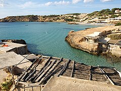
 Eivissa, Cala Salada, at north of Sant Antoni de Portmany
 -
 Staircase in Ibiza Town
 -
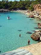
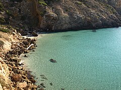
 Cala d'Hort, Ibiza
 -
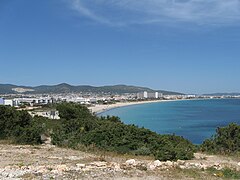
 Sant Antoni de Portmany from afar
 -
 The Egg of Columbus in Sant Antoni
 -
 The Platja d'en Bossa looking north towards Ibiza Town
 -
 Puig de Missa in Santa Eulària
 -
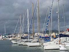 Marina of Santa Eulària des Riu
 -
 Sunset San Antonio
 -
 Private bay
 -
 Clear water
 -
 Cala Tarida
 -
Ibiza boat cruises
-
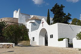
 Phoenician settlement remains on the headland at Sa Caleta


.jpg)


.JPG)
ਬਾਹਰੀ ਸਰੋਤ
Ibiza ਵਿਕੀਪੀਡੀਆ ਦੇ ਹੋਰ ਪ੍ਰਾਜੈਕਟਾਂ ਉੱਤੇ
 ਵਿਕਸ਼ਨਰੀ ਉੱਤੇ ਪਰਿਭਾਸ਼ਾਵਾਂ
  ਕਾਮਨਜ਼ ਉੱਤੇ ਮੀਡੀਆ
  ਵਿਕੀਖ਼ਬਰਾਂ ਉੱਤੇ ਖ਼ਬਰਾਂ
  ਵਿਕੀਕਥਨ ਉੱਤੇ ਕਥਨ
  ਵਿਕੀਸਰੋਤ ਉੱਤੇ ਲਿਖਤਾਂ
  ਵਿਕੀਕਿਤਾਬਾਂ ਉੱਤੇ ਕਿਤਾਬਾਂ
  ਵਿਕੀਵਰਸਿਟੀ ਉੱਤੇ Resources
  ਵਿਕੀਸਫ਼ਰ ਉੱਤੇ Travel information
- Consell Insular d'Eivissa (local government) (ਕਾਤਾਲਾਨ)
- "Official tourism portal of Ibiza" - Consell Insular d'Eivissa
- "Ibiza and the Historic Town of Eivissa" by The Guardian
- ↑ "Ibiza, Biodiversity and Culture" (in English).
{{cite web}}: Unknown parameter|access_date=ignored (help); Unknown parameter|editorial=ignored (help)CS1 maint: unrecognized language (link) - ↑ "Valores Climatológicos Normales. Ibiza / Aeropuerto". June 2011.
ਸ਼੍ਰੇਣੀਆਂ:
- ਫਰਮੇ ਦੀ ਵਰਤੋਂ ਵਿੱਚ ਦੁਹਰਾਇਆ ਕੁੰਜੀਆਂ
- Pages using infobox islands with unknown parameters
- Pages using infobox UNESCO World Heritage Site with unknown parameters
- Pages using Sister project links with hidden wikidata
- Pages using Sister project links with default search
- ਕਾਤਾਲਾਨ ਭਾਸ਼ਾਈ ਬਾਹਰੀ ਲੜ੍ਹੀਆਂ ਵਾਲੇ ਲੇਖ
- ਕਾਤਾਲਾਨ ਭਾਸ਼ਾ ਦੀਆਂ ਬਾਹਰੀ ਕੜੀਆਂ ਵਾਲੇ ਸਫ਼ੇ
- CS1 errors: unsupported parameter
- Pages with maps