
ਤਸਵੀਰ:1870 Nicaragua Canal Map Restoration.png
ਇਸ ਝਾਤ ਦਾ ਅਕਾਰ: 800 × 450 ਪਿਕਸਲ. ਹੋਰ ਰੈਜ਼ੋਲਿਊਸ਼ਨਜ਼: 320 × 180 ਪਿਕਸਲ | 640 × 360 ਪਿਕਸਲ | 1,024 × 576 ਪਿਕਸਲ | 1,280 × 720 ਪਿਕਸਲ | 2,685 × 1,510 ਪਿਕਸਲ.
ਅਸਲ ਫ਼ਾਈਲ (2,685 × 1,510 ਪਿਕਸਲ, ਫ਼ਾਈਲ ਅਕਾਰ: 2.1 MB, MIME ਕਿਸਮ: image/png)
ਸਾਰ
| ਵੇਰਵਾ |
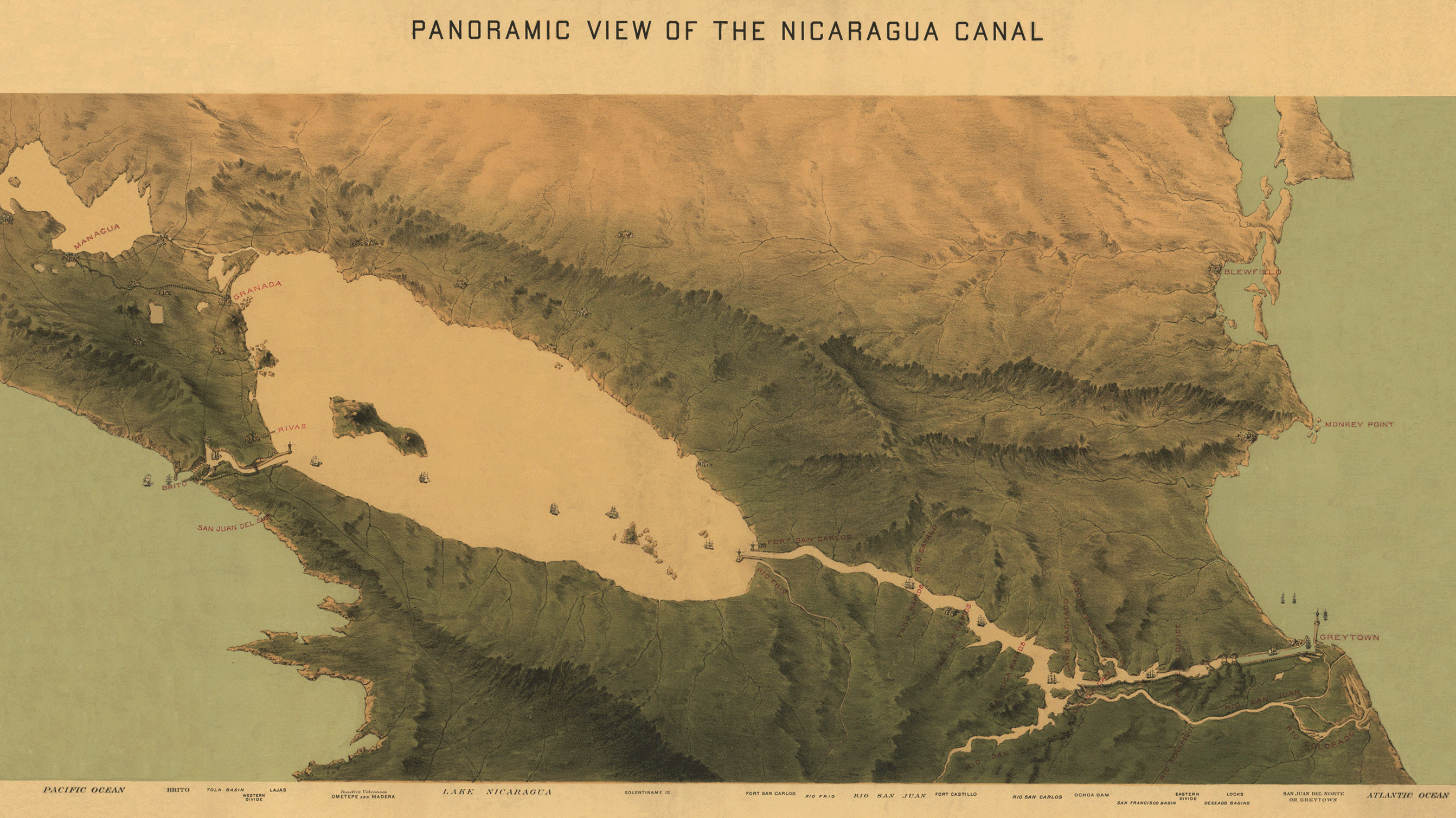
English: A c.1870 map of a plan for the Nicaragua Canal, drawn up by Julius Bien & Company. The map follows the southern route proposal. |
| ਮਿਤੀ | circa 1870 |
| ਸਰੋਤ | The Great Interoceanic Nicaragua Canal |
| ਲਿਖਾਰੀ | Julius Bien & Company |
| ਇਜਾਜ਼ਤ (ਇਸ ਫ਼ਾਈਲ ਦੀ ਮੁੜਵਰਤੋਂ ਕਰੋ) |
Per this, the map was published and registered with the United States Department of War. |
| Other versions | File:1870 Nicaragua Canal Map.png - unrestored version |
ਲਸੰਸ
This media file is in the public domain in the United States. This applies to U.S. works where the copyright has expired, often because its first publication occurred prior to January 1, 1929, and if not then due to lack of notice or renewal. See this page for further explanation.
|
 | |
 |
This image might not be in the public domain outside of the United States; this especially applies in the countries and areas that do not apply the rule of the shorter term for US works, such as Canada, Mainland China (not Hong Kong or Macao), Germany, Mexico, and Switzerland. The creator and year of publication are essential information and must be provided. See Wikipedia:Public domain and Wikipedia:Copyrights for more details.
|
ਫ਼ਾਈਲ ਦਾ ਅਤੀਤ
ਤਾਰੀਖ/ਸਮੇਂ ’ਤੇ ਕਲਿੱਕ ਕਰੋ ਤਾਂ ਉਸ ਸਮੇਂ ਦੀ ਫਾਈਲ ਪੇਸ਼ ਹੋ ਜਾਵੇਗੀ।
| ਮਿਤੀ/ਸਮਾਂ | ਨਮੂਨਾ | ਨਾਪ | ਵਰਤੋਂਕਾਰ | ਟਿੱਪਣੀ | |
|---|---|---|---|---|---|
| ਮੌਜੂਦਾ | 03:26, 14 ਫ਼ਰਵਰੀ 2015 | | 2,685 × 1,510 (2.1 MB) | A Texas Historian | User created page with UploadWizard |
ਫ਼ਾਈਲ ਦੀ ਵਰਤੋਂ
ਇਹ ਫਾਈਲ ਹੇਠਾਂ ਦਿੱਤਾ ਸਫ਼ਾ ਵਰਤਦਾ ਹੈ:
ਫ਼ਾਈਲ ਦੀ ਵਿਆਪਕ ਵਰਤੋਂ
ਇਸ ਫ਼ਾਈਲ ਨੂੰ ਹੋਰ ਹੇਠ ਲਿਖੇ ਵਿਕੀ ਵਰਤਦੇ ਹਨ:
- en.wikipedia.org ਉੱਤੇ ਵਰਤੋਂ
- es.wikipedia.org ਉੱਤੇ ਵਰਤੋਂ
- la.wikipedia.org ਉੱਤੇ ਵਰਤੋਂ
- vi.wikipedia.org ਉੱਤੇ ਵਰਤੋਂ