
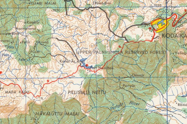
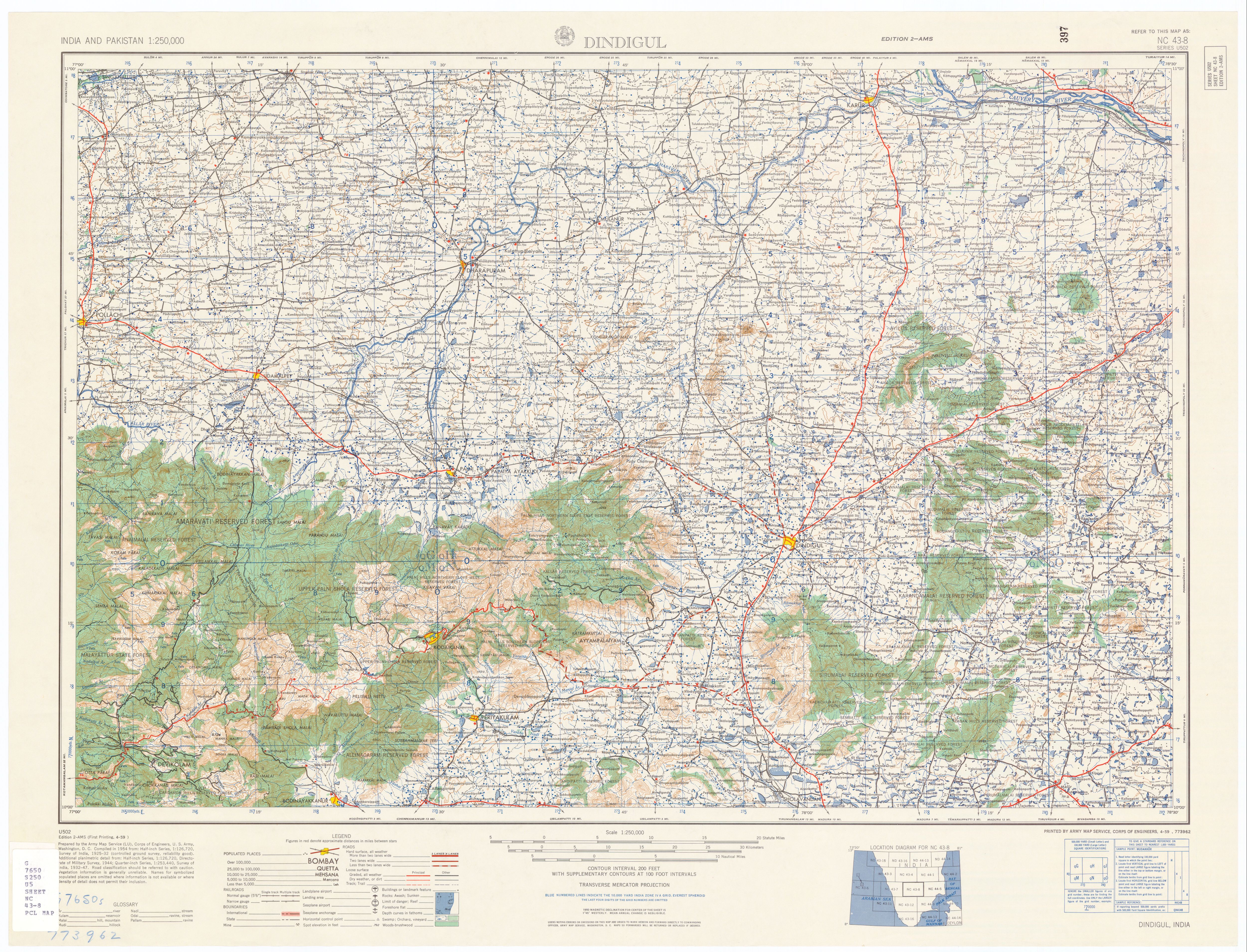
ਤਸਵੀਰ:AMS Berijam Lake.jpg
ਇਸ ਤੋਂ ਵੱਡੀ ਤਸਵੀਰ ਮੌਜੂਦ ਨਹੀਂ ਹੈ।
AMS_Berijam_Lake.jpg (648 × 431 ਪਿਕਸਲ, ਫ਼ਾਈਲ ਅਕਾਰ: 271 KB, MIME ਕਿਸਮ: image/jpeg)
ਸਾਰ
| ਵੇਰਵਾ | Berijam Lake/Fort Hamilton topographic map |
| ਮਿਤੀ | |
| ਸਰੋਤ | U.S. Army Topographic Command |
| ਲਿਖਾਰੀ | U.S. Army Map Service |
| ਇਜਾਜ਼ਤ (ਇਸ ਫ਼ਾਈਲ ਦੀ ਮੁੜਵਰਤੋਂ ਕਰੋ) |
Public domain |
| Other versions | http://www.lib.utexas.edu/maps/ams/india/nc-43-08.jpg |
ਲਸੰਸ
This file is a work of a U.S. Army soldier or employee, taken or made as part of that person's official duties. As a work of the U.S. federal government, it is in the public domain in the United States.
|
 |
ਫ਼ਾਈਲ ਦਾ ਅਤੀਤ
ਤਾਰੀਖ/ਸਮੇਂ ’ਤੇ ਕਲਿੱਕ ਕਰੋ ਤਾਂ ਉਸ ਸਮੇਂ ਦੀ ਫਾਈਲ ਪੇਸ਼ ਹੋ ਜਾਵੇਗੀ।
| ਮਿਤੀ/ਸਮਾਂ | ਨਮੂਨਾ | ਨਾਪ | ਵਰਤੋਂਕਾਰ | ਟਿੱਪਣੀ | |
|---|---|---|---|---|---|
| ਮੌਜੂਦਾ | 06:50, 10 ਦਸੰਬਰ 2008 | | 648 × 431 (271 KB) | Marcus334 | {{Information |Description=Berijam Lake/Fort Hamilton topographic map |Source=U.S. Army Topographic Command |Date=1955 |Author=U.S. Army Map Service |Permission=Public domain |other_versions=http://www.lib.utexas.edu/maps/ams/india/nc-43-08.jpg}} [[Categ |
ਫ਼ਾਈਲ ਦੀ ਵਰਤੋਂ
ਇਹ ਫਾਈਲ ਹੇਠਾਂ ਦਿੱਤਾ ਸਫ਼ਾ ਵਰਤਦਾ ਹੈ:
ਫ਼ਾਈਲ ਦੀ ਵਿਆਪਕ ਵਰਤੋਂ
ਇਸ ਫ਼ਾਈਲ ਨੂੰ ਹੋਰ ਹੇਠ ਲਿਖੇ ਵਿਕੀ ਵਰਤਦੇ ਹਨ:
- en.wikipedia.org ਉੱਤੇ ਵਰਤੋਂ
- pnb.wikipedia.org ਉੱਤੇ ਵਰਤੋਂ