ਵਿਕੀਪੀਡੀਆ, ਇੱਕ ਆਜ਼ਾਦ ਵਿਸ਼ਵਕੋਸ਼ ਤੋਂ
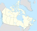
ਅਸਲ ਫ਼ਾਈਲ (SVG ਫ਼ਾਈਲ, ਆਮ ਤੌਰ ’ਤੇ 1,114 × 942 ਪਿਕਸਲ, ਫ਼ਾਈਲ ਦਾ ਅਕਾਰ: 365 KB)
ਇਹ ਫ਼ਾਈਲ Wikimedia Commons ਦੀ ਹੈ ਅਤੇ ਹੋਰ ਪਰਿਯੋਜਨਾਵਾਂ ਵਿੱਚ ਵੀ ਵਰਤੀ ਜਾ ਸਕਦੀ ਹੈ । ਇਸ ਫ਼ਾਈਲ ਦੇ ਵੇਰਵਾ ਸਫ਼ੇ ਵਿੱਚ ਮੌਜੂਦ ਵੇਰਵਾ ਹੇਠ ਦਿਸ ਰਿਹਾ ਹੈ।
ਸਾਰ
Map Info
Properties
| Projection:
|
Lambert conformal conic
|
| Datum:
|
WGS84
|
| Central Meridian:
|
95.000000°W
|
| Latitude of Origin:
|
60.000000°N
|
| Standard Parallel #1:
|
49.000000°N
|
| Standard Parallel #2:
|
77.000000°N
|
Mathematics (conversion from latitude and longitude to image coordinate)
| x (%)=
|
201.7818903*(((tan(pi*(90-$1)/360))*(((1+0.08181919084*sin(pi*$1/180))/(1-0.08181919084*sin(pi*$1/180)))^0.04090959542))^0.9007900864)*sin(0.01572175288*($2+95))+43.98563734
|
| y (%)=
|
238.6252927*(((tan(pi*(90-$1)/360))*(((1+0.08181919084*sin(pi*$1/180))/(1-0.08181919084*sin(pi*$1/180)))^0.04090959542))^0.9007900864)*cos(0.01572175288*($2+95))-15.81495465
|
| $1:
|
latitude in degrees (positive for all locations in Canada).
|
| $2:
|
longitude in degrees (negative for all locations in Canada).
|
| x (%):
|
x coordinate expressed as percentage of image width (measured from left edge).
|
| y (%):
|
y coordinate expressed as percentage of image height (measured from top edge).
|
POIs
|
|
x (px)
|
y (px)
|
x (%)
|
y (%)
|
Latitude
|
Longitude
|
| Top Left Corner:
|
0.000 |
0.000 |
0.00 |
0.00 |
68.220310°N |
176.138684°W
|
| Top Right Corner:
|
1114.000 |
0.000 |
100.00 |
0.00 |
62.238635°N |
9.994317°W
|
| Bottom Right Corner:
|
1114.000 |
942.000 |
100.00 |
100.00 |
34.831244°N |
61.953430°W
|
| Bottom Left Corner:
|
0.000 |
942.000 |
0.00 |
100.00 |
37.392537°N |
121.850536°W
|
| Centre:
|
557.000 |
471.000 |
50.00 |
50.00 |
63.068962°N |
88.152750°W
|
| Origin:
|
490.000 |
541.000 |
43.99 |
57.43 |
60.000000°N |
95.000000°W
|
| North Pole:
|
490.000 |
-148.977 |
43.99 |
-15.81 |
90.000000°N |
⸻
|
| Thechàl Dhâl:
|
67.523 |
368.241 |
6.06 |
39.09 |
61.022873°N |
138.564925°W
|
ਲਸੰਸ
I, the copyright holder of this work, hereby publish it under the following license:
- ਤੁਹਾਨੂੰ ਖੁੱਲ੍ਹ ਹੈ:
- ਸਾਂਝਾ ਕਰਨ ਲਈ – ਕੰਮ ਦੀ ਨਕਲ, ਵੰਡ ਅਤੇ ਭੇਜਣ ਲਈ
- ਮੁੜ-ਰਲ਼ਾਉਣ ਲਈ – ਕੰਮ ਨੂੰ ਢਾਲਣ ਲਈ
- ਥੱਲੇ ਲਿਖੀਆਂ ਸ਼ਰਤਾਂ ਹੇਠ:
- ਗੁਣਾਂ ਦੀ ਦੱਸ – ਉਚਿਤ ਕ੍ਰੈਡਿਟ ਦੇਵੋ, ਲਾਇਸੰਸ ਦਾ ਇੱਕ ਲਿੰਕ ਪ੍ਰਦਾਨ ਕਰੋ ਅਤੇ ਇਹ ਦਰਸਾਓ ਕਿ ਕੀ ਤਬਦੀਲੀਆਂ ਕੀਤੀਆਂ ਗਈਆਂ ਸਨ। ਤੁਸੀਂ ਇਹ ਕਿਸੇ ਵੀ ਵਾਜਬ ਤਰੀਕੇ ਨਾਲ ਕਰ ਸਕਦੇ ਹੋ, ਪਰ ਇਹ ਤਰੀਕਾ ਅਜਿਹਾ ਨਹੀਂ ਹੋਣਾ ਚਾਹੀਦਾ ਜੋ ਇਹ ਦਰਸਾਵੇ ਕਿ ਲਾਇਸੰਸਕਰਤਾ ਤੁਹਾਨੂੰ ਜਾਂ ਤੁਹਾਡੀ ਵਰਤੋਂ ਦਾ ਸਮਰਥਨ ਕਰਦਾ ਹੈ।
- ਸ਼ੇਅਰ ਅਲਾਈਕ – ਜੇਕਰ ਤੁਸੀਂ ਸਮੱਗਰੀ ਨੂੰ ਰੀਮਿਕਸ ਕਰਦੇ ਹੋ, ਬਦਲਦੇ ਹੋ ਜਾਂ ਬਣਾਉਂਦੇ ਹੋ, ਤਾਂ ਤੁਹਾਨੂੰ ਆਪਣੇ ਯੋਗਦਾਨਾਂ ਨੂੰ ਅਸਲੀ ਵਾਂਗ ਉਹੀ ਜਾਂ ਮੁਨਾਸਬ ਲਸੰਸ ਦੇ ਅਧੀਨ ਵੰਡਣਾ ਚਾਹੀਦਾ ਹੈ।
https://creativecommons.org/licenses/by-sa/4.0CC BY-SA 4.0 Creative Commons Attribution-Share Alike 4.0 truetrueAdd a one-line explanation of what this file represents
carte politique du Canada
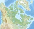
Location map of Canada
ਫ਼ਾਈਲ ਦਾ ਅਤੀਤ
ਫ਼ਾਈਲ ਦੀ ਵਰਤੋਂ
ਇਹ ਫਾਈਲ ਹੇਠਾਂ ਦਿੱਤੇ 2 ਸਫ਼ੇ ਵਰਤਦੇ ਹਨ:
ਫ਼ਾਈਲ ਦੀ ਵਿਆਪਕ ਵਰਤੋਂ
ਇਸ ਫ਼ਾਈਲ ਨੂੰ ਹੋਰ ਹੇਠ ਲਿਖੇ ਵਿਕੀ ਵਰਤਦੇ ਹਨ:
- af.wikipedia.org ਉੱਤੇ ਵਰਤੋਂ
- azb.wikipedia.org ਉੱਤੇ ਵਰਤੋਂ
- ban.wikipedia.org ਉੱਤੇ ਵਰਤੋਂ
- ca.wikipedia.org ਉੱਤੇ ਵਰਤੋਂ
- en.wikipedia.org ਉੱਤੇ ਵਰਤੋਂ
ਇਸ ਫ਼ਾਈਲ ਦੀ ਹੋਰ ਵਿਆਪਕ ਵਰਤੋਂ ਵੇਖੋ।
ਇਸ ਫ਼ਾਈਲ ਵਿੱਚ ਵਾਧੂ ਜਾਣਕਾਰੀਆਂ ਹਨ, ਜੋ ਸ਼ਾਇਦ ਉਸ ਕੈਮਰੇ ਜਾਂ ਸਕੈਨਰ ਦੀ ਦੇਣ ਹਨ ਜੋ ਇਸਨੂੰ ਬਣਾਉਣ ਲਈ ਵਰਤਿਆ ਗਿਆ। ਜੇ ਇਸ ਫ਼ਾਈਲ ਵਿੱਚ ਕੋਈ ਤਬਦੀਲੀ ਕੀਤੀ ਗਈ ਹੈ ਤਾਂ ਹੋ ਸਕਦਾ ਹੈ ਕੁਝ ਵੇਰਵੇ ਬਦਲੀ ਫ਼ਾਈਲ ਦਾ ਸਹੀ ਰੂਪਮਾਨ ਨਾ ਹੋਣ।


