
ਤਸਵੀਰ:Deforestation in Malaysian Borneo.jpg
ਇਸ ਝਾਤ ਦਾ ਅਕਾਰ: 800 × 600 ਪਿਕਸਲ. ਹੋਰ ਰੈਜ਼ੋਲਿਊਸ਼ਨਜ਼: 320 × 240 ਪਿਕਸਲ | 640 × 480 ਪਿਕਸਲ | 1,024 × 768 ਪਿਕਸਲ | 1,280 × 960 ਪਿਕਸਲ | 2,400 × 1,800 ਪਿਕਸਲ.
ਅਸਲ ਫ਼ਾਈਲ (2,400 × 1,800 ਪਿਕਸਲ, ਫ਼ਾਈਲ ਅਕਾਰ: 1.47 MB, MIME ਕਿਸਮ: image/jpeg)
ਸਾਰ
| ਵੇਰਵਾ |
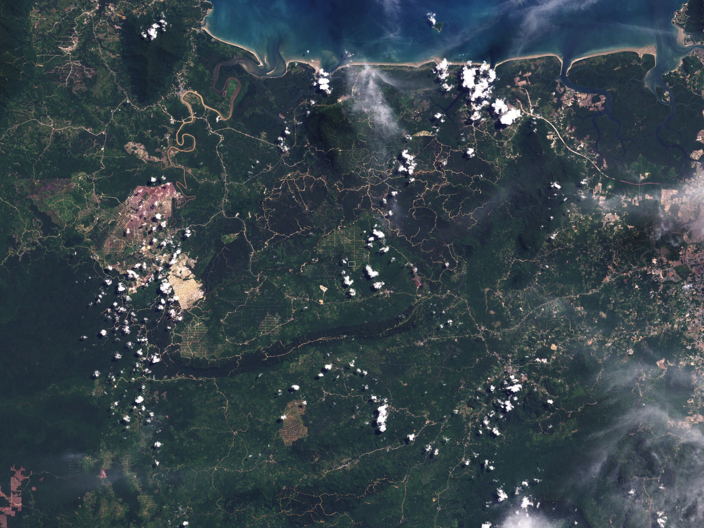
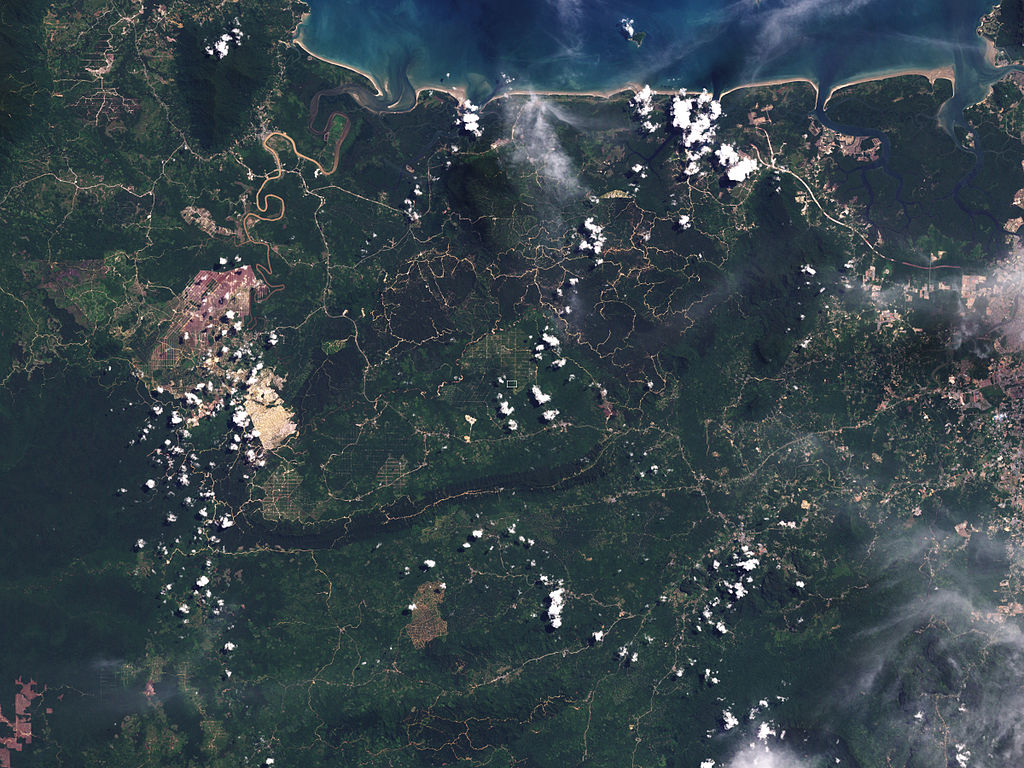
English: The image has a resolution of 30 meters per pixel. Spanning about 22,000 meters, this image shows the difference between plantation and intact forest in part of Malaysian Borneo. The greens of the plantation are paler than those of the surrounding forest, and paths or roads criss-cross the groves. The image reveals the overall extent of land-cover change throughout the region. |
| ਮਿਤੀ | |
| ਸਰੋਤ | NASA Earth Observatory |
| ਲਿਖਾਰੀ | Jesse Allen and Robert Simmon |
Instrument: Landsat 7 - ETM+
ਲਸੰਸ
| This file is in the public domain in the United States because it was solely created by NASA. NASA copyright policy states that "NASA material is not protected by copyright unless noted". (See Template:PD-USGov, NASA copyright policy page or JPL Image Use Policy.) | ||
 |
Warnings:
|
| Annotations | This image is annotated: View the annotations at Commons |
ਫ਼ਾਈਲ ਦਾ ਅਤੀਤ
ਤਾਰੀਖ/ਸਮੇਂ ’ਤੇ ਕਲਿੱਕ ਕਰੋ ਤਾਂ ਉਸ ਸਮੇਂ ਦੀ ਫਾਈਲ ਪੇਸ਼ ਹੋ ਜਾਵੇਗੀ।
| ਮਿਤੀ/ਸਮਾਂ | ਨਮੂਨਾ | ਨਾਪ | ਵਰਤੋਂਕਾਰ | ਟਿੱਪਣੀ | |
|---|---|---|---|---|---|
| ਮੌਜੂਦਾ | 09:11, 10 ਸਤੰਬਰ 2009 | | 2,400 × 1,800 (1.47 MB) | Originalwana | {{Information |Description={{en|1=The image has a resolution of 30 meters per pixel. Spanning about 22,000 meters, this image shows the difference between plantation and intact forest in part of Malaysian Borneo. The greens of the |
ਫ਼ਾਈਲ ਦੀ ਵਰਤੋਂ
ਇਹ ਫਾਈਲ ਹੇਠਾਂ ਦਿੱਤਾ ਸਫ਼ਾ ਵਰਤਦਾ ਹੈ:
ਫ਼ਾਈਲ ਦੀ ਵਿਆਪਕ ਵਰਤੋਂ
ਇਸ ਫ਼ਾਈਲ ਨੂੰ ਹੋਰ ਹੇਠ ਲਿਖੇ ਵਿਕੀ ਵਰਤਦੇ ਹਨ:
- en.wikipedia.org ਉੱਤੇ ਵਰਤੋਂ
- es.wikipedia.org ਉੱਤੇ ਵਰਤੋਂ
- fa.wikipedia.org ਉੱਤੇ ਵਰਤੋਂ
- fr.wikipedia.org ਉੱਤੇ ਵਰਤੋਂ
- ms.wikipedia.org ਉੱਤੇ ਵਰਤੋਂ
- pl.wikipedia.org ਉੱਤੇ ਵਰਤੋਂ