
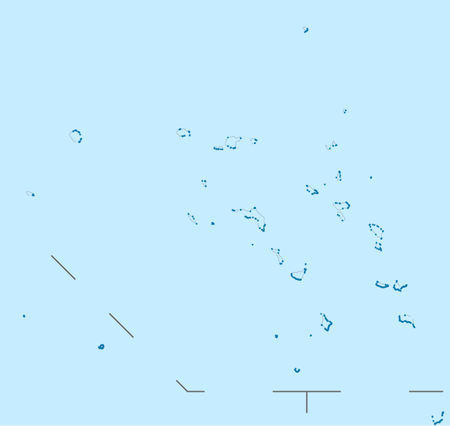
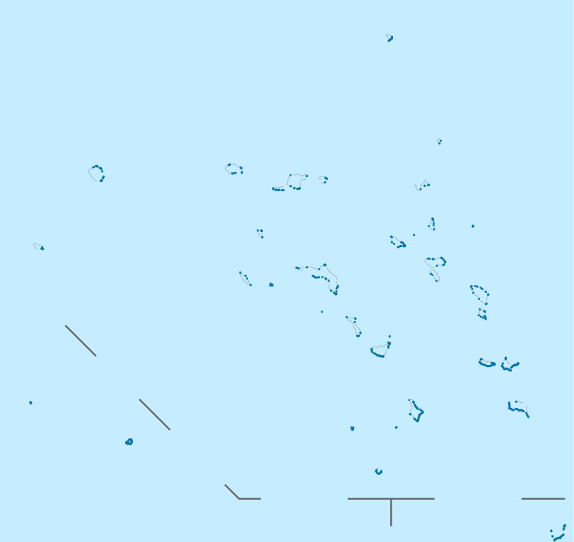
ਤਸਵੀਰ:Marshall Islands location map.svg

Size of this PNG preview of this SVG file: 634 × 600 ਪਿਕਸਲ. ਹੋਰ ਰੈਜ਼ੋਲਿਊਸ਼ਨਜ਼: 254 × 240 ਪਿਕਸਲ | 507 × 480 ਪਿਕਸਲ | 812 × 768 ਪਿਕਸਲ | 1,082 × 1,024 ਪਿਕਸਲ | 2,165 × 2,048 ਪਿਕਸਲ | 780 × 738 ਪਿਕਸਲ.
ਅਸਲ ਫ਼ਾਈਲ (SVG ਫ਼ਾਈਲ, ਆਮ ਤੌਰ ’ਤੇ 780 × 738 ਪਿਕਸਲ, ਫ਼ਾਈਲ ਦਾ ਅਕਾਰ: 101 KB)
ਸਾਰ
| ਵੇਰਵਾ |
Deutsch: Positionskarte der Marshallinseln
Quadratische Plattkarte. Geographische Begrenzung der Karte:
English: Location map of the Marshall Islands
Equirectangular projection. Geographic limits of the map:
|
| ਮਿਤੀ | |
| ਸਰੋਤ |
own work, using
|
| ਲਿਖਾਰੀ | NordNordWest |

|
This map has been made or improved in the German Kartenwerkstatt (Map Lab). You can propose maps to improve as well.
|
ਲਸੰਸ
I, the copyright holder of this work, hereby publish it under the following licenses:

|
ਇਸ ਸਫ਼ੇ ਨੂੰ ਗਨੂ ਲਸੰਸ, ਵਰਜ਼ਨ 1.2 ਜਾਂ ਫਰੀ ਸਾਫਟਵੇਅਰ ਫਾਊਂਡੇਸ਼ਨ ਦੁਆਰਾ ਪ੍ਰਕਾਸ਼ਿਤ ਕੀਤੇ ਨਵੇਂ ਵਰਜ਼ਨ ਤਹਿਤ ਕਾਪੀ ਕਰਨ, ਵੰਡਣ ਜਾਂ/ਅਤੇ ਤਬਦੀਲੀ ਕਰਨ ਦੀ ਖੁੱਲ ਹੈ; ਬਿਨਾ ਕਿਸੇ ਸਥਿਰ ਫਰੰਟ-ਕਵਰ ਜਾਂ ਬੈਕ ਕਵਰ ਲਿਖਤਾਂ ਤੋਂ ਬਿਨਾਂ। ਇਸ ਲਸੰਸ ਦੀ ਇੱਕ ਕਾਪੀ ਇਸ ਗਨੂ ਫਰੀ ਲਸੰਸ ਭਾਗ ਵਿੱਚ ਮੌਜੂਦ ਹੈ। |
This file is licensed under the Creative Commons Attribution 3.0 Unported license.
- ਤੁਹਾਨੂੰ ਖੁੱਲ੍ਹ ਹੈ:
- ਸਾਂਝਾ ਕਰਨ ਦੀ – ਰਚਨਾ ਨੂੰ ਕਾਪੀ, ਵੰਡਣਾ ਅਤੇ ਭੇਜਣਾ
- ਮੁੜ-ਰਲ਼ਾਉਣ ਦੀ – ਰਚਨਾ ਨੂੰ ਢਾਲਣਾ
- ਥੱਲੇ ਲਿਖੀਆਂ ਸ਼ਰਤਾਂ ਹੇਠ:
- ਗੁਣਾਂ ਦੀ ਦੱਸ – ਉਚਿਤ ਕ੍ਰੈਡਿਟ ਦੇਵੋ, ਲਾਇਸੰਸ ਦਾ ਇੱਕ ਲਿੰਕ ਪ੍ਰਦਾਨ ਕਰੋ ਅਤੇ ਇਹ ਦਰਸਾਓ ਕਿ ਕੀ ਤਬਦੀਲੀਆਂ ਕੀਤੀਆਂ ਗਈਆਂ ਸਨ। ਤੁਸੀਂ ਇਹ ਕਿਸੇ ਵੀ ਵਾਜਬ ਤਰੀਕੇ ਨਾਲ ਕਰ ਸਕਦੇ ਹੋ, ਪਰ ਇਹ ਤਰੀਕਾ ਅਜਿਹਾ ਨਹੀਂ ਹੋਣਾ ਚਾਹੀਦਾ ਜੋ ਇਹ ਦਰਸਾਵੇ ਕਿ ਲਾਇਸੰਸਕਰਤਾ ਤੁਹਾਨੂੰ ਜਾਂ ਤੁਹਾਡੀ ਵਰਤੋਂ ਦਾ ਸਮਰਥਨ ਕਰਦਾ ਹੈ।
ਤੁਸੀਂ ਆਪਣੀ ਮਰਜ਼ੀ ਦਾ ਲਸੰਸ ਚੁਣ ਸਕਦੇ ਹੋ।
ਫ਼ਾਈਲ ਦਾ ਅਤੀਤ
ਤਾਰੀਖ/ਸਮੇਂ ’ਤੇ ਕਲਿੱਕ ਕਰੋ ਤਾਂ ਉਸ ਸਮੇਂ ਦੀ ਫਾਈਲ ਪੇਸ਼ ਹੋ ਜਾਵੇਗੀ।
| ਮਿਤੀ/ਸਮਾਂ | ਨਮੂਨਾ | ਨਾਪ | ਵਰਤੋਂਕਾਰ | ਟਿੱਪਣੀ | |
|---|---|---|---|---|---|
| ਮੌਜੂਦਾ | 19:02, 16 ਨਵੰਬਰ 2011 | | 780 × 738 (101 KB) | NordNordWest | upd |
| 10:33, 17 ਅਪਰੈਲ 2009 |  | 780 × 738 (105 KB) | NordNordWest | {{Information |Description= {{de|Positionskarte der Marshallinseln}} Quadratische Plattkarte. Geographische Begrenzung der Karte: * N: 15.5° N * S: 3.0° N * W: 160.0° O * O: 173.2° O {{en|Location map of the [[:en:Marshall Islan |
ਫ਼ਾਈਲ ਦੀ ਵਰਤੋਂ
ਇਹ ਫਾਈਲ ਹੇਠਾਂ ਦਿੱਤਾ ਸਫ਼ਾ ਵਰਤਦਾ ਹੈ:
ਫ਼ਾਈਲ ਦੀ ਵਿਆਪਕ ਵਰਤੋਂ
ਇਸ ਫ਼ਾਈਲ ਨੂੰ ਹੋਰ ਹੇਠ ਲਿਖੇ ਵਿਕੀ ਵਰਤਦੇ ਹਨ:
- af.wikipedia.org ਉੱਤੇ ਵਰਤੋਂ
- an.wikipedia.org ਉੱਤੇ ਵਰਤੋਂ
- ar.wikipedia.org ਉੱਤੇ ਵਰਤੋਂ
- ast.wikipedia.org ਉੱਤੇ ਵਰਤੋਂ
- Mayuru
- Roi-Namur
- Módulu:Mapa de llocalización/datos/Islles Márxal
- Atolón de Kwajalein
- Cadena Ralik
- Atolón d'Ailinginae
- Islla Jabat
- Atolón Ebon
- Islla de Lib
- Atolón d'Enewetak
- Atolón de Lae
- Atolón de Jaluit
- Atolón de Namdrik
- Atolón de Namu
- Atolón de Rongerik
- Atolón de Rongelap
- Islla de Kili
- Atolón de Wotho
- Atolón d'Ujae
- Atolón d'Ujelang
- Atolón d'Arno
- Atolón d'Aur
- Atolón de Bokak
- Atolón d'Erikub
- Atolón de Nadikdik
- Pasaxe de Klee
- Islla de Jemo
- Atolón de Bikar
- Islla de Mejit
- Atolón de Wotje
- Atolón de Toke
- Atolón de Likiep
- Atolón d'Ailuk
- Atolón de Maloelap
- Atolón d'Utirik
- Atolón d'Ailinglaplap
- Atolón de Mili
- Runit
- Delap-Uliga-Djarrit
- Aeropuertu Internacional Amata Kabua
- Aeropuertu del Atolón Bikini
- Módulu:Mapa de llocalización/datos/Islles Márxal/usu
- az.wikipedia.org ਉੱਤੇ ਵਰਤੋਂ
- ba.wikipedia.org ਉੱਤੇ ਵਰਤੋਂ
ਇਸ ਫ਼ਾਈਲ ਦੀ ਹੋਰ ਵਿਆਪਕ ਵਰਤੋਂ ਵੇਖੋ।