ਸਮੱਗਰੀ 'ਤੇ ਜਾਓ

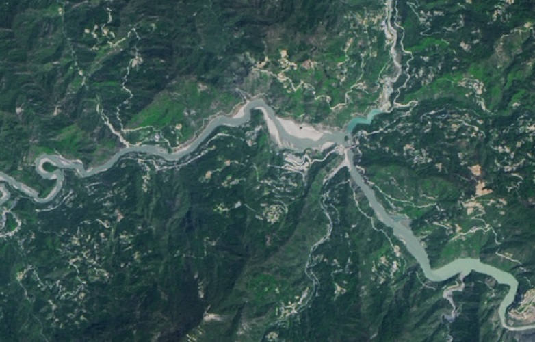
ਤਸਵੀਰ:Tangjiashan Lake 2018 Landsat.jpg

ਸਫ਼ਾ ਸਮੱਗਰੀ ਹੋਰ ਭਾਸ਼ਾਵਾਂ ਵਿੱਚ ਸਹਾਇਕ ਨਹੀ ਹੈ।
ਵਿਕੀਪੀਡੀਆ, ਇੱਕ ਆਜ਼ਾਦ ਵਿਸ਼ਵਕੋਸ਼ ਤੋਂ

Tangjiashan_Lake_2018_Landsat.jpg (782 × 500 ਪਿਕਸਲ, ਫ਼ਾਈਲ ਅਕਾਰ: 138 KB, MIME ਕਿਸਮ: image/jpeg)

ਇਹ ਫ਼ਾਈਲ Wikimedia Commons ਦੀ ਹੈ ਅਤੇ ਹੋਰ ਪਰਿਯੋਜਨਾਵਾਂ ਵਿੱਚ ਵੀ ਵਰਤੀ ਜਾ ਸਕਦੀ ਹੈ । ਇਸ ਫ਼ਾਈਲ ਦੇ ਵੇਰਵਾ ਸਫ਼ੇ ਵਿੱਚ ਮੌਜੂਦ ਵੇਰਵਾ ਹੇਠ ਦਿਸ ਰਿਹਾ ਹੈ।

ਸਾਰ

ਵੇਰਵਾ
English: Tangjiashan Lake on 2018 Landsat imagery
中文(简体):唐家山堰塞湖2018
ਮਿਤੀ
ਸਰੋਤ
The Landsat satellite pictures are used for this image. The data came from Global Land Cover Facility (GLCF), and are processed with Kashmir 3D.
この画像には、ランドサット衛星画像が用いられています。これは、メリーランド大学 / Global Land Cover Facility 所蔵のデータにより、カシミール3Dにより画像化したものです。
ਲਿਖਾਰੀ NASA
Camera location31° 51′ 27″ N, 104° 24′ 57.96″ E Kartographer map based on OpenStreetMap.View this and other nearby images on: OpenStreetMapinfo

ਲਸੰਸ

Public domain This file is in the public domain in the United States because it was solely created by NASA. NASA copyright policy states that "NASA material is not protected by copyright unless noted". (See Template:PD-USGov, NASA copyright policy page or JPL Image Use Policy.)
Warnings:

ਸੁਰਖੀ

Add a one-line explanation of what this file represents

Items portrayed in this file

ਚਿਤਰਨ

28 ਅਪਰੈਲ 2018

coordinates of the point of view ਅੰਗਰੇਜ਼ੀ

31°51'27.0"N, 104°24'58.0"E

checksum ਅੰਗਰੇਜ਼ੀ

33b0443b0169d74d4b652d0b5f809367c99eac96

determination method or standard ਅੰਗਰੇਜ਼ੀ: SHA-1

1,41,363 ਬਾਈਟ

height ਅੰਗਰੇਜ਼ੀ

500 ਪਿਕਸਲ

width ਅੰਗਰੇਜ਼ੀ

782 ਪਿਕਸਲ

ਫ਼ਾਈਲ ਦਾ ਅਤੀਤ

ਤਾਰੀਖ/ਸਮੇਂ ’ਤੇ ਕਲਿੱਕ ਕਰੋ ਤਾਂ ਉਸ ਸਮੇਂ ਦੀ ਫਾਈਲ ਪੇਸ਼ ਹੋ ਜਾਵੇਗੀ।

ਮਿਤੀ/ਸਮਾਂਨਮੂਨਾਨਾਪਵਰਤੋਂਕਾਰਟਿੱਪਣੀ
ਮੌਜੂਦਾ09:30, 27 ਸਤੰਬਰ 201809:30, 27 ਸਤੰਬਰ 2018 ਵੇਲੇ ਦੇ ਵਰਜਨ ਦਾ ਅੰਗੂਠਾਕਾਰ ਰੂਪ782 × 500 (138 KB)PieceofmetalworkUser created page with UploadWizard

ਇਹ ਫਾਈਲ ਹੇਠਾਂ ਦਿੱਤਾ ਸਫ਼ਾ ਵਰਤਦਾ ਹੈ:

ਫ਼ਾਈਲ ਦੀ ਵਿਆਪਕ ਵਰਤੋਂ

ਇਸ ਫ਼ਾਈਲ ਨੂੰ ਹੋਰ ਹੇਠ ਲਿਖੇ ਵਿਕੀ ਵਰਤਦੇ ਹਨ:

ਮੈਟਾਡੈਟਾ