
ਤਸਵੀਰ:Txu-pclmaps-oclc-22834566 f-10a.jpg

ਇਸ ਝਾਤ ਦਾ ਅਕਾਰ: 800 × 591 ਪਿਕਸਲ. ਹੋਰ ਰੈਜ਼ੋਲਿਊਸ਼ਨਜ਼: 320 × 237 ਪਿਕਸਲ | 640 × 473 ਪਿਕਸਲ | 1,024 × 757 ਪਿਕਸਲ | 1,280 × 946 ਪਿਕਸਲ | 2,560 × 1,893 ਪਿਕਸਲ | 9,565 × 7,072 ਪਿਕਸਲ.
ਅਸਲ ਫ਼ਾਈਲ (9,565 × 7,072 ਪਿਕਸਲ, ਫ਼ਾਈਲ ਅਕਾਰ: 19.23 MB, MIME ਕਿਸਮ: image/jpeg)
ਸਾਰ
| ਵੇਰਵਾ |
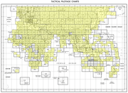
English: Tactical Pilotage Chart Series - World 1:500,000 Scale |
| ਮਿਤੀ |
Compiled: April 1986 AIR INFORMATION CURRENT THROUGH: 9 JUNE 1986 Lithographed by DMAAC: 10-90 University of Texas at Austin: SEP 1991 Scanned: 2011-09-21 05:19:56 |
| ਸਰੋਤ | (Archived) |
| ਲਿਖਾਰੀ | Defense Mapping Agency |
-
 Index Map

ਲਸੰਸ
This work is in the public domain in the United States because it is a work prepared by an officer or employee of the United States Government as part of that person’s official duties under the terms of Title 17, Chapter 1, Section 105 of the US Code.
Note: This only applies to original works of the Federal Government and not to the work of any individual U.S. state, territory, commonwealth, county, municipality, or any other subdivision. This template also does not apply to postage stamp designs published by the United States Postal Service since 1978. (See § 313.6(C)(1) of Compendium of U.S. Copyright Office Practices). It also does not apply to certain US coins; see The US Mint Terms of Use.
|
 | |
| This file has been identified as being free of known restrictions under copyright law, including all related and neighboring rights. | ||
ਫ਼ਾਈਲ ਦਾ ਅਤੀਤ
ਤਾਰੀਖ/ਸਮੇਂ ’ਤੇ ਕਲਿੱਕ ਕਰੋ ਤਾਂ ਉਸ ਸਮੇਂ ਦੀ ਫਾਈਲ ਪੇਸ਼ ਹੋ ਜਾਵੇਗੀ।
| ਮਿਤੀ/ਸਮਾਂ | ਨਮੂਨਾ | ਨਾਪ | ਵਰਤੋਂਕਾਰ | ਟਿੱਪਣੀ | |
|---|---|---|---|---|---|
| ਮੌਜੂਦਾ | 10:35, 27 ਦਸੰਬਰ 2019 | | 9,565 × 7,072 (19.23 MB) | Geographyinitiative | User created page with UploadWizard |
ਫ਼ਾਈਲ ਦੀ ਵਰਤੋਂ
ਇਹ ਫਾਈਲ ਹੇਠਾਂ ਦਿੱਤਾ ਸਫ਼ਾ ਵਰਤਦਾ ਹੈ:
ਫ਼ਾਈਲ ਦੀ ਵਿਆਪਕ ਵਰਤੋਂ
ਇਸ ਫ਼ਾਈਲ ਨੂੰ ਹੋਰ ਹੇਠ ਲਿਖੇ ਵਿਕੀ ਵਰਤਦੇ ਹਨ:
- en.wikipedia.org ਉੱਤੇ ਵਰਤੋਂ
- en.wiktionary.org ਉੱਤੇ ਵਰਤੋਂ