
ਤਸਵੀਰ:USGS magnitude 8 earthquakes since 1900.svg

Size of this PNG preview of this SVG file: 512 × 512 ਪਿਕਸਲ. ਹੋਰ ਰੈਜ਼ੋਲਿਊਸ਼ਨਜ਼: 240 × 240 ਪਿਕਸਲ | 480 × 480 ਪਿਕਸਲ | 768 × 768 ਪਿਕਸਲ | 1,024 × 1,024 ਪਿਕਸਲ | 2,048 × 2,048 ਪਿਕਸਲ.
ਅਸਲ ਫ਼ਾਈਲ (SVG ਫ਼ਾਈਲ, ਆਮ ਤੌਰ ’ਤੇ 512 × 512 ਪਿਕਸਲ, ਫ਼ਾਈਲ ਦਾ ਅਕਾਰ: 112 KB)
ਸਾਰ
| ਵੇਰਵਾ |
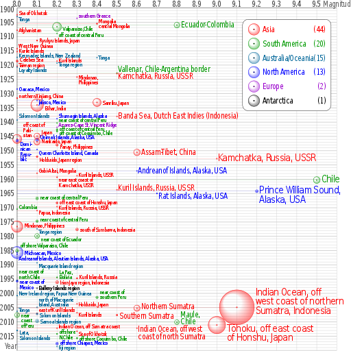
English: Earthquakes of moment magnitude 8.0 and greater from 1900 to 2018. The apparent 3D volumes of the bubbles are linearly proportional to their respective fatalities, i.e. their radii are linearly proportional to the cube root of the fatalities. Data is from https://earthquake.usgs.gov/earthquakes/eqarchives/year/mag8/magnitude8_1900_date.php ; The colour indicates the continent, and the legend counts the number of quakes for each. Notice the absence of Africa and the low presence of Antarctica and Europe. |
| ਸਰੋਤ | ਆਪਣਾ ਕੰਮ |
| ਲਿਖਾਰੀ | Cmglee |
| SVG genesis | This vector image was created with perl. This file uses embedded text that can be easily translated using a text editor. |
| Source code | PERL codetest
Perl script to create above; please do not remove.
#!/usr/bin/perl
$data_string = qq`
as|1902/06/11 05:|50.00|148.00|8.0||Sea of Okhotsk|-8
oc|1903/01/04 05:07|-20.00|-175.00|8.0||Tonga|8
eu|1903/08/11 04:32|36.36|22.97|8.3||southern Greece|-10
as|1905/07/09 09:40|49.0|99.0|8.4||Mongolia|-10
as|1905/07/23 02:46|49.0|98.0|8.4||central Mongolia|8
sa|1906/01/31 15:36|1.0|-81.5|8.8|1000|Colombia-Ecuador||Ecuador-Colombia
sa|1906/08/17 00:40|-33.0|-72.0|8.2|3882|Valparaiso, Chile|5|Valparaiso,Chile
as|1907/10/21 04:23|38.00|69.00|8.0||Afghanistan
sa|1908/12/12 12:08|-14.0|-78.0|8.2||off the coast of central Peru|5|off coast of central Peru
as|1911/06/15 14:26|28.0|130.0|8.1|12|Ryukyu Islands, Japan
as|1914/05/26 14:22|-2.|137.|8.0||West New Guinea|-10
as|1915/05/01 05:00|47.|155.|8.0||Kurile Islands|-4
oc|1917/05/01 18:26|-29.0|-177.0|8.0||Kermadec Islands, New Zealand|-8
oc|1917/06/26 05:49|-15.0|-173.0|8.4||Tonga
as|1918/08/15 12:18|5.653|123.563|8.0|50|Celebes Sea|-5
as|1918/09/07 17:16|45.5|151.5|8.2||Kuril Islands|-4
oc|1919/04/30 07:17|-19.823|-172.215|8.2||Tonga region|5
as|1920/06/05 04:21|23.5|122.0|8.0||Taiwan region|-5
oc|1920/09/20 14:39|-20.0|168.0|8.0||Loyalty Islands|10
sa|1922/11/11 04:32|-28.553|-70.755|8.5||Chile-Argentina Border|-12|Vallenar, Chile-Argentina border
as|1923/02/03 16:01|54.0|161.0|8.5||Kamchatka|10|Kamchatka, Russia, USSR
as|1924/04/14 16:20|7.023|125.954|8.3||Mindanao, Philippines||Mindanao,~Philippines
na|1928/06/17 03:19|16.33|-96.7|8.0||Oaxaca, Mexico
as|1931/08/10 21:18|47.1|89.8|8.0|5|northern Xinjiang, China|-8
na|1932/06/03 10:36|19.84|-103.99|8.1||Jalisco, Mexico|5
as|1933/03/02 17:31|39.22|144.62|8.4|2990|Sanriku, Japan
as|1934/01/15 08:43|27.55|87.09|8.1|10700|Bihar, India|10
as|1938/02/01 19:04|-5.05|131.62|8.5||Banda Sea||Banda Sea, Dutch East Indies (Indonesia)
na|1938/11/10 20:18|55.33|-158.37|8.2||Shumagin Islands, Alaska|-12
oc|1939/04/30 02:55|-10.5|158.5|8.0||Solomon Islands|-15
sa|1940/05/24 16:33|-10.5|-77.0|8.2||near the Coast of central Peru|-12|near coast of central Peru
eu|1941/11/25 18:03|37.171|-18.960|8.2||Azores-Cape St. Vincent Ridge|-10
sa|1942/08/24 22:50|-15.0|-76.0|8.2|30|Off the coast of central Peru|-3|off coast of central Peru
sa|1943/04/06 16:07|-30.75|-72.0|8.2|18|off the coast of Coquimbo, Chile|5|off coast of Coquimbo, Chile
as|1944/12/07 04:35|33.75|136.00|8.1|1223|Tonankai, Japan|-15|Japan
as|1945/11/27 21:57|24.5|63.0|8.0|4000|off the coast of Pakistan|-50|off coast of~Paki-~stan
na|1946/04/01 12:28|52.75|-163.50|8.1|165|Unimak Islands, Alaska|-10|Unimak Islands, Alaska, USA
na|1946/08/04 17:51|19.25|-69.00|8.0|100|Dominican Republic|10|Domi-~nican~Repu-~blic
as|1946/12/20 19:19|32.5|134.5|8.1|1330|Nankaido, Japan|-2
as|1948/01/24 17:46|10.5|122.0|8.2|72|Panay, Philippines|5
na|1949/08/22 04:01|53.62|-133.27|8.1||Queen Charlotte Island, B.C., Canada|10|Queen Charlotte Island, Canada
as|1950/08/15 14:09|28.5|96.5|8.6|1526|Assam-Tibet||Assam-Tibet, China
as|1952/03/04 01:22|42.5|143.0|8.1|31|Hokkaido, Japan region|10
as|1952/11/04 16:58|52.76|160.06|9.0||Kamchatka, Russia||Kamchatka, Russia, USSR
na|1957/03/09 14:22|51.56|-175.39|8.6||Andreanof Islands, Alaska||Andreanof Islands, Alaska, USA
as|1957/12/04 03:37|45.15|99.21|8.1||Gobi-Altai, Mongolia|-10
as|1958/11/06 22:58|44.329|148.623|8.3||Kuril Islands|-3|Kuril Islands, USSR
as|1959/05/04 07:15|53.351|159.645|8.2|1|near the east coast of Kamchatka|8|near east coast of~Kamchatka, USSR
sa|1960/05/22 19:11|-38.29|-73.05|9.5|1655|Chile
as|1963/10/13 05:17|44.9|149.6|8.5||Kuril Islands|-5|Kuril Islands, Russia, USSR
na|1964/03/28 03:36|61.02|-147.65|9.2|125|Prince William Sound, Alaska||Prince William Sound,~Alaska, USA
na|1965/02/04 05:01|51.21|-178.50|8.7|5|Rat Islands, Alaska|10|Rat Islands, Alaska, USA
sa|1966/10/17 21:41|-10.807|-78.684|8.1|125|near the coast of central Peru|-5|near coast of central Peru
as|1968/05/16 00:49|40.903|143.346|8.2|47|off the east coast of Honshu, Japan|-4|off east coast of Honshu, Japan
as|1969/08/11 21:27|43.478|147.815|8.2||Kuril Islands|2|Kuril Islands, Russia, USSR
sa|1970/07/31 17:08|-1.49|-72.56|8.0||Colombia|-8
as|1971/01/10 07:17|-3.132|139.697|8.1||Papua, Indonesia|5
sa|1974/10/03 14:21|-12.254|-77.524|8.1|78|near the coast of central Peru|-7|near coast of central Peru
as|1976/08/16 16:11|6.292|124.090|8.0|8000|Mindanao, Philippines|-5
oc|1977/06/22 12:08|-22.878|-175.900|8.1||Tonga region|8
as|1977/08/19 06:08|-11.085|118.464|8.3|100|south of Sumbawa, Indonesia
sa|1979/12/12 07:59|1.598|-79.358|8.1|600|near the coast of Ecuador|10|near coast of Ecuador
sa|1985/03/03 22:47|-33.135|-71.871|8.0|177|offshore Valparaiso, Chile|-20
na|1985/09/19 13:17|18.190|-102.533|8.0|9500|Michoacan, Mexico
na|1986/05/07 22:47|51.520|-174.776|8.0||Andreanof Islands, Aleutian Islands, Alaska|15|Andreanof Islands, Aleutian Islands, Alaska, USA
oc|1989/05/23 10:54|-52.341|160.568|8.1||Macquarie Island region|10
sa|1994/06/09 00:33|-13.841|-67.553|8.2|5|La Paz, Bolivia|-20|La Paz,~Bolivia
as|1994/10/04 13:22|43.773|147.321|8.3|11|Kuril Islands|-5|Kuril Islands, Russia
sa|1995/07/30 05:11|-23.340|-70.294|8.0|3|Near Coast of Northern Chile|-32|near coast of~north Chile
na|1995/10/09 15:35|19.055|-104.205|8.0|49|Near Coast of Jalisco, Mexico|2|near coast of~Mexico
as|1996/02/17 05:59|-0.891|136.952|8.2|166|Irian Jaya region, Indonesia
an|1998/03/25 03:12|-62.877|149.527|8.1||Balleny Islands region|-2
oc|2000/11/16 04:54|-3.980|152.169|8.0|2|New Ireland region, Papua New Guinea|-8
sa|2001/06/23 20:33|-16.264|-73.641|8.4|75|near the coast of southern Peru|-20|near coast of~southern Peru
as|2003/09/25 19:50|41.815|143.910|8.3||Hokkaido, Japan region||Hokkaido, Japan
oc|2004/12/23 14:59|-49.312|161.345|8.1||north of Macquarie Island|-28|north of Macquarie~Island, Australia
as|2004/12/26 00:58|3.295|95.982|9.1|227898|off the west coast of northern Sumatra|-50|Indian Ocean, off~west coast of northern~Sumatra, Indonesia
as|2005/03/28 16:09|2.074|97.013|8.6|1313|Northern Sumatra, Indonesia|-5|Northern Sumatra
oc|2006/05/03 15:26|-20.187|-174.123|8.0||Tonga|-5
as|2006/11/15 11:14|46.592|153.226|8.3||Kuril Islands|5
as|2007/01/13 04:23:21|46.243|154.524|8.1||East of the Kuril Islands|-13|east of Kuril Islands
oc|2007/04/01 20:39:58|-8.466|157.043|8.1|34|Solomon Islands|5
sa|2007/08/15 23:40:57|-13.386|-76.603|8.0|650|Near the Coast of Central Peru||near~coast~of Peru
as|2007/09/12 11:10:26|-4.438|101.367|8.5|25|Southern Sumatra, Indonesia|5|Southern Sumatra
oc|2009/09/29 17:48:10|-15.489|-172.095|8.1|192|Samoa Islands region|0
sa|2010/02/27 06:34:14|-35.846|-72.719|8.8|577|Offshore Maule, Chile|-25|Maule,~Chile
as|2011/03/11 05:46:23|38.322|142.369|9.0|28050|Near the East Coast of Honshu, Japan|15|Tōhoku, off east coast~of Honshu, Japan
as|2012/04/11 08:38:37|2.311|93.063|8.6||off the west coast of northern Sumatra|5|Indian Ocean, off west~coast of north Sumatra
as|2012/04/11 10:43:09|0.773|92.452|8.2||off the west coast of northern Sumatra|-7|Indian Ocean, off Sumatra coast
oc|2013/02/06 01:12:27|-10.738|165.138|8.0|13|Lata,~Solomon Islands|7|
as|2013/05/24 06:44:49|54.874|153.281|8.3||Sea of Okhotsk|7|
sa|2014/04/01 23:46:47|-19.642|-70.817|8.2|6|offshore~N.Chile|-7|
sa|2015/09/16 22:54|-31.570|-71.654|8.3|14|offshore Coquimbo, Chile
na|2017/09/08 04:49|15.022|-93.899|8.2|98|offshore Chiapas, Mexico|-3
oc|2018/08/19 00:19|-18.178|-178.111|8.2|0|Fiji region|4
`;
%continents = (
"na" => { "colour" => "#0000ff", "count" => 0, "name" => "North America" },
"sa" => { "colour" => "#009900", "count" => 0, "name" => "South America" },
"eu" => { "colour" => "#9900cc", "count" => 0, "name" => "Europe" },
"af" => { "colour" => "#996600", "count" => 0, "name" => "Africa" },
"as" => { "colour" => "#ff0000", "count" => 0, "name" => "Asia" },
"oc" => { "colour" => "#006699", "count" => 0, "name" => "Australia/Oceania" },
"an" => { "colour" => "#000000", "count" => 0, "name" => "Antarctica" },
undef);
@continent_order = ("as", "sa", "oc", "na", "eu", "an", "af");
# @continent_order = ("na","sa", "eu", "af", "as", "oc", "an");
$mag_min = 8; $mag_max = 9.6; $date_min = 1900; $date_max = 2020;
$x_min = 0; $x_max = &x($mag_max); $y_min = 0; $y_max = &y($date_max);
$x_legend = 790; $y_legend = 40; $w_legend = 310; $h_legend = 320;
$x_viewbox = -60; $y_viewbox = -28; $width_viewbox = 1230; $height_viewbox = 1230;
$out_graph = $out_legend = $out_grid = $out_grad = "";
$x_margin = &x($mag_min);
sub year_fraction {
($y, $m, $d) = split(/\//, $_[0]);
# $y = $_[0];
# $m = $_[1] || 1;
# $d = $_[2] || 1;
$is_leap_year = $y % 100 ? ($y % 4 == 0) : ($y % 400 == 0);
$day_of_year = int($d - ($m < 3 ? 30 : $is_leap_year ? 31 : 32) + 30.56 * $m);
return $y + ($day_of_year - 1) / ($is_leap_year ? 366 : 365);
}
sub x { return sprintf("%.3f", 700 * ($_[0] - $mag_min)); }
sub y { return sprintf("%d", 10 * ($_[0] - $date_min)); }
$double_dash = "-" . "-";
$file_out = $0; $file_out =~ s/[^\.]*$/svg/;
@data = split(/\n/, $data_string);
foreach (@data) {
if ($_ && substr($_, 0, 1) ne "#") {
($continent, $datetime, $latitude, $longitude, $magnitude, $fatalities, $region, $label_offset, $label) = split(/\|/, $_);
if ($magnitude >= $mag_min) {
print "$continent\t$datetime\t$latitude\t$longitude\t$magnitude\t$fatalities\t$region\t$label_offset\t$label\n";
($date, $time) = split(/\s/, $datetime);
$x = &x($magnitude);
$y = &y(&year_fraction($date));
$r = $fatalities ** (1 / 3);
$x_label = $x + $r + 4;
$y_label = $y + $label_offset + 8;
$colour = $continents{$continent}{"colour"};
++$continents{$continent}{"count"};
if ($label eq "") { $label = $region; }
if ($label =~ m/~/) {
$label =~ s`~`</tspan><tspan x="0" dy="0.9em">`g;
$label = qq`<tspan>${label}</tspan>`;
}
$font_size = $magnitude < 8.5 ? qq` font-size="20"` :
($magnitude >= 9 ? qq` font-size="36"` : qq``);
$out_graph .= qq`
<g stroke="${colour}" fill="${colour}">
<text transform="translate(${x_label},${y_label}) scale(0.8,1)" x="0" y="0"${font_size} stroke="none">${label}</text>
<circle cx="${x}" cy="${y}" r="${r}" fill="url(#grad_${continent})"/>
<circle cx="${x}" cy="${y}" r="2" fill-opacity="0.5"/>
<path d="M ${x} ${y} H ${x_margin}" stroke-width="0.5" stroke-opacity="0.5"/>
</g>`;
}
}
}
$y = 35;
foreach (@continent_order) {
$count = $continents{$_}{"count"};
if ($count > 0) {
$colour = $continents{$_}{"colour"};
$name = $continents{$_}{"name"};
$out_grad .= qq`
<radialGradient id="grad_${_}" cx="50%" cy="50%" r="50%" fx="25%" fy="25%">
<stop offset="50%" stop-color="${colour}" stop-opacity="0"/>
<stop offset="100%" stop-color="${colour}" stop-opacity="0.5"/>
</radialGradient>`;
$out_legend .= qq`
<text transform="translate(70,${y}) scale(0.8,1)" x="0" y="10" fill="${colour}"><tspan>${name}</tspan><tspan x="280" text-anchor="end">(${count})</tspan></text>
<circle cx="40" cy="${y}" r="20" stroke="${colour}" fill="url(#grad_${_})"/>
<circle cx="40" cy="${y}" r="2" stroke="${colour}"/>`;
$y += 50;
}
}
for ($mag = $mag_max; $mag >= $mag_min; $mag -= 0.1) {
$x = &x($mag);
$mag = sprintf("%0.1f", $mag);
$out_grid .= qq`
<use xlink:href="#grid_x" transform="translate(${x},0)"/>`;
if ($mag < $mag_max) {
$out_grid .= qq`
<text transform="translate(${x},-5) scale(0.8,1)" x="0" y="0" text-anchor="middle">${mag}</text>`;
}
}
for ($date = $date_max; $date >= $date_min; $date -= 5) {
$y = &y($date);
if ($date > $date_min) {
$out_grid .= qq`
<use xlink:href="#grid_y_5" transform="translate(0,${y})"/>`;
if ($date < $date_max) {
$out_grid .= qq`
<text transform="translate(-5,${y}) scale(0.8,1)" x="0" y="10" text-anchor="end">${date}</text>`;
}
} else {
$out_grid .= qq`
<text transform="translate(-5,${y}) scale(0.8,1)" x="0" y="15" text-anchor="end">${date}</text>`;
}
}
open (FILE_OUT, ">$file_out");
print FILE_OUT qq`<?xml version="1.0" encoding="utf-8"?>
<svg xmlns="http://www.w3.org/2000/svg" xmlns:xlink="http://www.w3.org/1999/xlink" width="100%" height="100%" viewBox="${x_viewbox} ${y_viewbox} ${width_viewbox} ${height_viewbox}">
<title>Magnitude 8.0 and greater earthquakes since 1900</title>
<desc>Earthquakes of moment magnitude 8.0 and greater since 1900, charted by CMG Lee. The apparent 3D volumes of the bubbles are linearly proportional to their respective fatalities, i.e. their radii are linearly proportional to the cube root of the fatalities. Data is from https://earthquake.usgs.gov/earthquakes/eqarchives/year/mag8/magnitude8_1900_date.php , http://comcat.cr.usgs.gov/earthquakes/eventpage/usc000f1s0 and http://comcat.cr.usgs.gov/earthquakes/eventpage/usb000h4jh .</desc>
<defs>${out_grad}
<path id="grid_x" d="M 0 ${y_min} V ${y_max}"/>
<path id="grid_y" d="M ${x_min} 0 h -1 H ${x_max}"/>
<path id="grid_y_tick" d="M ${x_min} 0 h -2 H ${x_max}" stroke-width="2"/>
<g id="grid_y_5">
<use xlink:href="#grid_y_tick"/>
<use xlink:href="#grid_y" transform="translate(0,-10)"/>
<use xlink:href="#grid_y" transform="translate(0,-20)"/>
<use xlink:href="#grid_y" transform="translate(0,-30)"/>
<use xlink:href="#grid_y" transform="translate(0,-40)"/>
</g>
</defs>
<rect x="${x_viewbox}" y="${y_viewbox}" width="${width_viewbox}" height="${height_viewbox}" fill="#ffffff"/>
<g font-family="sans-serif" letter-spacing="-2" font-size="28" text-anchor="start">
<g stroke="#cccccc" fill="#000000">${out_grid}
<path d="M 0 ${y_max} V 0 H ${x_max}" stroke="#000000" fill="none"/>
</g>
<g transform="scale(0.8,1)" fill="#666666">
<text x="-55" y="1195">Year</text>
<text x="1340" y="-5">Magnitude</text>
</g>
<g transform="translate(${x_legend},${y_legend})">
<rect x="0" y="0" width="${w_legend}" height="${h_legend}" rx="20" ry="20" stroke="#000000" fill="#ffffff"/>${out_legend}
</g>
${out_graph}
</g>
</svg>
<!${double_dash} Perl script to create above; please do not remove.
`;
open (FILE_IN, $0);
while (<FILE_IN>) { print FILE_OUT $_; }
close FILE_IN;
print FILE_OUT "# ${double_dash}>";
close FILE_OUT;
#
|
This vector image was created with perl by v.
ਲਸੰਸ
I, the copyright holder of this work, hereby publish it under the following licenses:
ਇਸ ਫ਼ਾਈਲ ਦਾ ਲਸੰਸ ਕ੍ਰਿਏਟਿਵ ਕਾਮਨਜ਼ ਐਟ੍ਰੀਬਿਊਸ਼ਨ-ਸ਼ੇਅਰ ਅਲਾਈਕ 3.0 ਅਨਪੋਰਟੇਡ ਹੈ।
- ਤੁਹਾਨੂੰ ਖੁੱਲ੍ਹ ਹੈ:
- ਸਾਂਝਾ ਕਰਨ ਦੀ – ਰਚਨਾ ਨੂੰ ਕਾਪੀ, ਵੰਡਣਾ ਅਤੇ ਭੇਜਣਾ
- ਮੁੜ-ਰਲ਼ਾਉਣ ਦੀ – ਰਚਨਾ ਨੂੰ ਢਾਲਣਾ
- ਥੱਲੇ ਲਿਖੀਆਂ ਸ਼ਰਤਾਂ ਹੇਠ:
- ਗੁਣਾਂ ਦੀ ਦੱਸ – ਉਚਿਤ ਕ੍ਰੈਡਿਟ ਦੇਵੋ, ਲਾਇਸੰਸ ਦਾ ਇੱਕ ਲਿੰਕ ਪ੍ਰਦਾਨ ਕਰੋ ਅਤੇ ਇਹ ਦਰਸਾਓ ਕਿ ਕੀ ਤਬਦੀਲੀਆਂ ਕੀਤੀਆਂ ਗਈਆਂ ਸਨ। ਤੁਸੀਂ ਇਹ ਕਿਸੇ ਵੀ ਵਾਜਬ ਤਰੀਕੇ ਨਾਲ ਕਰ ਸਕਦੇ ਹੋ, ਪਰ ਇਹ ਤਰੀਕਾ ਅਜਿਹਾ ਨਹੀਂ ਹੋਣਾ ਚਾਹੀਦਾ ਜੋ ਇਹ ਦਰਸਾਵੇ ਕਿ ਲਾਇਸੰਸਕਰਤਾ ਤੁਹਾਨੂੰ ਜਾਂ ਤੁਹਾਡੀ ਵਰਤੋਂ ਦਾ ਸਮਰਥਨ ਕਰਦਾ ਹੈ।
- ਸ਼ੇਅਰ ਅਲਾਈਕ – ਜੇਕਰ ਤੁਸੀਂ ਸਮੱਗਰੀ ਨੂੰ ਰੀਮਿਕਸ ਕਰਦੇ ਹੋ, ਬਦਲਦੇ ਹੋ ਜਾਂ ਬਣਾਉਂਦੇ ਹੋ, ਤਾਂ ਆਪਣੇ ਯੋਗਦਾਨ ਇੱਕੋ ਜਿਹੇ ਜਾਂ ਅਨੁਕੂਲ ਲਾਇਸੰਸ ਦੇ ਅਧੀਨ ਕਰੋ।

|
ਇਸ ਸਫ਼ੇ ਨੂੰ ਗਨੂ ਲਸੰਸ, ਵਰਜ਼ਨ 1.2 ਜਾਂ ਫਰੀ ਸਾਫਟਵੇਅਰ ਫਾਊਂਡੇਸ਼ਨ ਦੁਆਰਾ ਪ੍ਰਕਾਸ਼ਿਤ ਕੀਤੇ ਨਵੇਂ ਵਰਜ਼ਨ ਤਹਿਤ ਕਾਪੀ ਕਰਨ, ਵੰਡਣ ਜਾਂ/ਅਤੇ ਤਬਦੀਲੀ ਕਰਨ ਦੀ ਖੁੱਲ ਹੈ; ਬਿਨਾ ਕਿਸੇ ਸਥਿਰ ਫਰੰਟ-ਕਵਰ ਜਾਂ ਬੈਕ ਕਵਰ ਲਿਖਤਾਂ ਤੋਂ ਬਿਨਾਂ। ਇਸ ਲਸੰਸ ਦੀ ਇੱਕ ਕਾਪੀ ਇਸ ਗਨੂ ਫਰੀ ਲਸੰਸ ਭਾਗ ਵਿੱਚ ਮੌਜੂਦ ਹੈ। |
ਤੁਸੀਂ ਆਪਣੀ ਮਰਜ਼ੀ ਦਾ ਲਸੰਸ ਚੁਣ ਸਕਦੇ ਹੋ।
ਫ਼ਾਈਲ ਦਾ ਅਤੀਤ
ਤਾਰੀਖ/ਸਮੇਂ ’ਤੇ ਕਲਿੱਕ ਕਰੋ ਤਾਂ ਉਸ ਸਮੇਂ ਦੀ ਫਾਈਲ ਪੇਸ਼ ਹੋ ਜਾਵੇਗੀ।
| ਮਿਤੀ/ਸਮਾਂ | ਨਮੂਨਾ | ਨਾਪ | ਵਰਤੋਂਕਾਰ | ਟਿੱਪਣੀ | |
|---|---|---|---|---|---|
| ਮੌਜੂਦਾ | 07:53, 7 ਅਕਤੂਬਰ 2018 | | 512 × 512 (112 KB) | JoKalliauer | Inkscape: --verb=SelectionUnGroup (inkscape --verb=EditSelectAll --verb=SelectionUnGroup --verb=SelectionUnGroup --verb=SelectionUnGroup --verb=SelectionUnGroup --verb=SelectionUnGroup --verb=FileSave --verb=FileClose ./${file}u.svg --verb=FileQuit) |
| 22:04, 6 ਅਕਤੂਬਰ 2018 |  | 512 × 512 (40 KB) | JoKalliauer | try to simplify file | |
| 18:47, 5 ਅਕਤੂਬਰ 2018 |  | 512 × 512 (61 KB) | Cmglee | Try to fix bubbles. | |
| 18:18, 4 ਅਕਤੂਬਰ 2018 |  | 512 × 512 (61 KB) | Cmglee | Update up to 2018-10-04. | |
| 23:21, 2 ਅਪਰੈਲ 2015 |  | 512 × 512 (60 KB) | Cmglee | Add 2014 quake, axis labels (w:user_talk:cmglee#Earthquake_graph) and minor cosmetic changes. | |
| 12:13, 3 ਜੁਲਾਈ 2013 |  | 512 × 512 (60 KB) | Cmglee | Add 2013 quakes and minor cosmetic changes. | |
| 22:48, 13 ਅਪਰੈਲ 2012 |  | 512 × 512 (59 KB) | Cmglee | Add counts to legend and refine more labels. | |
| 22:09, 13 ਅਪਰੈਲ 2012 |  | 512 × 512 (59 KB) | Cmglee | Refine labels. | |
| 21:16, 13 ਅਪਰੈਲ 2012 |  | 512 × 512 (58 KB) | Cmglee | Add magnitude 8.0 to 8.4 earthquakes to match filename. | |
| 19:24, 13 ਅਪਰੈਲ 2012 |  | 512 × 512 (23 KB) | Cmglee | Shorten label to fit. |
ਫ਼ਾਈਲ ਦੀ ਵਰਤੋਂ
ਇਹ ਫਾਈਲ ਹੇਠਾਂ ਦਿੱਤਾ ਸਫ਼ਾ ਵਰਤਦਾ ਹੈ:
ਫ਼ਾਈਲ ਦੀ ਵਿਆਪਕ ਵਰਤੋਂ
ਇਸ ਫ਼ਾਈਲ ਨੂੰ ਹੋਰ ਹੇਠ ਲਿਖੇ ਵਿਕੀ ਵਰਤਦੇ ਹਨ:
- am.wikipedia.org ਉੱਤੇ ਵਰਤੋਂ
- ar.wikipedia.org ਉੱਤੇ ਵਰਤੋਂ
- en.wikipedia.org ਉੱਤੇ ਵਰਤੋਂ
- fa.wikipedia.org ਉੱਤੇ ਵਰਤੋਂ
- gl.wikipedia.org ਉੱਤੇ ਵਰਤੋਂ
- hu.wikipedia.org ਉੱਤੇ ਵਰਤੋਂ
- id.wikipedia.org ਉੱਤੇ ਵਰਤੋਂ
- ko.wikipedia.org ਉੱਤੇ ਵਰਤੋਂ
- mnw.wikipedia.org ਉੱਤੇ ਵਰਤੋਂ
- ms.wikipedia.org ਉੱਤੇ ਵਰਤੋਂ
- pt.wikipedia.org ਉੱਤੇ ਵਰਤੋਂ
- tr.wikipedia.org ਉੱਤੇ ਵਰਤੋਂ
- uk.wikipedia.org ਉੱਤੇ ਵਰਤੋਂ
- zh.wikipedia.org ਉੱਤੇ ਵਰਤੋਂ