
ਤਸਵੀਰ:United Nations (Member States).svg

Size of this PNG preview of this SVG file: 800 × 406 ਪਿਕਸਲ. ਹੋਰ ਰੈਜ਼ੋਲਿਊਸ਼ਨਜ਼: 320 × 162 ਪਿਕਸਲ | 640 × 325 ਪਿਕਸਲ | 1,024 × 520 ਪਿਕਸਲ | 1,280 × 650 ਪਿਕਸਲ | 2,560 × 1,300 ਪਿਕਸਲ | 2,754 × 1,398 ਪਿਕਸਲ.
ਅਸਲ ਫ਼ਾਈਲ (SVG ਫ਼ਾਈਲ, ਆਮ ਤੌਰ ’ਤੇ 2,754 × 1,398 ਪਿਕਸਲ, ਫ਼ਾਈਲ ਦਾ ਅਕਾਰ: 1.05 MB)
.svg)
ਸਾਰ
| ਵੇਰਵਾ |
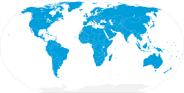
English: Map showing the UN member states
UN Member States UN Observer States Non-Member States and Non-Self-Governing Territories Antarctica (international territory)
Español: Mapa mostrando los países miembros de la ONU
Estados miembros de la ONU Países observadores de la ONU Estados no miembros y territorios no autónomos Antártida (territorio internacional) |
| ਮਿਤੀ | |
| ਸਰੋਤ |
Own work based on:
|
| ਲਿਖਾਰੀ | M.Bitton |
| Other versions |
United Nations (Member States and Territories).svg, with dots for territories and non-member states Meant to replace United Nations Members.svg, which is buggy |
| SVG genesis | This world map was created with a text editor. |
.svg)
ਲਸੰਸ
I, the copyright holder of this work, hereby publish it under the following license:
This file is licensed under the Creative Commons Attribution-Share Alike 4.0 International license.
- ਤੁਹਾਨੂੰ ਖੁੱਲ੍ਹ ਹੈ:
- ਸਾਂਝਾ ਕਰਨ ਦੀ – ਰਚਨਾ ਨੂੰ ਕਾਪੀ, ਵੰਡਣਾ ਅਤੇ ਭੇਜਣਾ
- ਮੁੜ-ਰਲ਼ਾਉਣ ਦੀ – ਰਚਨਾ ਨੂੰ ਢਾਲਣਾ
- ਥੱਲੇ ਲਿਖੀਆਂ ਸ਼ਰਤਾਂ ਹੇਠ:
- ਗੁਣਾਂ ਦੀ ਦੱਸ – ਉਚਿਤ ਕ੍ਰੈਡਿਟ ਦੇਵੋ, ਲਾਇਸੰਸ ਦਾ ਇੱਕ ਲਿੰਕ ਪ੍ਰਦਾਨ ਕਰੋ ਅਤੇ ਇਹ ਦਰਸਾਓ ਕਿ ਕੀ ਤਬਦੀਲੀਆਂ ਕੀਤੀਆਂ ਗਈਆਂ ਸਨ। ਤੁਸੀਂ ਇਹ ਕਿਸੇ ਵੀ ਵਾਜਬ ਤਰੀਕੇ ਨਾਲ ਕਰ ਸਕਦੇ ਹੋ, ਪਰ ਇਹ ਤਰੀਕਾ ਅਜਿਹਾ ਨਹੀਂ ਹੋਣਾ ਚਾਹੀਦਾ ਜੋ ਇਹ ਦਰਸਾਵੇ ਕਿ ਲਾਇਸੰਸਕਰਤਾ ਤੁਹਾਨੂੰ ਜਾਂ ਤੁਹਾਡੀ ਵਰਤੋਂ ਦਾ ਸਮਰਥਨ ਕਰਦਾ ਹੈ।
- ਸ਼ੇਅਰ ਅਲਾਈਕ – ਜੇਕਰ ਤੁਸੀਂ ਸਮੱਗਰੀ ਨੂੰ ਰੀਮਿਕਸ ਕਰਦੇ ਹੋ, ਬਦਲਦੇ ਹੋ ਜਾਂ ਬਣਾਉਂਦੇ ਹੋ, ਤਾਂ ਆਪਣੇ ਯੋਗਦਾਨ ਇੱਕੋ ਜਿਹੇ ਜਾਂ ਅਨੁਕੂਲ ਲਾਇਸੰਸ ਦੇ ਅਧੀਨ ਕਰੋ।
ਫ਼ਾਈਲ ਦਾ ਅਤੀਤ
ਤਾਰੀਖ/ਸਮੇਂ ’ਤੇ ਕਲਿੱਕ ਕਰੋ ਤਾਂ ਉਸ ਸਮੇਂ ਦੀ ਫਾਈਲ ਪੇਸ਼ ਹੋ ਜਾਵੇਗੀ।
.svg&dir=prev)
.svg&offset=20220704060959)
.svg&offset=&limit=20)
.svg&offset=&limit=50)
.svg&offset=&limit=100)
.svg&offset=&limit=250)
.svg&offset=&limit=500)
| ਮਿਤੀ/ਸਮਾਂ | ਨਮੂਨਾ | ਨਾਪ | ਵਰਤੋਂਕਾਰ | ਟਿੱਪਣੀ | |
|---|---|---|---|---|---|
| ਮੌਜੂਦਾ | 02:38, 9 ਜੁਲਾਈ 2022 | | 2,754 × 1,398 (1.05 MB) | Kwamikagami | comment out mouseover names of Kosovo, N.Cyprus, Somaliland etc., which are not rec by UN |
| 16:52, 6 ਜੁਲਾਈ 2022 |  | 2,754 × 1,398 (1.05 MB) | M.Bitton | Different colour for the observer States | |
| 00:20, 5 ਜੁਲਾਈ 2022 |  | 2,754 × 1,398 (1.05 MB) | M.Bitton | Optimized for readability | |
| 22:09, 4 ਜੁਲਾਈ 2022 |  | 2,754 × 1,398 (1.05 MB) | Kwamikagami | m | |
| 21:53, 4 ਜੁਲਾਈ 2022 |  | 2,754 × 1,398 (1.05 MB) | Kwamikagami | touch up grey > blue, consistent circle size | |
| 18:15, 4 ਜੁਲਾਈ 2022 |  | 2,754 × 1,398 (1.05 MB) | M.Bitton | Reverted to version as of 14:06, 4 July 2022 (UTC): there really is no need to change the base map | |
| 18:02, 4 ਜੁਲਾਈ 2022 |  | 2,756 × 1,399 (814 KB) | Newfraferz87 | Using more compact & customizable template from here, will this work better? | |
| 14:06, 4 ਜੁਲਾਈ 2022 |  | 2,754 × 1,398 (1.05 MB) | M.Bitton | Optimized for readability | |
| 13:41, 4 ਜੁਲਾਈ 2022 |  | 2,754 × 1,398 (1.05 MB) | M.Bitton | Updated | |
| 06:09, 4 ਜੁਲਾਈ 2022 |  | 2,754 × 1,398 (1.05 MB) | Kwamikagami | Use national names for decolonized areas (Puerto Rico, Guadeloupe, Bonaire, etc.) |
ਫ਼ਾਈਲ ਦੀ ਵਰਤੋਂ
ਇਸ ਫ਼ਾਈਲ ਦੀ ਵਰਤੋਂ ਕਰਨ ਵਾਲੇ ਕੋਈ ਪੰਨੇ ਨਹੀਂ ਹਨ।
ਫ਼ਾਈਲ ਦੀ ਵਿਆਪਕ ਵਰਤੋਂ
ਇਸ ਫ਼ਾਈਲ ਨੂੰ ਹੋਰ ਹੇਠ ਲਿਖੇ ਵਿਕੀ ਵਰਤਦੇ ਹਨ:
- ar.wikipedia.org ਉੱਤੇ ਵਰਤੋਂ
- en.wikipedia.org ਉੱਤੇ ਵਰਤੋਂ
- es.wikipedia.org ਉੱਤੇ ਵਰਤੋਂ
- fr.wikipedia.org ਉੱਤੇ ਵਰਤੋਂ
- mai.wikipedia.org ਉੱਤੇ ਵਰਤੋਂ
- mn.wikipedia.org ਉੱਤੇ ਵਰਤੋਂ
- nds-nl.wikipedia.org ਉੱਤੇ ਵਰਤੋਂ
- pl.wiktionary.org ਉੱਤੇ ਵਰਤੋਂ
- pt.wikipedia.org ਉੱਤੇ ਵਰਤੋਂ
- so.wikipedia.org ਉੱਤੇ ਵਰਤੋਂ
- tr.wikipedia.org ਉੱਤੇ ਵਰਤੋਂ
- uk.wikipedia.org ਉੱਤੇ ਵਰਤੋਂ
.svg)