
ਤਸਵੀਰ:2017-04 Circumpolar trails sunset at La Hague lighthouse.jpg

ਇਸ ਝਾਤ ਦਾ ਅਕਾਰ: 800 × 450 ਪਿਕਸਲ. ਹੋਰ ਰੈਜ਼ੋਲਿਊਸ਼ਨਜ਼: 320 × 180 ਪਿਕਸਲ | 640 × 360 ਪਿਕਸਲ | 1,024 × 576 ਪਿਕਸਲ | 1,280 × 720 ਪਿਕਸਲ | 2,560 × 1,440 ਪਿਕਸਲ | 5,944 × 3,344 ਪਿਕਸਲ.
ਅਸਲ ਫ਼ਾਈਲ (5,944 × 3,344 ਪਿਕਸਲ, ਫ਼ਾਈਲ ਅਕਾਰ: 9.65 MB, MIME ਕਿਸਮ: image/jpeg)
ਸਾਰ
| ਵੇਰਵਾ |
Français : Photographie circumpolaire (réalisé par empilage de lumière d'environ 250 photos, chacune exposé 30s, ce qui équivaut à une exposition de 2h05) au phare de la Hague, France.
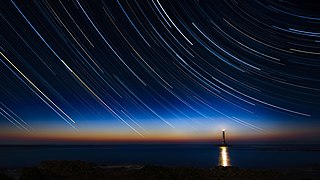
English: Circumpolar stars in star trails (made with a light-stacking of 250 photos, each exposed 30s, which is equivalent to a 2h05 exposed photo) at the La Hague lighthouse, France.
Español: Senderos de estrellas circumpolares y faro de La Hague, Normandía, Francia. Imagen producida con una compilación de 250 fotos con una exposición de 30 segundos cada una, equivalente a una exposición total de 125 minutos.
Polski: Fotografia gwiazd okołobiegunowych nad latarnią morską La Hague w Normandii, we Francji. Została ona złożona z 250 fotografii, z których każda była naświetlana przez 30 s, co daje łączny czas ekspozycji 2 godz. 5 min.
Українська: Зоряні шляхи циркумполярної області неба (компіляція 250 знімків з витримкою 30 с кожен, загалом 2 години 5 хвилин) поблизу маяка Де ла Хог, Нормандія, Франція.
Čeština: Snímek noční oblohy s expoziční dobou 2 hodiny a 5 minut, zobrazující dráhy cirkumpolárních hvězd nad majákem La Hague lighthouse, Normandie, Francie.
Deutsch: Eine über zwei Stunden belichtete Fotografie von zirkumpolaren Sternen in Sternenspuren am Leuchtturm von La Hague in der Normandie (Frankreich)
Македонски: Движење на ѕвездите на небото над Нормандија. Изложено 2 часа.
Nederlands: Foto van de sterrenhemel boven de vuurtoren in La Hague in de Franse regio Normandië, genomen met een sluitertijd van 2 uur en 5 minuten
Português: Trilhas de estrelas circumpolares em uma fotografia obtida pela exposição de 125 minutos tomada próximo ao farol do Cabo de la Hague, Normandia, França. |
| ਮਿਤੀ | |
| ਸਰੋਤ | ਆਪਣਾ ਕੰਮ |
| ਲਿਖਾਰੀ | Antoine Lamielle |
| Camera location | | View this and other nearby images on: OpenStreetMap |
|---|
| Object location | | View this and other nearby images on: OpenStreetMap |
|---|
Assessment
|

This image was selected as picture of the day on Wikimedia Commons for 24 December 2018. It was captioned as follows: English: 2h05 exposed photo of circumpolar stars in star trails at the La Hague lighthouse, Normandy, France. Other languages:
Čeština: Snímek noční oblohy s expoziční dobou 2 hodiny a 5 minut, zobrazující dráhy cirkumpolárních hvězd nad majákem La Hague lighthouse, Normandie, Francie. Deutsch: Eine über zwei Stunden belichtete Fotografie von zirkumpolaren Sternen in Sternenspuren am Leuchtturm von La Hague in der Normandie (Frankreich) English: 2h05 exposed photo of circumpolar stars in star trails at the La Hague lighthouse, Normandy, France. Español: Senderos de estrellas circumpolares. Foto de larga exposición (125 minutos) tomada cerca del faro de La Hague, Normandía, Francia. Nederlands: Foto van de sterrenhemel boven de vuurtoren in La Hague in de Franse regio Normandië, genomen met een sluitertijd van 2 uur en 5 minuten Polski: Fotografia z czasem ekspozycji 2 godz. 5 min gwiazd okołobiegunowych nad latarnią morską La Hague w Normandii, we Francji. Português: Trilhas de estrelas circumpolares em uma fotografia obtida pela exposição de 125 minutos tomada próximo ao farol do Cabo de la Hague, Normandia, França. Македонски: Движење на ѕвездите на небото над Нормандија. Изложено 2 часа. |
ਲਸੰਸ
I, the copyright holder of this work, hereby publish it under the following license:
This file is licensed under the Creative Commons Attribution-Share Alike 4.0 International license.
- ਤੁਹਾਨੂੰ ਖੁੱਲ੍ਹ ਹੈ:
- ਸਾਂਝਾ ਕਰਨ ਦੀ – ਰਚਨਾ ਨੂੰ ਕਾਪੀ, ਵੰਡਣਾ ਅਤੇ ਭੇਜਣਾ
- ਮੁੜ-ਰਲ਼ਾਉਣ ਦੀ – ਰਚਨਾ ਨੂੰ ਢਾਲਣਾ
- ਥੱਲੇ ਲਿਖੀਆਂ ਸ਼ਰਤਾਂ ਹੇਠ:
- ਗੁਣਾਂ ਦੀ ਦੱਸ – ਉਚਿਤ ਕ੍ਰੈਡਿਟ ਦੇਵੋ, ਲਾਇਸੰਸ ਦਾ ਇੱਕ ਲਿੰਕ ਪ੍ਰਦਾਨ ਕਰੋ ਅਤੇ ਇਹ ਦਰਸਾਓ ਕਿ ਕੀ ਤਬਦੀਲੀਆਂ ਕੀਤੀਆਂ ਗਈਆਂ ਸਨ। ਤੁਸੀਂ ਇਹ ਕਿਸੇ ਵੀ ਵਾਜਬ ਤਰੀਕੇ ਨਾਲ ਕਰ ਸਕਦੇ ਹੋ, ਪਰ ਇਹ ਤਰੀਕਾ ਅਜਿਹਾ ਨਹੀਂ ਹੋਣਾ ਚਾਹੀਦਾ ਜੋ ਇਹ ਦਰਸਾਵੇ ਕਿ ਲਾਇਸੰਸਕਰਤਾ ਤੁਹਾਨੂੰ ਜਾਂ ਤੁਹਾਡੀ ਵਰਤੋਂ ਦਾ ਸਮਰਥਨ ਕਰਦਾ ਹੈ।
- ਸ਼ੇਅਰ ਅਲਾਈਕ – ਜੇਕਰ ਤੁਸੀਂ ਸਮੱਗਰੀ ਨੂੰ ਰੀਮਿਕਸ ਕਰਦੇ ਹੋ, ਬਦਲਦੇ ਹੋ ਜਾਂ ਬਣਾਉਂਦੇ ਹੋ, ਤਾਂ ਆਪਣੇ ਯੋਗਦਾਨ ਇੱਕੋ ਜਿਹੇ ਜਾਂ ਅਨੁਕੂਲ ਲਾਇਸੰਸ ਦੇ ਅਧੀਨ ਕਰੋ।
ਫ਼ਾਈਲ ਦਾ ਅਤੀਤ
ਤਾਰੀਖ/ਸਮੇਂ ’ਤੇ ਕਲਿੱਕ ਕਰੋ ਤਾਂ ਉਸ ਸਮੇਂ ਦੀ ਫਾਈਲ ਪੇਸ਼ ਹੋ ਜਾਵੇਗੀ।
| ਮਿਤੀ/ਸਮਾਂ | ਨਮੂਨਾ | ਨਾਪ | ਵਰਤੋਂਕਾਰ | ਟਿੱਪਣੀ | |
|---|---|---|---|---|---|
| ਮੌਜੂਦਾ | 18:00, 27 ਨਵੰਬਰ 2017 | | 5,944 × 3,344 (9.65 MB) | 0x010C | remove some hotspots and small chromatic aberation |
| 20:53, 22 ਨਵੰਬਰ 2017 |  | 5,944 × 3,344 (9.52 MB) | 0x010C | fix non-vertical lighthouse | |
| 14:15, 21 ਨਵੰਬਰ 2017 |  | 5,545 × 3,119 (7.93 MB) | 0x010C | little perspective correction | |
| 12:59, 9 ਨਵੰਬਰ 2017 |  | 5,944 × 3,344 (9.09 MB) | 0x010C | User created page with UploadWizard |
ਫ਼ਾਈਲ ਦੀ ਵਰਤੋਂ
ਇਸ ਫ਼ਾਈਲ ਦੀ ਵਰਤੋਂ ਕਰਨ ਵਾਲੇ ਕੋਈ ਪੰਨੇ ਨਹੀਂ ਹਨ।
ਫ਼ਾਈਲ ਦੀ ਵਿਆਪਕ ਵਰਤੋਂ
ਇਸ ਫ਼ਾਈਲ ਨੂੰ ਹੋਰ ਹੇਠ ਲਿਖੇ ਵਿਕੀ ਵਰਤਦੇ ਹਨ:
- be-tarask.wikipedia.org ਉੱਤੇ ਵਰਤੋਂ
- bn.wikipedia.org ਉੱਤੇ ਵਰਤੋਂ
- crh.wikipedia.org ਉੱਤੇ ਵਰਤੋਂ
- cs.wikipedia.org ਉੱਤੇ ਵਰਤੋਂ
- cv.wikipedia.org ਉੱਤੇ ਵਰਤੋਂ
- en.wikipedia.org ਉੱਤੇ ਵਰਤੋਂ
- en.wikiquote.org ਉੱਤੇ ਵਰਤੋਂ
- fa.wikipedia.org ਉੱਤੇ ਵਰਤੋਂ
- fr.wikipedia.org ਉੱਤੇ ਵਰਤੋਂ
- hu.wikipedia.org ਉੱਤੇ ਵਰਤੋਂ
- hy.wikipedia.org ਉੱਤੇ ਵਰਤੋਂ
- it.wikipedia.org ਉੱਤੇ ਵਰਤੋਂ
- ka.wikipedia.org ਉੱਤੇ ਵਰਤੋਂ
- ko.wikipedia.org ਉੱਤੇ ਵਰਤੋਂ
- lbe.wikipedia.org ਉੱਤੇ ਵਰਤੋਂ
- lez.wikipedia.org ਉੱਤੇ ਵਰਤੋਂ
- mk.wikipedia.org ਉੱਤੇ ਵਰਤੋਂ
- os.wikipedia.org ਉੱਤੇ ਵਰਤੋਂ
- pt.wikipedia.org ਉੱਤੇ ਵਰਤੋਂ
- ru.wikipedia.org ਉੱਤੇ ਵਰਤੋਂ
- ru.wikinews.org ਉੱਤੇ ਵਰਤੋਂ
- sah.wikipedia.org ਉੱਤੇ ਵਰਤੋਂ
- tt.wikipedia.org ਉੱਤੇ ਵਰਤੋਂ
- uk.wikipedia.org ਉੱਤੇ ਵਰਤੋਂ
- vep.wikipedia.org ਉੱਤੇ ਵਰਤੋਂ
- vi.wikipedia.org ਉੱਤੇ ਵਰਤੋਂ
- zh.wikipedia.org ਉੱਤੇ ਵਰਤੋਂ
ਇਸ ਫ਼ਾਈਲ ਦੀ ਹੋਰ ਵਿਆਪਕ ਵਰਤੋਂ ਵੇਖੋ।