
ਤਸਵੀਰ:Sani Pass heading into Lesotho.jpg

ਇਸ ਝਾਤ ਦਾ ਅਕਾਰ: 800 × 532 ਪਿਕਸਲ. ਹੋਰ ਰੈਜ਼ੋਲਿਊਸ਼ਨਜ਼: 320 × 213 ਪਿਕਸਲ | 640 × 425 ਪਿਕਸਲ | 1,024 × 680 ਪਿਕਸਲ | 1,280 × 850 ਪਿਕਸਲ | 1,600 × 1,063 ਪਿਕਸਲ.
ਅਸਲ ਫ਼ਾਈਲ (1,600 × 1,063 ਪਿਕਸਲ, ਫ਼ਾਈਲ ਅਕਾਰ: 2.24 MB, MIME ਕਿਸਮ: image/jpeg)
ਸਾਰ
| ਵੇਰਵਾ |
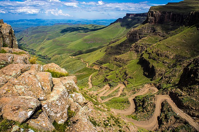
English: The road through Sani Pass taken from the rim of Drakensberg Escarpment within 100 metres of the South African/Lesotho border. |
| ਮਿਤੀ | |
| ਸਰੋਤ | Flickr: Sani Pass |
| ਲਿਖਾਰੀ | Vaiz Ha |
| Camera location | | View this and other nearby images on: OpenStreetMap |
|---|
Geo-coords added by Martinvl after comparison of image with Google Earth.
ਲਸੰਸ
| This image was originally posted to Flickr by Vaiz Ha at https://www.flickr.com/photos/93708644@N05/8523139565. It was reviewed on 11 ਮਾਰਚ 2015 by FlickreviewR and was confirmed to be licensed under the terms of the cc-by-2.0. |
ਇਹ ਫਾਈਲ Creative Commons Attribution 2.0 Generic ਲਸੰਸ ਹੇਠ ਉਪਲੱਬਧ ਹੈ।
ਐਟਰੀਬਿਊਸ਼ਨ: Vaiz Ha
- ਤੁਹਾਨੂੰ ਖੁੱਲ੍ਹ ਹੈ:
- ਸਾਂਝਾ ਕਰਨ ਦੀ – ਰਚਨਾ ਨੂੰ ਕਾਪੀ, ਵੰਡਣਾ ਅਤੇ ਭੇਜਣਾ
- ਮੁੜ-ਰਲ਼ਾਉਣ ਦੀ – ਰਚਨਾ ਨੂੰ ਢਾਲਣਾ
- ਥੱਲੇ ਲਿਖੀਆਂ ਸ਼ਰਤਾਂ ਹੇਠ:
- ਗੁਣਾਂ ਦੀ ਦੱਸ – ਉਚਿਤ ਕ੍ਰੈਡਿਟ ਦੇਵੋ, ਲਾਇਸੰਸ ਦਾ ਇੱਕ ਲਿੰਕ ਪ੍ਰਦਾਨ ਕਰੋ ਅਤੇ ਇਹ ਦਰਸਾਓ ਕਿ ਕੀ ਤਬਦੀਲੀਆਂ ਕੀਤੀਆਂ ਗਈਆਂ ਸਨ। ਤੁਸੀਂ ਇਹ ਕਿਸੇ ਵੀ ਵਾਜਬ ਤਰੀਕੇ ਨਾਲ ਕਰ ਸਕਦੇ ਹੋ, ਪਰ ਇਹ ਤਰੀਕਾ ਅਜਿਹਾ ਨਹੀਂ ਹੋਣਾ ਚਾਹੀਦਾ ਜੋ ਇਹ ਦਰਸਾਵੇ ਕਿ ਲਾਇਸੰਸਕਰਤਾ ਤੁਹਾਨੂੰ ਜਾਂ ਤੁਹਾਡੀ ਵਰਤੋਂ ਦਾ ਸਮਰਥਨ ਕਰਦਾ ਹੈ।

|
This image has been assessed under the valued image criteria and is considered the most valued image on Commons within the scope: Road up the Sani Pass, South Africa heading towards the Lesotho border.. You can see its nomination here. |
ਫ਼ਾਈਲ ਦਾ ਅਤੀਤ
ਤਾਰੀਖ/ਸਮੇਂ ’ਤੇ ਕਲਿੱਕ ਕਰੋ ਤਾਂ ਉਸ ਸਮੇਂ ਦੀ ਫਾਈਲ ਪੇਸ਼ ਹੋ ਜਾਵੇਗੀ।
| ਮਿਤੀ/ਸਮਾਂ | ਨਮੂਨਾ | ਨਾਪ | ਵਰਤੋਂਕਾਰ | ਟਿੱਪਣੀ | |
|---|---|---|---|---|---|
| ਮੌਜੂਦਾ | 21:24, 11 ਮਾਰਚ 2015 | | 1,600 × 1,063 (2.24 MB) | Alifazal | User created page with UploadWizard |
ਫ਼ਾਈਲ ਦੀ ਵਰਤੋਂ
ਇਸ ਫ਼ਾਈਲ ਦੀ ਵਰਤੋਂ ਕਰਨ ਵਾਲੇ ਕੋਈ ਪੰਨੇ ਨਹੀਂ ਹਨ।
ਫ਼ਾਈਲ ਦੀ ਵਿਆਪਕ ਵਰਤੋਂ
ਇਸ ਫ਼ਾਈਲ ਨੂੰ ਹੋਰ ਹੇਠ ਲਿਖੇ ਵਿਕੀ ਵਰਤਦੇ ਹਨ:
- af.wikipedia.org ਉੱਤੇ ਵਰਤੋਂ
- bh.wikipedia.org ਉੱਤੇ ਵਰਤੋਂ
- bn.wikipedia.org ਉੱਤੇ ਵਰਤੋਂ
- ca.wikipedia.org ਉੱਤੇ ਵਰਤੋਂ
- ceb.wikipedia.org ਉੱਤੇ ਵਰਤੋਂ
- de.wikipedia.org ਉੱਤੇ ਵਰਤੋਂ
- en.wikipedia.org ਉੱਤੇ ਵਰਤੋਂ
- Mountain pass
- Sani Pass
- User talk:InfamousArgyle
- User talk:Mathwhiz 29
- User talk:Whiteghost.ink
- User talk:C6541/Archives
- User talk:Sahara4u
- User talk:Sarason
- User talk:Smileguy91
- User talk:Hypoplectrus
- User talk:Pratyya Ghosh
- User talk:Gwooodward
- User talk:Human3015
- User talk:Khamar
- User talk:Joshualouie711
- User talk:OfficialNeon
- User talk:Mozby
- User talk:MoarSmtp
- User talk:VictorTorres2002/Archive 3
- User talk:Mitchellhobbs/Archives/1
- User talk:TheDragonHypothesis
- User talk:Vanilla Wizard/Archive 1
- User talk:VictorTorres2002/Archive 5
- User talk:Esquivalience/Archive 15
- User talk:MusikAnimal/Archive 42
- User talk:ChamithN/Archive 32
- User talk:Winner 42/Archive 25
- User talk:Bananasoldier/Archive 9
- User talk:TruthToBeSpoken/Archive 6
- User talk:CAPTAIN RAJU/Archive 98
- User talk:K6ka/Archive 27
- User talk:Silver seren/Archive 25
- User talk:BabbaQ/Archive 11
- User talk:Mahensingha/Archive 54
- User talk:Sanskari/Archive 109
- User talk:KGirlTrucker81/Signpost/Archive 17
- User talk:Hhkohh/Archive 6
- User talk:7&6=thirteen/Archive 15
- User talk:NorthwestPassage/Archive 5
- Wikipedia talk:Articles for improvement/Archive 24
ਇਸ ਫ਼ਾਈਲ ਦੀ ਹੋਰ ਵਿਆਪਕ ਵਰਤੋਂ ਵੇਖੋ।