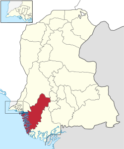
ਠੱਟਾ ਜ਼ਿਲ੍ਹਾ
ਦਿੱਖ
ਠੱਟਾ ਜ਼ਿਲ੍ਹਾ
| |
|---|---|
ਸਿੰਧ ਦਾ ਜ਼ਿਲ੍ਹਾ | |
ਉੱਪਰ: ਕੀਂਝਰ ਝੀਲ ਹੇਠਾਂ: ਭੰਡੋਰ ਕਿਲਾ | |
 | |
| ਦੇਸ਼ | |
| ਪ੍ਰਾਂਤ | ਫਰਮਾ:Country data ਸਿੰਧ |
| ਮੁੱਖ ਦਫਤਰ | ਠੱਟਾ |
| ਖੇਤਰ | |
| • ਕੁੱਲ | 8,570 km2 (3,310 sq mi) |
| ਆਬਾਦੀ | |
| • ਕੁੱਲ | 9,79,817 |
| • ਘਣਤਾ | 110/km2 (300/sq mi) |
| ਸਮਾਂ ਖੇਤਰ | ਯੂਟੀਸੀ+5 (PST) |
| ਤਹਿਸੀਲਾਂ ਦੀ ਗਿਣਤੀ | 7 |
| ਵੈੱਬਸਾਈਟ | [1] |
ਠੱਟਾ ਜ਼ਿਲ੍ਹਾ (ਸਿੰਧੀ: ٺٽو ضلعو, Urdu: ضلع ٹهٹہ) ਪਾਕਿਸਤਾਨ ਦੇ ਸਿੰਧ ਸੂਬੇ ਦੇ ਦੱਖਣੀ ਖੇਤਰ ਵਿੱਚ ਸਥਿਤ ਹੈ, ਜਿਸਨੂੰ ਸਥਾਨਕ ਤੌਰ 'ਤੇ ਲਾਰ ਕਿਹਾ ਜਾਂਦਾ ਹੈ। ਇਸ ਦੀ ਰਾਜਧਾਨੀ ਠੱਟਾ ਹੈ। ਇਹ ਮਕਲੀ ਦੇ ਇੱਕ ਵੱਡੇ ਗਿਰਜਾਘਰ ਦਾ ਘਰ ਹੈ। 2013 ਵਿੱਚ, ਨਵਾਂ ਸੁਜਾਵਲ ਜ਼ਿਲ੍ਹਾ ਬਣਾਉਣ ਲਈ ਕਈ ਤਾਲੁਕਾਂ ਨੂੰ ਵੱਖ ਕੀਤਾ ਗਿਆ ਸੀ।[3]
ਹਵਾਲੇ
[ਸੋਧੋ]- ↑ "Population of Thatta District per 2017 census" (PDF). Pakistan Bureau of Statistics, Government of Pakistan website. Archived from the original (PDF) on 27 January 2018. Retrieved 15 March 2023.
- ↑ ਹਵਾਲੇ ਵਿੱਚ ਗ਼ਲਤੀ:Invalid
<ref>tag; no text was provided for refs namedpopulation - ↑ "Thatta Split to Make Sujawal 28th district of Sindh". Dawn News. Retrieved 15 January 2017.
ਬਿਬਲੀਓਗ੍ਰਾਫੀ
[ਸੋਧੋ]- 1998 District census report of Thatta. Census publication. Vol. 54. Islamabad: Population Census Organization, Statistics Division, Government of Pakistan. 1999.


