
ਤਸਵੀਰ:Map Europe 1923-en.svg

Size of this PNG preview of this SVG file: 800 × 543 ਪਿਕਸਲ. ਹੋਰ ਰੈਜ਼ੋਲਿਊਸ਼ਨਜ਼: 320 × 217 ਪਿਕਸਲ | 640 × 434 ਪਿਕਸਲ | 1,024 × 695 ਪਿਕਸਲ | 1,280 × 869 ਪਿਕਸਲ | 2,560 × 1,738 ਪਿਕਸਲ | 1,037 × 704 ਪਿਕਸਲ.
ਅਸਲ ਫ਼ਾਈਲ (SVG ਫ਼ਾਈਲ, ਆਮ ਤੌਰ ’ਤੇ 1,037 × 704 ਪਿਕਸਲ, ਫ਼ਾਈਲ ਦਾ ਅਕਾਰ: 188 KB)
| ਵੇਰਵਾ |
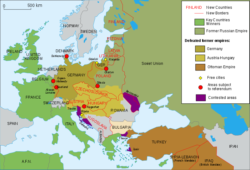
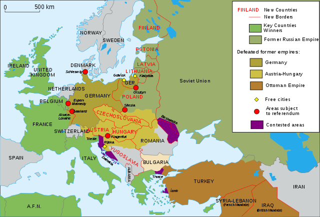
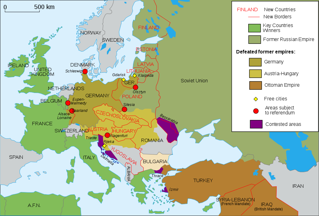
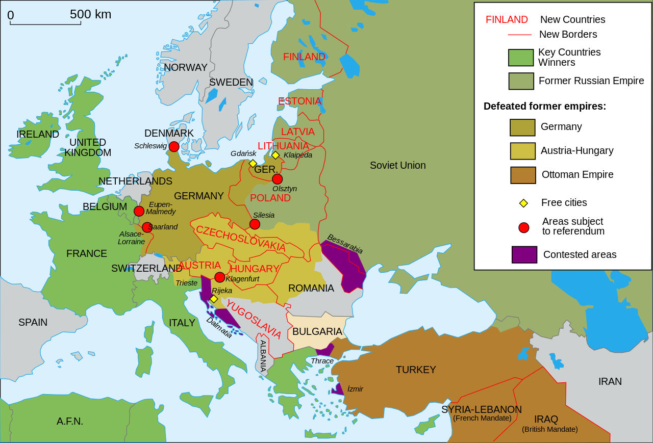
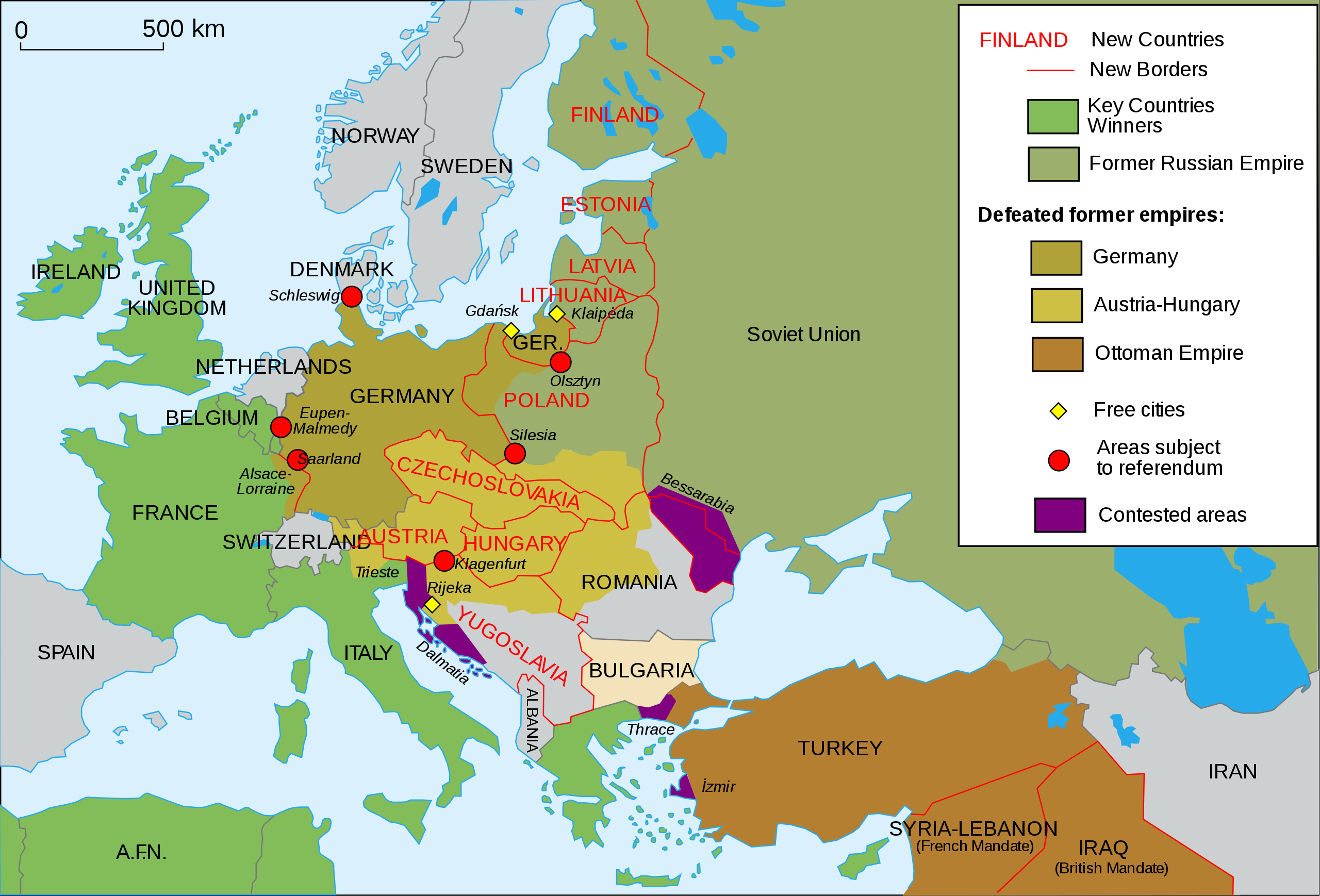
English: Map of Europe and Western Asia in 1923 after World War I Español: Mapa de Europa y Asia en 1923 Français : Carte de l'Europe en 1923. Português: Mapa da Europa e da Ásia em 1923 অসমীয়া: প্ৰথম বিশ্বযুদ্ধৰ পিছত ১৯২৩ চনত ইউৰোপ আৰু পশ্চিম এছিয়াৰ মানচিত্ৰ বাংলা : প্রথম বিশ্বযুদ্ধের পর ১৯২৩ সালে ইউরোপ ও পশ্চিম এশিয়ার মানচিত্র |
| ਮਿਤੀ | (UTC) |
| ਸਰੋਤ | |
| ਲਿਖਾਰੀ |
|
| Other versions |
Derivative works of this file: []
|
| SVG genesis | This vector image was created with Inkscape, or with something else. This file uses embedded text that can be easily translated using a text editor. |


I, the copyright holder of this work, hereby publish it under the following license:
This file is licensed under the Creative Commons Attribution-Share Alike 2.5 Generic, 2.0 Generic and 1.0 Generic license.
- ਤੁਹਾਨੂੰ ਖੁੱਲ੍ਹ ਹੈ:
- ਸਾਂਝਾ ਕਰਨ ਦੀ – ਰਚਨਾ ਨੂੰ ਕਾਪੀ, ਵੰਡਣਾ ਅਤੇ ਭੇਜਣਾ
- ਮੁੜ-ਰਲ਼ਾਉਣ ਦੀ – ਰਚਨਾ ਨੂੰ ਢਾਲਣਾ
- ਥੱਲੇ ਲਿਖੀਆਂ ਸ਼ਰਤਾਂ ਹੇਠ:
- ਗੁਣਾਂ ਦੀ ਦੱਸ – ਉਚਿਤ ਕ੍ਰੈਡਿਟ ਦੇਵੋ, ਲਾਇਸੰਸ ਦਾ ਇੱਕ ਲਿੰਕ ਪ੍ਰਦਾਨ ਕਰੋ ਅਤੇ ਇਹ ਦਰਸਾਓ ਕਿ ਕੀ ਤਬਦੀਲੀਆਂ ਕੀਤੀਆਂ ਗਈਆਂ ਸਨ। ਤੁਸੀਂ ਇਹ ਕਿਸੇ ਵੀ ਵਾਜਬ ਤਰੀਕੇ ਨਾਲ ਕਰ ਸਕਦੇ ਹੋ, ਪਰ ਇਹ ਤਰੀਕਾ ਅਜਿਹਾ ਨਹੀਂ ਹੋਣਾ ਚਾਹੀਦਾ ਜੋ ਇਹ ਦਰਸਾਵੇ ਕਿ ਲਾਇਸੰਸਕਰਤਾ ਤੁਹਾਨੂੰ ਜਾਂ ਤੁਹਾਡੀ ਵਰਤੋਂ ਦਾ ਸਮਰਥਨ ਕਰਦਾ ਹੈ।
- ਸ਼ੇਅਰ ਅਲਾਈਕ – ਜੇਕਰ ਤੁਸੀਂ ਸਮੱਗਰੀ ਨੂੰ ਰੀਮਿਕਸ ਕਰਦੇ ਹੋ, ਬਦਲਦੇ ਹੋ ਜਾਂ ਬਣਾਉਂਦੇ ਹੋ, ਤਾਂ ਆਪਣੇ ਯੋਗਦਾਨ ਇੱਕੋ ਜਿਹੇ ਜਾਂ ਅਨੁਕੂਲ ਲਾਇਸੰਸ ਦੇ ਅਧੀਨ ਕਰੋ।
Original upload log
This image is a derivative work of the following images:
- File:Map_Europe_1923-fr.svg licensed with Cc-by-sa-2.5,2.0,1.0, Cc-by-sa-2.5,2.0,1.0/en
- 2007-04-19T18:31:16Z Bibi Saint-Pol 1037x704 (191242 Bytes) {{Information |Description= {{en|Map of Europe in 1923.}} {{fr|Carte de l'Europe en 1923.}} |Source=Own work |Date=2007-02-16 |Author=[[User:Historicair|Historicair]] |Permission={{self2|GFDL|cc-by-sa-2.5,2.0,1.0}} |other_ver
Uploaded with derivativeFX

|
This SVG file contains embedded text that can be translated into your language, using any capable SVG editor, text editor or the SVG Translate tool. For more information see: About translating SVG files. |
ਫ਼ਾਈਲ ਦਾ ਅਤੀਤ
ਤਾਰੀਖ/ਸਮੇਂ ’ਤੇ ਕਲਿੱਕ ਕਰੋ ਤਾਂ ਉਸ ਸਮੇਂ ਦੀ ਫਾਈਲ ਪੇਸ਼ ਹੋ ਜਾਵੇਗੀ।
| ਮਿਤੀ/ਸਮਾਂ | ਨਮੂਨਾ | ਨਾਪ | ਵਰਤੋਂਕਾਰ | ਟਿੱਪਣੀ | |
|---|---|---|---|---|---|
| ਮੌਜੂਦਾ | 13:42, 11 ਨਵੰਬਰ 2015 | | 1,037 × 704 (188 KB) | Oosterhagen | The Netherlands as neutral |
| 14:24, 15 ਅਗਸਤ 2015 |  | 1,037 × 704 (177 KB) | Fluteflute | Correct misspelling. Sweeden -> Sweden | |
| 16:21, 13 ਜਨਵਰੀ 2009 |  | 1,037 × 704 (187 KB) | Fluteflute | small text changes | |
| 16:17, 13 ਜਨਵਰੀ 2009 |  | 1,037 × 704 (187 KB) | Fluteflute | {{Information |Description={{en|Map of Europe in 1923.}} {{fr|Carte de l'Europe en 1923.}} |Source=*File:Map_Europe_1923-fr.svg |Date=2009-01-13 16:16 (UTC) |Author=*derivative work: ~~~ *File:Map_Europe_1923-fr.svg: [[User:Historicair|Histori |
ਫ਼ਾਈਲ ਦੀ ਵਰਤੋਂ
ਇਹ ਫਾਈਲ ਹੇਠਾਂ ਦਿੱਤਾ ਸਫ਼ਾ ਵਰਤਦਾ ਹੈ:
ਫ਼ਾਈਲ ਦੀ ਵਿਆਪਕ ਵਰਤੋਂ
ਇਸ ਫ਼ਾਈਲ ਨੂੰ ਹੋਰ ਹੇਠ ਲਿਖੇ ਵਿਕੀ ਵਰਤਦੇ ਹਨ:
- af.wikipedia.org ਉੱਤੇ ਵਰਤੋਂ
- ar.wikipedia.org ਉੱਤੇ ਵਰਤੋਂ
- azb.wikipedia.org ਉੱਤੇ ਵਰਤੋਂ
- az.wikipedia.org ਉੱਤੇ ਵਰਤੋਂ
- be-tarask.wikipedia.org ਉੱਤੇ ਵਰਤੋਂ
- ca.wikipedia.org ਉੱਤੇ ਵਰਤੋਂ
- ckb.wikipedia.org ਉੱਤੇ ਵਰਤੋਂ
- cy.wikipedia.org ਉੱਤੇ ਵਰਤੋਂ
- en.wikipedia.org ਉੱਤੇ ਵਰਤੋਂ
- Molotov–Ribbentrop Pact
- Nation state
- Self-determination
- Treaty of Versailles
- Woodrow Wilson
- 20th century
- Flight and expulsion of Germans (1944–1950)
- Balkanization
- Aftermath of World War I
- Revanchism
- Causes of World War II
- Territorial evolution of Russia
- History of Western civilization
- List of irredentist claims or disputes
- World War I
- List of national border changes (1914–present)
- Presidency of Woodrow Wilson
- Presidency of Warren G. Harding
- January 1920
- Wikipedia:Graphics Lab/Map workshop/Archive/2016
- Portal:Modern history
- Wikipedia:WikiProject Military history/News/June 2019/Op-ed
- History of U.S. foreign policy, 1913–1933
- User:Sm8900/harding
- en.wikibooks.org ਉੱਤੇ ਵਰਤੋਂ
- eo.wikipedia.org ਉੱਤੇ ਵਰਤੋਂ
- eu.wikipedia.org ਉੱਤੇ ਵਰਤੋਂ
- fa.wikipedia.org ਉੱਤੇ ਵਰਤੋਂ
- fi.wikipedia.org ਉੱਤੇ ਵਰਤੋਂ
- fi.wikibooks.org ਉੱਤੇ ਵਰਤੋਂ
- ga.wikipedia.org ਉੱਤੇ ਵਰਤੋਂ
- hy.wikipedia.org ਉੱਤੇ ਵਰਤੋਂ
- hyw.wikipedia.org ਉੱਤੇ ਵਰਤੋਂ
- id.wikipedia.org ਉੱਤੇ ਵਰਤੋਂ
- it.wikipedia.org ਉੱਤੇ ਵਰਤੋਂ
ਇਸ ਫ਼ਾਈਲ ਦੀ ਹੋਰ ਵਿਆਪਕ ਵਰਤੋਂ ਵੇਖੋ।