
ਤਸਵੀਰ:Outre-mer en sans Terre Adelie.png
ਇਸ ਝਾਤ ਦਾ ਅਕਾਰ: 800 × 342 ਪਿਕਸਲ. ਹੋਰ ਰੈਜ਼ੋਲਿਊਸ਼ਨਜ਼: 320 × 137 ਪਿਕਸਲ | 640 × 273 ਪਿਕਸਲ | 1,456 × 622 ਪਿਕਸਲ.
ਅਸਲ ਫ਼ਾਈਲ (1,456 × 622 ਪਿਕਸਲ, ਫ਼ਾਈਲ ਅਕਾਰ: 49 KB, MIME ਕਿਸਮ: image/png)
ਸਾਰ

|
This locator map image could be re-created using vector graphics as an SVG file. This has several advantages; see Commons:Media for cleanup for more information. If an SVG form of this image is available, please upload it and afterwards replace this template with
{{vector version available|new image name}}.
It is recommended to name the SVG file “Outre-mer en sans Terre Adelie.svg”—then the template Vector version available (or Vva) does not need the new image name parameter. |
| ਵੇਰਵਾ |
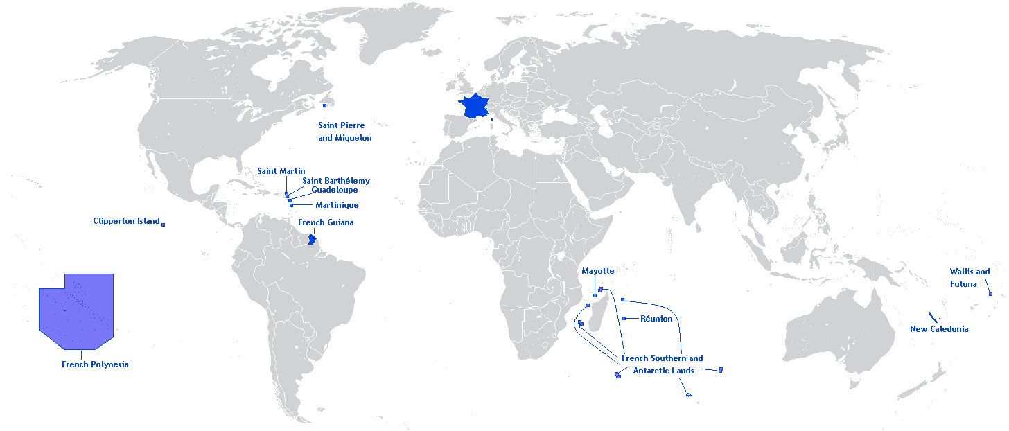
English: A map showing the Overseas departments and territories of France, excluding the territory of Adélie Land in Antarctica, where sovereignty is suspended |
| ਮਿਤੀ | |
| ਸਰੋਤ | ਆਪਣਾ ਕੰਮ |
| ਲਿਖਾਰੀ | Originally Hoshie |
| Other versions | Adapted from File:Outre-mer en.png |
English: This image is a cropped version of Image:Outre-mer en.png initally created by user Hoshie. Antarctica was cropped.
ਲਸੰਸ
Hoshie, the copyright holder of this work, hereby publishes it under the following license:

|
ਇਸ ਸਫ਼ੇ ਨੂੰ ਗਨੂ ਲਸੰਸ, ਵਰਜ਼ਨ 1.2 ਜਾਂ ਫਰੀ ਸਾਫਟਵੇਅਰ ਫਾਊਂਡੇਸ਼ਨ ਦੁਆਰਾ ਪ੍ਰਕਾਸ਼ਿਤ ਕੀਤੇ ਨਵੇਂ ਵਰਜ਼ਨ ਤਹਿਤ ਕਾਪੀ ਕਰਨ, ਵੰਡਣ ਜਾਂ/ਅਤੇ ਤਬਦੀਲੀ ਕਰਨ ਦੀ ਖੁੱਲ ਹੈ; ਬਿਨਾ ਕਿਸੇ ਸਥਿਰ ਫਰੰਟ-ਕਵਰ ਜਾਂ ਬੈਕ ਕਵਰ ਲਿਖਤਾਂ ਤੋਂ ਬਿਨਾਂ। ਇਸ ਲਸੰਸ ਦੀ ਇੱਕ ਕਾਪੀ ਇਸ ਗਨੂ ਫਰੀ ਲਸੰਸ ਭਾਗ ਵਿੱਚ ਮੌਜੂਦ ਹੈ। |
| ਇਸ ਫ਼ਾਈਲ ਦਾ ਲਸੰਸ ਕ੍ਰਿਏਟਿਵ ਕਾਮਨਜ਼ ਐਟ੍ਰੀਬਿਊਸ਼ਨ-ਸ਼ੇਅਰ ਅਲਾਈਕ 3.0 ਅਨਪੋਰਟੇਡ ਹੈ। | ||
| ਐਟਰੀਬਿਊਸ਼ਨ: Hoshie | ||
| ||
| This licensing tag was added to this file as part of the GFDL licensing update. |
ਫ਼ਾਈਲ ਦਾ ਅਤੀਤ
ਤਾਰੀਖ/ਸਮੇਂ ’ਤੇ ਕਲਿੱਕ ਕਰੋ ਤਾਂ ਉਸ ਸਮੇਂ ਦੀ ਫਾਈਲ ਪੇਸ਼ ਹੋ ਜਾਵੇਗੀ।
| ਮਿਤੀ/ਸਮਾਂ | ਨਮੂਨਾ | ਨਾਪ | ਵਰਤੋਂਕਾਰ | ਟਿੱਪਣੀ | |
|---|---|---|---|---|---|
| ਮੌਜੂਦਾ | 20:26, 27 ਮਾਰਚ 2018 | | 1,456 × 622 (49 KB) | Maphobbyist | Upload |
| 12:01, 27 ਮਈ 2012 |  | 1,456 × 622 (59 KB) | Hazhk | Changing color | |
| 20:47, 12 ਫ਼ਰਵਰੀ 2012 |  | 1,480 × 625 (68 KB) | Spesh531 | same as File:Outre-mer en.png, without Antarctica | |
| 00:35, 21 ਅਕਤੂਬਰ 2010 |  | 1,431 × 655 (54 KB) | Rosss | Better view of French Polynesia | |
| 21:23, 25 ਨਵੰਬਰ 2009 |  | 1,431 × 655 (30 KB) | The Illusional Ministry | removed borer from french polynesia | |
| 21:22, 25 ਨਵੰਬਰ 2009 |  | 1,431 × 655 (30 KB) | The Illusional Ministry | ||
| 03:31, 17 ਦਸੰਬਰ 2007 |  | 1,431 × 655 (35 KB) | Rosss | Wider margin | |
| 03:26, 17 ਦਸੰਬਰ 2007 |  | 1,431 × 639 (35 KB) | Rosss | This image is a cropped version of Image:Outre-mer en.png initally created by user Hoshie. Antartica was cropped. ==License== {{GFDL-user|Hoshie}} Category:World maps of Overseas France |
ਫ਼ਾਈਲ ਦੀ ਵਰਤੋਂ
ਇਹ ਫਾਈਲ ਹੇਠਾਂ ਦਿੱਤਾ ਸਫ਼ਾ ਵਰਤਦਾ ਹੈ:
ਫ਼ਾਈਲ ਦੀ ਵਿਆਪਕ ਵਰਤੋਂ
ਇਸ ਫ਼ਾਈਲ ਨੂੰ ਹੋਰ ਹੇਠ ਲਿਖੇ ਵਿਕੀ ਵਰਤਦੇ ਹਨ:
- an.wikipedia.org ਉੱਤੇ ਵਰਤੋਂ
- awa.wikipedia.org ਉੱਤੇ ਵਰਤੋਂ
- bn.wikibooks.org ਉੱਤੇ ਵਰਤੋਂ
- ckb.wikipedia.org ਉੱਤੇ ਵਰਤੋਂ
- da.wikipedia.org ਉੱਤੇ ਵਰਤੋਂ
- dv.wikipedia.org ਉੱਤੇ ਵਰਤੋਂ
- en.wikipedia.org ਉੱਤੇ ਵਰਤੋਂ
- Regions of France
- Outline of France
- Wikipedia:Graphics Lab/Map workshop/Archive/Dec 2009
- Wikipedia:Graphics Lab/Map workshop/Archive/Jun 2012
- User:SkulkingMEDIA
- User:Andreapr94/sandbox/Infobox/Country
- User:Jonperez91/sandbox/Infoboxes/Country
- User:Ane San José/sandbox/Infobox/Country
- User:P.aurrecoechea/Sandbox/Infobox/Country
- User:Trizia9/sandbox/Infobox/Country
- User:Ibonarzua/sandbox/Infobox/Country
- User:Mikel M/sandbox/Infobox/Country
- en.wikibooks.org ਉੱਤੇ ਵਰਤੋਂ
- es.wikipedia.org ਉੱਤੇ ਵਰਤੋਂ
- et.wikipedia.org ਉੱਤੇ ਵਰਤੋਂ
- eu.wikipedia.org ਉੱਤੇ ਵਰਤੋਂ
- fa.wikipedia.org ਉੱਤੇ ਵਰਤੋਂ
- fr.wikipedia.org ਉੱਤੇ ਵਰਤੋਂ
- hi.wikipedia.org ਉੱਤੇ ਵਰਤੋਂ
- hy.wikipedia.org ਉੱਤੇ ਵਰਤੋਂ
- id.wikipedia.org ਉੱਤੇ ਵਰਤੋਂ
- id.wikibooks.org ਉੱਤੇ ਵਰਤੋਂ
- ilo.wikipedia.org ਉੱਤੇ ਵਰਤੋਂ
- ja.wikipedia.org ਉੱਤੇ ਵਰਤੋਂ
- lv.wikipedia.org ਉੱਤੇ ਵਰਤੋਂ
- mai.wikipedia.org ਉੱਤੇ ਵਰਤੋਂ
- min.wikipedia.org ਉੱਤੇ ਵਰਤੋਂ
- ml.wikipedia.org ਉੱਤੇ ਵਰਤੋਂ
- mzn.wikipedia.org ਉੱਤੇ ਵਰਤੋਂ
- ne.wikipedia.org ਉੱਤੇ ਵਰਤੋਂ
- nl.wikipedia.org ਉੱਤੇ ਵਰਤੋਂ
- no.wikipedia.org ਉੱਤੇ ਵਰਤੋਂ
- pcd.wikipedia.org ਉੱਤੇ ਵਰਤੋਂ
- pdc.wikipedia.org ਉੱਤੇ ਵਰਤੋਂ
- pt.wikipedia.org ਉੱਤੇ ਵਰਤੋਂ
- sah.wikipedia.org ਉੱਤੇ ਵਰਤੋਂ
- sh.wikipedia.org ਉੱਤੇ ਵਰਤੋਂ
- sr.wikinews.org ਉੱਤੇ ਵਰਤੋਂ
ਇਸ ਫ਼ਾਈਲ ਦੀ ਹੋਰ ਵਿਆਪਕ ਵਰਤੋਂ ਵੇਖੋ।