
ਤਸਵੀਰ:Band-e-Amir National Park, Afghanistan.jpg

ਇਸ ਝਾਤ ਦਾ ਅਕਾਰ: 600 × 600 ਪਿਕਸਲ. ਹੋਰ ਰੈਜ਼ੋਲਿਊਸ਼ਨਜ਼: 240 × 240 ਪਿਕਸਲ | 480 × 480 ਪਿਕਸਲ | 768 × 768 ਪਿਕਸਲ | 1,024 × 1,024 ਪਿਕਸਲ | 2,048 × 2,048 ਪਿਕਸਲ | 3,500 × 3,500 ਪਿਕਸਲ.
ਅਸਲ ਫ਼ਾਈਲ (3,500 × 3,500 ਪਿਕਸਲ, ਫ਼ਾਈਲ ਅਕਾਰ: 4.14 MB, MIME ਕਿਸਮ: image/jpeg)
ਸਾਰ
| ਵੇਰਵਾ |
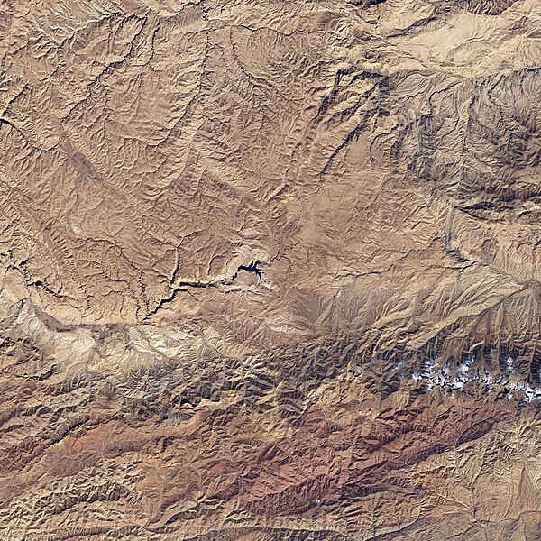
English: The starkness of the landscape highlights the ruggedness of the terrain around the lakes in this satellite image of Band-e-Amir National Park. Towering cliffs create sharp lines and shadows on the south (bottom) side of many of the lakes. The lakes range in color from faint turquoise to deep blue. |
| ਮਿਤੀ | |
| ਸਰੋਤ | NASA Earth Observatory |
| ਲਿਖਾਰੀ | NASA image created by Jesse Allen, using Landsat data provided by the United States Geological Survey. |
Landsat 7 - ETM+
ਲਸੰਸ
| This file is in the public domain in the United States because it was solely created by NASA. NASA copyright policy states that "NASA material is not protected by copyright unless noted". (See Template:PD-USGov, NASA copyright policy page or JPL Image Use Policy.) | ||
 |
Warnings:
|
ਫ਼ਾਈਲ ਦਾ ਅਤੀਤ
ਤਾਰੀਖ/ਸਮੇਂ ’ਤੇ ਕਲਿੱਕ ਕਰੋ ਤਾਂ ਉਸ ਸਮੇਂ ਦੀ ਫਾਈਲ ਪੇਸ਼ ਹੋ ਜਾਵੇਗੀ।
| ਮਿਤੀ/ਸਮਾਂ | ਨਮੂਨਾ | ਨਾਪ | ਵਰਤੋਂਕਾਰ | ਟਿੱਪਣੀ | |
|---|---|---|---|---|---|
| ਮੌਜੂਦਾ | 14:42, 26 ਅਪਰੈਲ 2009 | | 3,500 × 3,500 (4.14 MB) | Originalwana | {{Information |Description={{en|1=The starkness of the landscape highlights the ruggedness of the terrain around the lakes in this satellite image of Band-e-Amir National Park. Towering cliffs create sharp lines and shadows on the south side of many of th |
ਫ਼ਾਈਲ ਦੀ ਵਰਤੋਂ
ਇਹ ਫਾਈਲ ਹੇਠਾਂ ਦਿੱਤਾ ਸਫ਼ਾ ਵਰਤਦਾ ਹੈ:
ਫ਼ਾਈਲ ਦੀ ਵਿਆਪਕ ਵਰਤੋਂ
ਇਸ ਫ਼ਾਈਲ ਨੂੰ ਹੋਰ ਹੇਠ ਲਿਖੇ ਵਿਕੀ ਵਰਤਦੇ ਹਨ:
- az.wikipedia.org ਉੱਤੇ ਵਰਤੋਂ
- bg.wikipedia.org ਉੱਤੇ ਵਰਤੋਂ
- en.wikipedia.org ਉੱਤੇ ਵਰਤੋਂ
- fi.wikipedia.org ਉੱਤੇ ਵਰਤੋਂ
- id.wikipedia.org ਉੱਤੇ ਵਰਤੋਂ
- no.wikipedia.org ਉੱਤੇ ਵਰਤੋਂ
- ru.wikipedia.org ਉੱਤੇ ਵਰਤੋਂ
- sat.wikipedia.org ਉੱਤੇ ਵਰਤੋਂ
- sv.wikipedia.org ਉੱਤੇ ਵਰਤੋਂ
- uk.wikipedia.org ਉੱਤੇ ਵਰਤੋਂ