
ਤਸਵੀਰ:Europe-Jersey.svg

Size of this PNG preview of this SVG file: 713 × 600 ਪਿਕਸਲ. ਹੋਰ ਰੈਜ਼ੋਲਿਊਸ਼ਨਜ਼: 285 × 240 ਪਿਕਸਲ | 571 × 480 ਪਿਕਸਲ | 913 × 768 ਪਿਕਸਲ | 1,218 × 1,024 ਪਿਕਸਲ | 2,435 × 2,048 ਪਿਕਸਲ | 2,045 × 1,720 ਪਿਕਸਲ.
ਅਸਲ ਫ਼ਾਈਲ (SVG ਫ਼ਾਈਲ, ਆਮ ਤੌਰ ’ਤੇ 2,045 × 1,720 ਪਿਕਸਲ, ਫ਼ਾਈਲ ਦਾ ਅਕਾਰ: 7.73 MB)
ਸਾਰ
| ਵੇਰਵਾ |
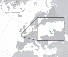
English: The Full Map of Jersey |
||
| ਮਿਤੀ | |||
| ਸਰੋਤ |
Own work based on: Europe-Northern Cyprus.svg and Europe-Serbia.svg |
||
| ਲਿਖਾਰੀ | Chipmunkdavis | ||
| Other versions |
Derivative works of this file: |
||
| SVG genesis |
|

ਲਸੰਸ
ਇਸ ਫ਼ਾਈਲ ਦਾ ਲਸੰਸ ਕ੍ਰਿਏਟਿਵ ਕਾਮਨਜ਼ ਐਟ੍ਰੀਬਿਊਸ਼ਨ-ਸ਼ੇਅਰ ਅਲਾਈਕ 3.0 ਅਨਪੋਰਟੇਡ ਹੈ।
- ਤੁਹਾਨੂੰ ਖੁੱਲ੍ਹ ਹੈ:
- ਸਾਂਝਾ ਕਰਨ ਦੀ – ਰਚਨਾ ਨੂੰ ਕਾਪੀ, ਵੰਡਣਾ ਅਤੇ ਭੇਜਣਾ
- ਮੁੜ-ਰਲ਼ਾਉਣ ਦੀ – ਰਚਨਾ ਨੂੰ ਢਾਲਣਾ
- ਥੱਲੇ ਲਿਖੀਆਂ ਸ਼ਰਤਾਂ ਹੇਠ:
- ਗੁਣਾਂ ਦੀ ਦੱਸ – ਉਚਿਤ ਕ੍ਰੈਡਿਟ ਦੇਵੋ, ਲਾਇਸੰਸ ਦਾ ਇੱਕ ਲਿੰਕ ਪ੍ਰਦਾਨ ਕਰੋ ਅਤੇ ਇਹ ਦਰਸਾਓ ਕਿ ਕੀ ਤਬਦੀਲੀਆਂ ਕੀਤੀਆਂ ਗਈਆਂ ਸਨ। ਤੁਸੀਂ ਇਹ ਕਿਸੇ ਵੀ ਵਾਜਬ ਤਰੀਕੇ ਨਾਲ ਕਰ ਸਕਦੇ ਹੋ, ਪਰ ਇਹ ਤਰੀਕਾ ਅਜਿਹਾ ਨਹੀਂ ਹੋਣਾ ਚਾਹੀਦਾ ਜੋ ਇਹ ਦਰਸਾਵੇ ਕਿ ਲਾਇਸੰਸਕਰਤਾ ਤੁਹਾਨੂੰ ਜਾਂ ਤੁਹਾਡੀ ਵਰਤੋਂ ਦਾ ਸਮਰਥਨ ਕਰਦਾ ਹੈ।
- ਸ਼ੇਅਰ ਅਲਾਈਕ – ਜੇਕਰ ਤੁਸੀਂ ਸਮੱਗਰੀ ਨੂੰ ਰੀਮਿਕਸ ਕਰਦੇ ਹੋ, ਬਦਲਦੇ ਹੋ ਜਾਂ ਬਣਾਉਂਦੇ ਹੋ, ਤਾਂ ਆਪਣੇ ਯੋਗਦਾਨ ਇੱਕੋ ਜਿਹੇ ਜਾਂ ਅਨੁਕੂਲ ਲਾਇਸੰਸ ਦੇ ਅਧੀਨ ਕਰੋ।
Original upload log
This image is a derivative work of the following images:
- Europe-Northern Cyprus.svg licensed with Cc-by-3.0
- 2011-02-20T17:16:12Z Chipmunkdavis 2045x1720 (2331880 Bytes) {{Information |Description={{en|1={{Europe-SVG-en|Northern Cyprus}}}} |Source=*[[:File:Europe-Serbia.svg|]] |Date=2011-02-20 17:14 (UTC) |Author=*[[:File:Europe-Serbia.svg|]]: {{click|image=TheEmirr-Logo.png|link=User:The Emi
- Jersey Map.svg licensed with PD-self
- 2009-04-02T01:46:41Z Ichwan Palongengi 626x433 (208689 Bytes) Remove the flaw...
- 2009-04-02T01:39:59Z Ichwan Palongengi 626x433 (207980 Bytes) {{Information |Description={{en|1=The Full Map of Jersey}} |Source=Own work by uploader |Author=[[User:Ichwan Palongengi|Ichwan Palongengi]] |Date=2009-03-01 |Permission= |other_versions= }} [[Category:Jersey]]
Uploaded with derivativeFX
ਫ਼ਾਈਲ ਦਾ ਅਤੀਤ
ਤਾਰੀਖ/ਸਮੇਂ ’ਤੇ ਕਲਿੱਕ ਕਰੋ ਤਾਂ ਉਸ ਸਮੇਂ ਦੀ ਫਾਈਲ ਪੇਸ਼ ਹੋ ਜਾਵੇਗੀ।
| ਮਿਤੀ/ਸਮਾਂ | ਨਮੂਨਾ | ਨਾਪ | ਵਰਤੋਂਕਾਰ | ਟਿੱਪਣੀ | |
|---|---|---|---|---|---|
| ਮੌਜੂਦਾ | 01:57, 8 ਨਵੰਬਰ 2017 | | 2,045 × 1,720 (7.73 MB) | Rob984 | Added circle like the original |
| 00:35, 8 ਨਵੰਬਰ 2017 |  | 2,045 × 1,720 (7.73 MB) | Rob984 | Modified to try to better locate the island both within the Channel and Europe (so multiple maps aren't needed) | |
| 07:49, 21 ਫ਼ਰਵਰੀ 2011 |  | 2,045 × 1,720 (2.28 MB) | Chipmunkdavis | {{Information |Description={{en|1={{Europe-SVG-en|Northern Cyprus}}}} {{en|1=The Full Map of Jersey}} |Source=*File:Europe-Northern_Cyprus.svg *File:Jersey_Map.svg |Date=2011-02-21 07:48 (UTC) |Author=*File:Europe-Northern_Cyprus.svg: *[ |
ਫ਼ਾਈਲ ਦੀ ਵਰਤੋਂ
ਇਹ ਫਾਈਲ ਹੇਠਾਂ ਦਿੱਤਾ ਸਫ਼ਾ ਵਰਤਦਾ ਹੈ:
ਫ਼ਾਈਲ ਦੀ ਵਿਆਪਕ ਵਰਤੋਂ
ਇਸ ਫ਼ਾਈਲ ਨੂੰ ਹੋਰ ਹੇਠ ਲਿਖੇ ਵਿਕੀ ਵਰਤਦੇ ਹਨ:
- af.wikipedia.org ਉੱਤੇ ਵਰਤੋਂ
- ang.wikipedia.org ਉੱਤੇ ਵਰਤੋਂ
- ar.wikipedia.org ਉੱਤੇ ਵਰਤੋਂ
- arz.wikipedia.org ਉੱਤੇ ਵਰਤੋਂ
- ast.wikipedia.org ਉੱਤੇ ਵਰਤੋਂ
- azb.wikipedia.org ਉੱਤੇ ਵਰਤੋਂ
- az.wikipedia.org ਉੱਤੇ ਵਰਤੋਂ
- be-tarask.wikipedia.org ਉੱਤੇ ਵਰਤੋਂ
- be.wikipedia.org ਉੱਤੇ ਵਰਤੋਂ
- bh.wikipedia.org ਉੱਤੇ ਵਰਤੋਂ
- bn.wikipedia.org ਉੱਤੇ ਵਰਤੋਂ
- ca.wikipedia.org ਉੱਤੇ ਵਰਤੋਂ
- cdo.wikipedia.org ਉੱਤੇ ਵਰਤੋਂ
- chr.wikipedia.org ਉੱਤੇ ਵਰਤੋਂ
- cs.wikipedia.org ਉੱਤੇ ਵਰਤੋਂ
- da.wikipedia.org ਉੱਤੇ ਵਰਤੋਂ
- diq.wikipedia.org ਉੱਤੇ ਵਰਤੋਂ
- en.wikipedia.org ਉੱਤੇ ਵਰਤੋਂ
- en.wikivoyage.org ਉੱਤੇ ਵਰਤੋਂ
- es.wikipedia.org ਉੱਤੇ ਵਰਤੋਂ
- fa.wikipedia.org ਉੱਤੇ ਵਰਤੋਂ
- fi.wikipedia.org ਉੱਤੇ ਵਰਤੋਂ
- fr.wikipedia.org ਉੱਤੇ ਵਰਤੋਂ
- ga.wikipedia.org ਉੱਤੇ ਵਰਤੋਂ
- gl.wikipedia.org ਉੱਤੇ ਵਰਤੋਂ
- hak.wikipedia.org ਉੱਤੇ ਵਰਤੋਂ
- ha.wikipedia.org ਉੱਤੇ ਵਰਤੋਂ
- he.wikipedia.org ਉੱਤੇ ਵਰਤੋਂ
- he.wikivoyage.org ਉੱਤੇ ਵਰਤੋਂ
- hr.wikipedia.org ਉੱਤੇ ਵਰਤੋਂ
- hy.wikipedia.org ਉੱਤੇ ਵਰਤੋਂ
- ia.wikipedia.org ਉੱਤੇ ਵਰਤੋਂ
- incubator.wikimedia.org ਉੱਤੇ ਵਰਤੋਂ
- is.wikipedia.org ਉੱਤੇ ਵਰਤੋਂ
- it.wikipedia.org ਉੱਤੇ ਵਰਤੋਂ
ਇਸ ਫ਼ਾਈਲ ਦੀ ਹੋਰ ਵਿਆਪਕ ਵਰਤੋਂ ਵੇਖੋ।