ਤਸਵੀਰ:Upper Siang district.png

ਪੰਨਾ ਸਮੱਗਰੀ ਹੋਰ ਭਾਸ਼ਾਵਾਂ ਵਿੱਚ ਸਮਰਥਿਤ ਨਹੀਂ ਹੈ।
ਵਿਕੀਪੀਡੀਆ, ਇੱਕ ਅਜ਼ਾਦ ਗਿਆਨਕੋਸ਼ ਤੋਂ

Upper_Siang_district.png(744 × 567 ਪਿਕਸਲ, ਫ਼ਾਈਲ ਅਕਾਰ: 295 KB, MIME ਕਿਸਮ: image/png)

ਇਹ ਫ਼ਾਈਲ Wikimedia Commons ਦੀ ਹੈ ਅਤੇ ਹੋਰ ਪਰਿਯੋਜਨਾਵਾਂ ਵਿੱਚ ਵੀ ਵਰਤੀ ਜਾ ਸਕਦੀ ਹੈ । ਇਸ ਫ਼ਾਈਲ ਦੇ ਵੇਰਵਾ ਸਫ਼ੇ ਵਿੱਚ ਮੌਜੂਦ ਵੇਰਵਾ ਹੇਠ ਦਿਸ ਰਿਹਾ ਹੈ।

ਸਾਰ

ਵੇਰਵਾ
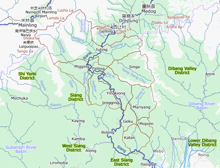
English: Upper Siang district with administrative circles and other labels
ਮਿਤੀ
ਸਰੋਤ overpass-turbo.eu, umap.openstreetmap.fr
ਲਿਖਾਰੀ
Description
This map was created from OpenStreetMap project data, collected by the community. This map may be incomplete, and may contain errors. Don't rely solely on it for navigation.
ਮਿਤੀ (see file history)
ਸਰੋਤ openstreetmap.org
Creator
OpenStreetMap contributors
ਇਜਾਜ਼ਤ
(ਇਸ ਫ਼ਾਈਲ ਦੀ ਮੁੜਵਰਤੋਂ ਕਰੋ)

OpenStreetMap data is available under the Open Database License (details). Map tiles are licensed under the Creative Commons Attribution-ShareAlike 2.0 license (CC-BY-SA 2.0).

This work contains information from OpenStreetMap, which is made available under the Open Database License (ODbL).

The ODbL does not require any particular license for maps produced from ODbL data. Prior to 1 August 2020, map tiles produced by the OpenStreetMap Foundation were licensed under the CC-BY-SA-2.0 license. Maps produced by other people may be subject to other licences.

w:en:Creative Commons
ਗੁਣਾਂ ਦੀ ਦੱਸ ਸ਼ੇਅਰ ਅਲਾਈਕ
This file is licensed under the Creative Commons Attribution-Share Alike 2.0 Generic license.
ਤੁਹਾਨੂੰ ਖੁੱਲ੍ਹ ਹੈ:
  • ਸਾਂਝਾ ਕਰਨ ਦੀ – ਰਚਨਾ ਨੂੰ ਕਾਪੀ, ਵੰਡਣਾ ਅਤੇ ਭੇਜਣਾ
  • ਮੁੜ-ਰਲ਼ਾਉਣ ਦੀ – ਰਚਨਾ ਨੂੰ ਢਾਲਣਾ
ਥੱਲੇ ਲਿਖੀਆਂ ਸ਼ਰਤਾਂ ਹੇਠ:
  • ਗੁਣਾਂ ਦੀ ਦੱਸ – ਉਚਿਤ ਕ੍ਰੈਡਿਟ ਦੇਵੋ, ਲਾਇਸੰਸ ਦਾ ਇੱਕ ਲਿੰਕ ਪ੍ਰਦਾਨ ਕਰੋ ਅਤੇ ਇਹ ਦਰਸਾਓ ਕਿ ਕੀ ਤਬਦੀਲੀਆਂ ਕੀਤੀਆਂ ਗਈਆਂ ਸਨ। ਤੁਸੀਂ ਇਹ ਕਿਸੇ ਵੀ ਵਾਜਬ ਤਰੀਕੇ ਨਾਲ ਕਰ ਸਕਦੇ ਹੋ, ਪਰ ਇਹ ਤਰੀਕਾ ਅਜਿਹਾ ਨਹੀਂ ਹੋਣਾ ਚਾਹੀਦਾ ਜੋ ਇਹ ਦਰਸਾਵੇ ਕਿ ਲਾਇਸੰਸਕਰਤਾ ਤੁਹਾਨੂੰ ਜਾਂ ਤੁਹਾਡੀ ਵਰਤੋਂ ਦਾ ਸਮਰਥਨ ਕਰਦਾ ਹੈ।
  • ਸ਼ੇਅਰ ਅਲਾਈਕ – ਜੇਕਰ ਤੁਸੀਂ ਸਮੱਗਰੀ ਨੂੰ ਰੀਮਿਕਸ ਕਰਦੇ ਹੋ, ਬਦਲਦੇ ਹੋ ਜਾਂ ਬਣਾਉਂਦੇ ਹੋ, ਤਾਂ ਆਪਣੇ ਯੋਗਦਾਨ ਇੱਕੋ ਜਿਹੇ ਜਾਂ ਅਨੁਕੂਲ ਲਾਇਸੰਸ ਦੇ ਅਧੀਨ ਕਰੋ।
Georeferencing Georeference the map in Wikimaps Warper If inappropriate please set warp_status = skip to hide.

ਲਸੰਸ

w:en:Creative Commons
ਗੁਣਾਂ ਦੀ ਦੱਸ ਸ਼ੇਅਰ ਅਲਾਈਕ
This file is licensed under the Creative Commons Attribution-Share Alike 4.0 International license.
ਤੁਹਾਨੂੰ ਖੁੱਲ੍ਹ ਹੈ:
  • ਸਾਂਝਾ ਕਰਨ ਦੀ – ਰਚਨਾ ਨੂੰ ਕਾਪੀ, ਵੰਡਣਾ ਅਤੇ ਭੇਜਣਾ
  • ਮੁੜ-ਰਲ਼ਾਉਣ ਦੀ – ਰਚਨਾ ਨੂੰ ਢਾਲਣਾ
ਥੱਲੇ ਲਿਖੀਆਂ ਸ਼ਰਤਾਂ ਹੇਠ:
  • ਗੁਣਾਂ ਦੀ ਦੱਸ – ਉਚਿਤ ਕ੍ਰੈਡਿਟ ਦੇਵੋ, ਲਾਇਸੰਸ ਦਾ ਇੱਕ ਲਿੰਕ ਪ੍ਰਦਾਨ ਕਰੋ ਅਤੇ ਇਹ ਦਰਸਾਓ ਕਿ ਕੀ ਤਬਦੀਲੀਆਂ ਕੀਤੀਆਂ ਗਈਆਂ ਸਨ। ਤੁਸੀਂ ਇਹ ਕਿਸੇ ਵੀ ਵਾਜਬ ਤਰੀਕੇ ਨਾਲ ਕਰ ਸਕਦੇ ਹੋ, ਪਰ ਇਹ ਤਰੀਕਾ ਅਜਿਹਾ ਨਹੀਂ ਹੋਣਾ ਚਾਹੀਦਾ ਜੋ ਇਹ ਦਰਸਾਵੇ ਕਿ ਲਾਇਸੰਸਕਰਤਾ ਤੁਹਾਨੂੰ ਜਾਂ ਤੁਹਾਡੀ ਵਰਤੋਂ ਦਾ ਸਮਰਥਨ ਕਰਦਾ ਹੈ।
  • ਸ਼ੇਅਰ ਅਲਾਈਕ – ਜੇਕਰ ਤੁਸੀਂ ਸਮੱਗਰੀ ਨੂੰ ਰੀਮਿਕਸ ਕਰਦੇ ਹੋ, ਬਦਲਦੇ ਹੋ ਜਾਂ ਬਣਾਉਂਦੇ ਹੋ, ਤਾਂ ਆਪਣੇ ਯੋਗਦਾਨ ਇੱਕੋ ਜਿਹੇ ਜਾਂ ਅਨੁਕੂਲ ਲਾਇਸੰਸ ਦੇ ਅਧੀਨ ਕਰੋ।

Captions

Add a one-line explanation of what this file represents
Upper Siang district

copyright status ਅੰਗਰੇਜ਼ੀ

copyrighted ਅੰਗਰੇਜ਼ੀ

28 ਜੁਲਾਈ 2021

ਫ਼ਾਈਲ ਦਾ ਅਤੀਤ

ਤਾਰੀਖ/ਸਮੇਂ ’ਤੇ ਕਲਿੱਕ ਕਰੋ ਤਾਂ ਉਸ ਸਮੇਂ ਦੀ ਫਾਈਲ ਪੇਸ਼ ਹੋ ਜਾਵੇਗੀ।

ਮਿਤੀ/ਸਮਾਂਨਮੂਨਾਨਾਪਵਰਤੋਂਕਾਰਟਿੱਪਣੀ
ਮੌਜੂਦਾ12:49, 28 ਜੁਲਾਈ 202112:49, 28 ਜੁਲਾਈ 2021 ਵੇਲੇ ਦੇ ਵਰਜਨ ਦਾ ਅੰਗੂਠਾਕਾਰ ਰੂਪ744 × 567 (295 KB)FacetsOfNonStickPansUploaded a work by {{openstreetmap}} from {{url|overpass-turbo.eu}}, {{url|umap.openstreetmap.fr}} with UploadWizard

ਇਹ ਫਾਈਲ ਹੇਠਾਂ ਦਿੱਤੇ 2 ਸਫ਼ੇ ਵਰਤਦੇ ਹਨ:

ਫ਼ਾਈਲ ਦੀ ਵਿਆਪਕ ਵਰਤੋਂ

ਇਸ ਫ਼ਾਈਲ ਨੂੰ ਹੋਰ ਹੇਠ ਲਿਖੇ ਵਿਕੀ ਵਰਤਦੇ ਹਨ: