
ਤਸਵੀਰ:Biafra independent state map-en.svg

Size of this PNG preview of this SVG file: 776 × 600 ਪਿਕਸਲ. ਹੋਰ ਰੈਜ਼ੋਲਿਊਸ਼ਨਜ਼: 311 × 240 ਪਿਕਸਲ | 621 × 480 ਪਿਕਸਲ | 994 × 768 ਪਿਕਸਲ | 1,280 × 989 ਪਿਕਸਲ | 2,560 × 1,978 ਪਿਕਸਲ | 1,100 × 850 ਪਿਕਸਲ.
ਅਸਲ ਫ਼ਾਈਲ (SVG ਫ਼ਾਈਲ, ਆਮ ਤੌਰ ’ਤੇ 1,100 × 850 ਪਿਕਸਲ, ਫ਼ਾਈਲ ਦਾ ਅਕਾਰ: 472 KB)

|
This SVG file contains embedded text that can be translated into your language, using any capable SVG editor, text editor or the SVG Translate tool. For more information see: About translating SVG files. |
ਸਾਰ
| ਵੇਰਵਾ |
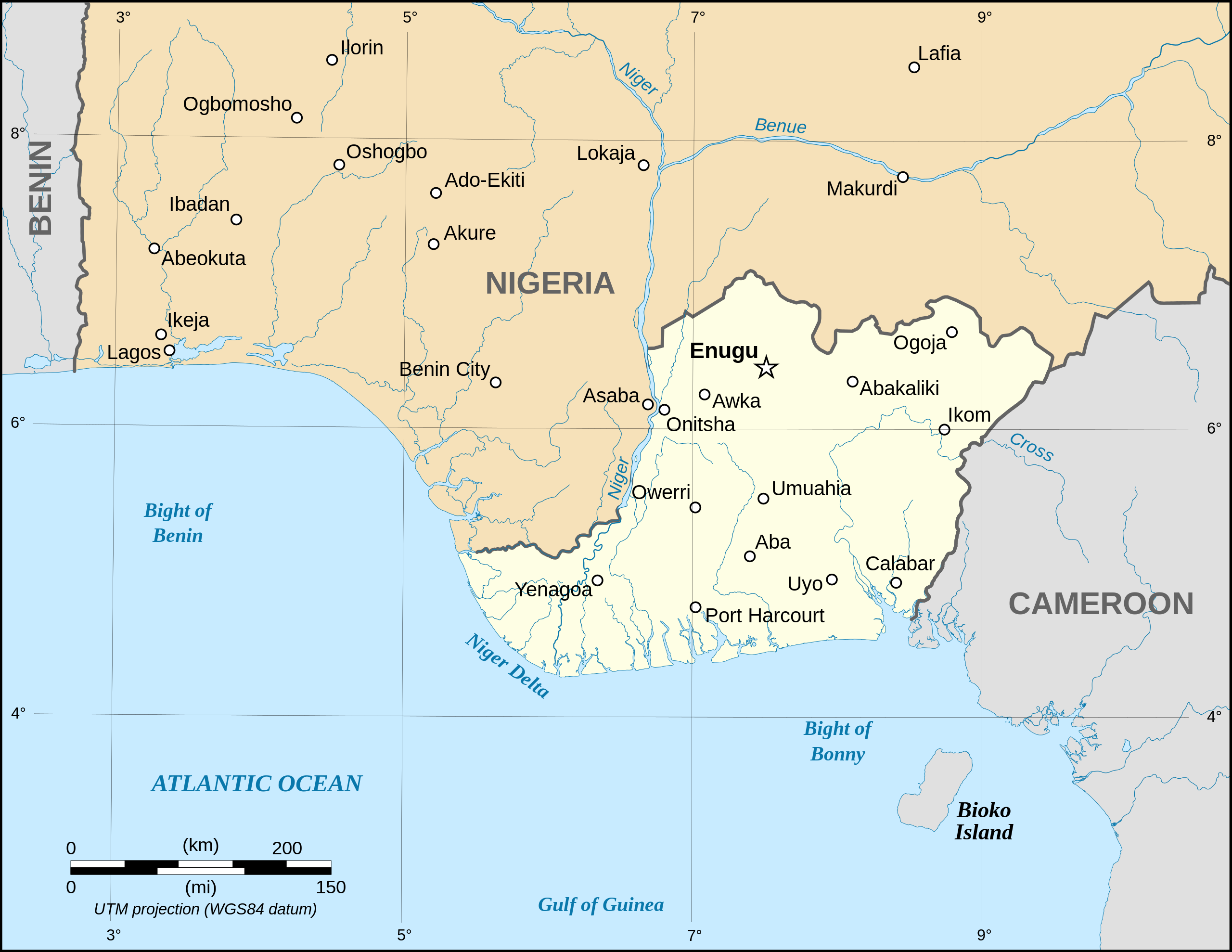
Català: Mapa de la república de Biafra en el maig 1967. English: Map of the secessionist state of the Republic of Biafra (1967 – 1970) as in May 1967. Note: The western boundary may not be accurate due to the low precision of the reference maps used which are also contradictory. Français : Carte en anglais de l'État sécessionniste de la République du Biafra (1967 – 1970) telle qu'en mai 1967. Note : La frontière Ouest peut ne pas être précise en raison de l'imprécision des cartes de référence qui sont aussi contradictoires. UTM projection ; WGS 84 datum |
||
| ਮਿਤੀ | September 2008 (new version) | ||
| ਸਰੋਤ |
Own work
|
||
| ਲਿਖਾਰੀ | Eric Gaba (Sting - fr:Sting) | ||
| ਇਜਾਜ਼ਤ (ਇਸ ਫ਼ਾਈਲ ਦੀ ਮੁੜਵਰਤੋਂ ਕਰੋ) |
|
||
| Other versions |
[]
|


|
|
This SVG file contains embedded text that can be translated into your language, using any capable SVG editor, text editor or the SVG Translate tool. For more information see: About translating SVG files. |
ਲਸੰਸ
I, the copyright holder of this work, hereby publish it under the following licenses:

|
ਇਸ ਸਫ਼ੇ ਨੂੰ ਗਨੂ ਲਸੰਸ, ਵਰਜ਼ਨ 1.2 ਜਾਂ ਫਰੀ ਸਾਫਟਵੇਅਰ ਫਾਊਂਡੇਸ਼ਨ ਦੁਆਰਾ ਪ੍ਰਕਾਸ਼ਿਤ ਕੀਤੇ ਨਵੇਂ ਵਰਜ਼ਨ ਤਹਿਤ ਕਾਪੀ ਕਰਨ, ਵੰਡਣ ਜਾਂ/ਅਤੇ ਤਬਦੀਲੀ ਕਰਨ ਦੀ ਖੁੱਲ ਹੈ; ਬਿਨਾ ਕਿਸੇ ਸਥਿਰ ਫਰੰਟ-ਕਵਰ ਜਾਂ ਬੈਕ ਕਵਰ ਲਿਖਤਾਂ ਤੋਂ ਬਿਨਾਂ। ਇਸ ਲਸੰਸ ਦੀ ਇੱਕ ਕਾਪੀ ਇਸ ਗਨੂ ਫਰੀ ਲਸੰਸ ਭਾਗ ਵਿੱਚ ਮੌਜੂਦ ਹੈ। |
| ਇਸ ਫ਼ਾਈਲ ਦਾ ਲਸੰਸ ਕ੍ਰਿਏਟਿਵ ਕਾਮਨਜ਼ ਐਟ੍ਰੀਬਿਊਸ਼ਨ-ਸ਼ੇਅਰ ਅਲਾਈਕ 3.0 ਅਨਪੋਰਟੇਡ ਹੈ। | ||
| ||
| This licensing tag was added to this file as part of the GFDL licensing update. |
This file is licensed under the Creative Commons Attribution-Share Alike 2.5 Generic, 2.0 Generic and 1.0 Generic license.
- ਤੁਹਾਨੂੰ ਖੁੱਲ੍ਹ ਹੈ:
- ਸਾਂਝਾ ਕਰਨ ਦੀ – ਰਚਨਾ ਨੂੰ ਕਾਪੀ, ਵੰਡਣਾ ਅਤੇ ਭੇਜਣਾ
- ਮੁੜ-ਰਲ਼ਾਉਣ ਦੀ – ਰਚਨਾ ਨੂੰ ਢਾਲਣਾ
- ਥੱਲੇ ਲਿਖੀਆਂ ਸ਼ਰਤਾਂ ਹੇਠ:
- ਗੁਣਾਂ ਦੀ ਦੱਸ – ਉਚਿਤ ਕ੍ਰੈਡਿਟ ਦੇਵੋ, ਲਾਇਸੰਸ ਦਾ ਇੱਕ ਲਿੰਕ ਪ੍ਰਦਾਨ ਕਰੋ ਅਤੇ ਇਹ ਦਰਸਾਓ ਕਿ ਕੀ ਤਬਦੀਲੀਆਂ ਕੀਤੀਆਂ ਗਈਆਂ ਸਨ। ਤੁਸੀਂ ਇਹ ਕਿਸੇ ਵੀ ਵਾਜਬ ਤਰੀਕੇ ਨਾਲ ਕਰ ਸਕਦੇ ਹੋ, ਪਰ ਇਹ ਤਰੀਕਾ ਅਜਿਹਾ ਨਹੀਂ ਹੋਣਾ ਚਾਹੀਦਾ ਜੋ ਇਹ ਦਰਸਾਵੇ ਕਿ ਲਾਇਸੰਸਕਰਤਾ ਤੁਹਾਨੂੰ ਜਾਂ ਤੁਹਾਡੀ ਵਰਤੋਂ ਦਾ ਸਮਰਥਨ ਕਰਦਾ ਹੈ।
- ਸ਼ੇਅਰ ਅਲਾਈਕ – ਜੇਕਰ ਤੁਸੀਂ ਸਮੱਗਰੀ ਨੂੰ ਰੀਮਿਕਸ ਕਰਦੇ ਹੋ, ਬਦਲਦੇ ਹੋ ਜਾਂ ਬਣਾਉਂਦੇ ਹੋ, ਤਾਂ ਆਪਣੇ ਯੋਗਦਾਨ ਇੱਕੋ ਜਿਹੇ ਜਾਂ ਅਨੁਕੂਲ ਲਾਇਸੰਸ ਦੇ ਅਧੀਨ ਕਰੋ।
ਤੁਸੀਂ ਆਪਣੀ ਮਰਜ਼ੀ ਦਾ ਲਸੰਸ ਚੁਣ ਸਕਦੇ ਹੋ।
ਫ਼ਾਈਲ ਦਾ ਅਤੀਤ
ਤਾਰੀਖ/ਸਮੇਂ ’ਤੇ ਕਲਿੱਕ ਕਰੋ ਤਾਂ ਉਸ ਸਮੇਂ ਦੀ ਫਾਈਲ ਪੇਸ਼ ਹੋ ਜਾਵੇਗੀ।
| ਮਿਤੀ/ਸਮਾਂ | ਨਮੂਨਾ | ਨਾਪ | ਵਰਤੋਂਕਾਰ | ਟਿੱਪਣੀ | |
|---|---|---|---|---|---|
| ਮੌਜੂਦਾ | 19:21, 15 ਸਤੰਬਰ 2023 | | 1,100 × 850 (472 KB) | Glrx | 256 kB workaround // Editing SVG source code using c:User:Rillke/SVGedit.js |
| 10:59, 15 ਸਤੰਬਰ 2023 |  | 1,100 × 850 (472 KB) | KajenCAT | File uploaded using svgtranslate tool (https://svgtranslate.toolforge.org/). Added translation for ca. | |
| 04:51, 3 ਸਤੰਬਰ 2008 |  | 1,100 × 850 (455 KB) | Sting | New version using the NGDC GSHHS and WDBII data ; new standard colors | |
| 17:54, 12 ਦਸੰਬਰ 2006 |  | 1,100 × 850 (163 KB) | Sting | {{Information| |Description=Map of the secessionist state of the Republic of Biafra (1967 – 1970) |Source=Own work<br/>Background reference map : Microsoft Encarta atlas (1999 edition)<br/>Biafra independent state borders reference maps : [http://www.bi |
ਫ਼ਾਈਲ ਦੀ ਵਰਤੋਂ
ਇਹ ਫਾਈਲ ਹੇਠਾਂ ਦਿੱਤਾ ਸਫ਼ਾ ਵਰਤਦਾ ਹੈ:
ਫ਼ਾਈਲ ਦੀ ਵਿਆਪਕ ਵਰਤੋਂ
ਇਸ ਫ਼ਾਈਲ ਨੂੰ ਹੋਰ ਹੇਠ ਲਿਖੇ ਵਿਕੀ ਵਰਤਦੇ ਹਨ:
- af.wikipedia.org ਉੱਤੇ ਵਰਤੋਂ
- ar.wikipedia.org ਉੱਤੇ ਵਰਤੋਂ
- ast.wikipedia.org ਉੱਤੇ ਵਰਤੋਂ
- azb.wikipedia.org ਉੱਤੇ ਵਰਤੋਂ
- be.wikipedia.org ਉੱਤੇ ਵਰਤੋਂ
- bn.wikipedia.org ਉੱਤੇ ਵਰਤੋਂ
- br.wikipedia.org ਉੱਤੇ ਵਰਤੋਂ
- ca.wikipedia.org ਉੱਤੇ ਵਰਤੋਂ
- cs.wikipedia.org ਉੱਤੇ ਵਰਤੋਂ
- da.wikipedia.org ਉੱਤੇ ਵਰਤੋਂ
- el.wikipedia.org ਉੱਤੇ ਵਰਤੋਂ
- en.wikipedia.org ਉੱਤੇ ਵਰਤੋਂ
- eo.wikipedia.org ਉੱਤੇ ਵਰਤੋਂ
- es.wikipedia.org ਉੱਤੇ ਵਰਤੋਂ
- et.wikipedia.org ਉੱਤੇ ਵਰਤੋਂ
- eu.wikipedia.org ਉੱਤੇ ਵਰਤੋਂ
- fa.wikipedia.org ਉੱਤੇ ਵਰਤੋਂ
- gl.wikipedia.org ਉੱਤੇ ਵਰਤੋਂ
- ha.wikipedia.org ਉੱਤੇ ਵਰਤੋਂ
- he.wikipedia.org ਉੱਤੇ ਵਰਤੋਂ
- hu.wikipedia.org ਉੱਤੇ ਵਰਤੋਂ
- hy.wikipedia.org ਉੱਤੇ ਵਰਤੋਂ
- id.wikipedia.org ਉੱਤੇ ਵਰਤੋਂ
- ig.wikipedia.org ਉੱਤੇ ਵਰਤੋਂ
- io.wikipedia.org ਉੱਤੇ ਵਰਤੋਂ
- is.wikipedia.org ਉੱਤੇ ਵਰਤੋਂ
- ja.wikipedia.org ਉੱਤੇ ਵਰਤੋਂ
ਇਸ ਫ਼ਾਈਲ ਦੀ ਹੋਰ ਵਿਆਪਕ ਵਰਤੋਂ ਵੇਖੋ।