ਨੈਸ਼ਨਲ ਹਾਈਵੇ 2 (ਭਾਰਤ)
ਦਿੱਖ
| National Highway 2 | ||||
|---|---|---|---|---|
Map of the National Highway in red | ||||
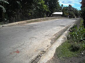
 Namdang Stone Bridge built in 1703 carries NH-2 | ||||
| Route information | ||||
| Part of Lua error in package.lua at line 80: module 'Module:Road data/extra' not found.Lua error in package.lua at line 80: module 'Module:Road data/extra' not found. | ||||
| Maintained by NHAI | ||||
| Length | 1,325.6 km (823.7 mi) | |||
| Major junctions | ||||
| North end | Lua error in package.lua at line 80: module 'Module:Road data/extra' not found. in Dibrugarh | |||
| ||||
| South end | Tuipang | |||
| Location | ||||
| Country | India | |||
| States | Assam, Nagaland, Manipur, Mizoram | |||
| Primary destinations | Sivasagar, Jhanji, Amguri, Mokokchung, Wokha, Kohima, Imphal, Churachandpur, Sasaram, Seling, Serchhip, Lawngtlai | |||
| Highway system | ||||
| ||||
ਰਾਸ਼ਟਰੀ ਰਾਜਮਾਰਗ 2 ਭਾਰਤ ਦਾ ਇੱਕ ਰਾਸ਼ਟਰੀ ਰਾਜਮਾਰਗ ਹੈ ਜੋ ਅਸਾਮ ਦੇ ਡਿਬਰੂਗੜ੍ਹ ਤੋਂ ਮਿਜ਼ੋਰਮ ਦੇ ਤੁਈਪਾਂਗ ਤੱਕ ਜਾਂਦਾ ਹੈ।[1] ਇਹ ਰਾਸ਼ਟਰੀ ਰਾਜਮਾਰਗ ਭਾਰਤੀ ਰਾਜਾਂ ਅਸਾਮ, ਨਾਗਾਲੈਂਡ, ਮਨੀਪੁਰ ਅਤੇ ਮਿਜ਼ੋਰਮ ਵਿੱਚੋਂ ਲੰਘਦਾ ਹੈ। ਇਹ ਰਾਸ਼ਟਰੀ ਰਾਜਮਾਰਗ 1,325.6 ਕਿਮੀ (823.7 ਮੀਲ) ਲੰਬਾ ਹੈ।[2] ਰਾਸ਼ਟਰੀ ਰਾਜਮਾਰਗਾਂ ਦੇ ਮੁੜ ਨੰਬਰ ਦੇਣ ਤੋਂ ਪਹਿਲਾਂ, NH-2 ਨੂੰ ਪੁਰਾਣੇ ਰਾਸ਼ਟਰੀ ਰਾਜਮਾਰਗ 37, 61, 39, 150 ਅਤੇ 54 ਦੇ ਤੌਰ 'ਤੇ ਵੱਖ-ਵੱਖ ਤੌਰ 'ਤੇ ਨੰਬਰ ਦਿੱਤਾ ਗਿਆ ਸੀ।[3]
ਹਵਾਲੇ
[ਸੋਧੋ]- ↑ "Rationalization of Numbering Systems of National Highways" (PDF). Govt of India. 28 April 2010. Retrieved 21 Aug 2011.
- ↑ "State-wise length of National Highways (NH) in India". Ministry of Road Transport and Highways. Retrieved 4 May 2019.
- ↑ "New Numbering of National Highways notification - Government of India" (PDF). The Gazette of India. Retrieved 4 May 2019.


