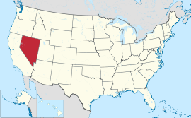
ਨਵਾਡਾ
| ਨਵਾਡਾ ਦਾ ਰਾਜ State of Nevada | |||||
| |||||
| ਉੱਪ-ਨਾਂ: ਚਾਂਦੀ ਰਾਜ (ਅਧਿਕਾਰਕ); ਸੇਜਬਰੱਸ਼ ਰਾਜ; ਜੰਗ ਤੋਂ ਜੰਮਿਆ ਰਾਜ | |||||
| ਮਾਟੋ: All For Our Country ਸਾਰੇ ਸਾਡੇ ਦੇਸ਼ ਲਈ | |||||
 | |||||
| ਦਫ਼ਤਰੀ ਭਾਸ਼ਾਵਾਂ | ਕਨੂੰਨੀ: ਕੋਈ ਨਹੀਂ ਯਥਾਰਥ: ਅੰਗਰੇਜ਼ੀ | ||||
| ਵਸਨੀਕੀ ਨਾਂ | ਨਵਾਡਾਈ | ||||
| ਰਾਜਧਾਨੀ | ਕਾਰਸਨ ਸ਼ਹਿਰ | ||||
| ਸਭ ਤੋਂ ਵੱਡਾ ਸ਼ਹਿਰ | ਲਾਸ ਵੇਗਸ | ||||
| ਸਭ ਤੋਂ ਵੱਡਾ ਮਹਾਂਨਗਰੀ ਇਲਾਕਾ | ਲਾਸ ਵੇਗਸ ਮਹਾਂਨਗਰੀ ਇਲਾਕਾ | ||||
| ਰਕਬਾ | ਸੰਯੁਕਤ ਰਾਜ ਵਿੱਚ 7ਵਾਂ ਦਰਜਾ | ||||
| - ਕੁੱਲ | 110,622 sq mi (286,367 ਕਿ.ਮੀ.੨) | ||||
| - ਚੁੜਾਈ | 322 ਮੀਲ (519 ਕਿ.ਮੀ.) | ||||
| - ਲੰਬਾਈ | 492 ਮੀਲ (787 ਕਿ.ਮੀ.) | ||||
| - % ਪਾਣੀ | |||||
| - ਵਿਥਕਾਰ | 35° N to 42° N | ||||
| - ਲੰਬਕਾਰ | 114° 2′ W to 120° W | ||||
| ਅਬਾਦੀ | ਸੰਯੁਕਤ ਰਾਜ ਵਿੱਚ 35ਵਾਂ ਦਰਜਾ | ||||
| - ਕੁੱਲ | 2,758,931 (2012 ਦਾ ਅੰਦਾਜ਼ਾ)[1] | ||||
| - ਘਣਤਾ | 24.8/sq mi (9.57/km2) ਸੰਯੁਕਤ ਰਾਜ ਵਿੱਚ 42ਵਾਂ ਦਰਜਾ | ||||
| - ਮੱਧਵਰਤੀ ਘਰੇਲੂ ਆਮਦਨ | $56,361 (15ਵਾਂ) | ||||
| ਉਚਾਈ | |||||
| - ਸਭ ਤੋਂ ਉੱਚੀ ਥਾਂ | ਸਰਹੱਦ ਚੋਟੀ[2][3][4][5] 13,147 ft (4007.1 m) | ||||
| - ਔਸਤ | 5,500 ft (1680 m) | ||||
| - ਸਭ ਤੋਂ ਨੀਵੀਂ ਥਾਂ | ਕੈਲੀਫ਼ੋਰਨੀਆ ਸਰਹੱਦ ਉੱਤੇ ਕੋਲੋਰਾਡੋ ਦਰਿਆ[3][4] 481 ft (147 m) | ||||
| ਸੰਘ ਵਿੱਚ ਪ੍ਰਵੇਸ਼ | 31 ਅਕਤੂਬਰ 1864 (36ਵਾਂ) | ||||
| ਰਾਜਪਾਲ | ਬ੍ਰਾਇਅਨ ਸੈਂਡੋਵਲ (ਗ) | ||||
| ਲੈਫਟੀਨੈਂਟ ਰਾਜਪਾਲ | ਬ੍ਰਾਇਅਨ ਕ੍ਰੋਲਿਕੀ (ਗ) | ||||
| ਵਿਧਾਨ ਸਭਾ | ਨਵਾਡਾ ਵਿਧਾਨ ਸਭਾ | ||||
| - ਉਤਲਾ ਸਦਨ | ਸੈਨੇਟ | ||||
| - ਹੇਠਲਾ ਸਦਨ | ਸਭਾ | ||||
| ਸੰਯੁਕਤ ਰਾਜ ਸੈਨੇਟਰ | ਹੈਰੀ ਰਾਈਡ (ਲੋ) ਡੀਨ ਹੈਲਰ (ਗ) | ||||
| ਸੰਯੁਕਤ ਰਾਜ ਸਦਨ ਵਫ਼ਦ | 1: ਡੀਨਾ ਟਾਈਟਸ (ਲੋ) 2: ਮਾਰਕ ਅਮੋਡੀ (ਗ) 3: ਜੋ ਹੈੱਕ (ਗ) 4: ਸਟੀਵਨ ਹੋਰਸਫ਼ੋਰਡ (ਲੋ) (list) | ||||
| ਸਮਾਂ ਜੋਨਾਂ | |||||
| - ਜ਼ਿਆਦਾਤਰ ਰਾਜ | ਪ੍ਰਸ਼ਾਂਤ: UTC -8/-7 | ||||
| - ਵੈਸਟ ਵੈਂਡੋਵਰ | ਪਹਾੜੀ: UTC -7/-6 | ||||
| ਛੋਟੇ ਰੂਪ | NV Nev. US-NV | ||||
| ਵੈੱਬਸਾਈਟ | www | ||||
ਨਵਾਡਾ (/nəˈvædə/ (![]() ਸੁਣੋ)) ਸੰਯੁਕਤ ਰਾਜ ਦੇ ਪੱਛਮੀ, ਪਹਾੜ ਪੱਛਮੀ ਅਤੇ ਦੱਖਣ-ਪੱਛਮੀ ਖੇਤਰਾਂ ਵਿੱਚ ਸਥਿਤ ਇੱਕ ਰਾਜ ਹੈ। ਇਹ ਪੰਜਾਹ ਸੰਯੁਕਤ ਰਾਜਾਂ ਵਿੱਚੋਂ 7ਵਾਂ ਸਭ ਤੋਂ ਵੱਡਾ, 35ਵਾਂ ਸਭ ਤੋਂ ਵੱਧ ਅਬਾਦੀ ਵਾਲਾ ਅਤੇ 9ਵਾਂ ਸਭ ਤੋਂ ਘੱਟ ਅਬਾਦੀ ਘਣਤਾ ਵਾਲਾ ਰਾਜ ਹੈ। ਇਸ ਰਾਜ ਦੀ ਅਬਾਦੀ ਦਾ ਦੋ-ਤਿਹਾਈ ਤੋਂ ਵੱਧ ਹਿੱਸਾ ਇੱਕੋ ਕਾਊਂਟੀ, ਕਲਾਰਕ ਕਾਊਂਟੀ, ਵਿੱਚ ਰਹਿੰਦਾ ਹੈ ਜਿਸ ਵਿੱਚ ਲਾਸ ਵੇਗਸ-ਪੈਰਾਡਾਈਸ ਮਹਾਂਨਗਰੀ ਇਲਾਕਾ ਸ਼ਾਮਲ ਹੈ,[6] ਜਿਸ ਵਿੱਚ ਰਾਜ ਦੇ ਤਿੰਨ ਸਭ ਤੋਂ ਵੱਡੇ ਸੰਮਿਲਤ ਸ਼ਹਿਰ ਸਥਿਤ ਹਨ।[7] ਇਸ ਦੀ ਰਾਜਧਾਨੀ ਕਾਰਸਨ ਸ਼ਹਿਰ ਹੈ।
ਸੁਣੋ)) ਸੰਯੁਕਤ ਰਾਜ ਦੇ ਪੱਛਮੀ, ਪਹਾੜ ਪੱਛਮੀ ਅਤੇ ਦੱਖਣ-ਪੱਛਮੀ ਖੇਤਰਾਂ ਵਿੱਚ ਸਥਿਤ ਇੱਕ ਰਾਜ ਹੈ। ਇਹ ਪੰਜਾਹ ਸੰਯੁਕਤ ਰਾਜਾਂ ਵਿੱਚੋਂ 7ਵਾਂ ਸਭ ਤੋਂ ਵੱਡਾ, 35ਵਾਂ ਸਭ ਤੋਂ ਵੱਧ ਅਬਾਦੀ ਵਾਲਾ ਅਤੇ 9ਵਾਂ ਸਭ ਤੋਂ ਘੱਟ ਅਬਾਦੀ ਘਣਤਾ ਵਾਲਾ ਰਾਜ ਹੈ। ਇਸ ਰਾਜ ਦੀ ਅਬਾਦੀ ਦਾ ਦੋ-ਤਿਹਾਈ ਤੋਂ ਵੱਧ ਹਿੱਸਾ ਇੱਕੋ ਕਾਊਂਟੀ, ਕਲਾਰਕ ਕਾਊਂਟੀ, ਵਿੱਚ ਰਹਿੰਦਾ ਹੈ ਜਿਸ ਵਿੱਚ ਲਾਸ ਵੇਗਸ-ਪੈਰਾਡਾਈਸ ਮਹਾਂਨਗਰੀ ਇਲਾਕਾ ਸ਼ਾਮਲ ਹੈ,[6] ਜਿਸ ਵਿੱਚ ਰਾਜ ਦੇ ਤਿੰਨ ਸਭ ਤੋਂ ਵੱਡੇ ਸੰਮਿਲਤ ਸ਼ਹਿਰ ਸਥਿਤ ਹਨ।[7] ਇਸ ਦੀ ਰਾਜਧਾਨੀ ਕਾਰਸਨ ਸ਼ਹਿਰ ਹੈ।
ਹਵਾਲੇ[ਸੋਧੋ]
- ↑ "Annual Estimates of the Population for the United States, Regions, States, and Puerto Rico: April 1, 2010 to July 1, 2012" (CSV). 2012 Population Estimates. United States Census Bureau, Population Division. December 2012. Retrieved December 24, 2012.
- ↑ "Boundary". NGS data sheet. U.S. National Geodetic Survey. http://www.ngs.noaa.gov/cgi-bin/ds_mark.prl?PidBox=HR2576. Retrieved October 20, 2011.
- ↑ 3.0 3.1 "Elevations and Distances in the United States". United States Geological Survey. 2001. Archived from the original on ਅਕਤੂਬਰ 15, 2011. Retrieved October 24, 2011.
{{cite web}}: Unknown parameter|dead-url=ignored (|url-status=suggested) (help) - ↑ 4.0 4.1 Elevation adjusted to North American Vertical Datum of 1988.
- ↑ The distinction of highest point in Nevada goes to the summit of Boundary Peak, so named because it is very near the Nevada-California border, at the northern terminus of the White Mountains. However, Boundary Peak can be considered a subsidiary summit of Montgomery Peak, whose summit is in California, since the topographic prominence of Boundary Peak is only 253 feet (77 m), which falls under the often used 300-foot (91 m) cutoff for an independent peak. Also, Boundary Peak is less than 1 mile (1.6 km) away from its higher neighbor. Hence Boundary Peak can be described as not being wholly within Nevada. By contrast, the prominence of Wheeler Peak, 13,063 feet (3,982 m), is quite large and in fact it is the twelfth largest in the contiguous United States. Wheeler Peak is the highest point in a radius of more than 200 square miles (520 km2) and is entirely within the state of Nevada.
- ↑ "Table 1. Annual Estimates of the Population of Metropolitan and Micropolitan Statistical Areas: April 1, 2010 to July 1, 2011 (CBSA-EST2011-01)" (CSV). 2011 Population Estimates. United States Census Bureau, Population Division. December 24, 2012. Retrieved December 24, 2012.
- ↑ http://www.census.gov/popest/data/cities/totals/2011/tables/SUB-EST2011-03-32.csv


