
ਕਰਨਾਟਕ
(ਕਰਨਾਟਕਾ ਤੋਂ ਮੋੜਿਆ ਗਿਆ)
ਕਰਨਾਟਕ
ಕರ್ನಾಟಕ | |||||
|---|---|---|---|---|---|
ਰਾਜ | |||||
| |||||
 ਕਰਨਾਟਕ ਦੀ ਭਾਰਤ ਵਿੱਚ ਸਥਿਤੀ | |||||
 ਕਰਨਾਟਕ ਦਾ ਨਕਸ਼ਾ | |||||
| ਦੇਸ਼ | |||||
| ਖੇਤਰ | ਦੱਖਣੀ ਭਾਰਤ | ||||
| Established | 1 ਨਵੰਬਰ 1956 | ||||
| ਰਾਜਧਾਨੀ | ਬੰਗਲੁਰੂ | ||||
| ਸਭ ਤੋਂ ਵੱਡਾ ਸ਼ਹਿਰ | ਬੰਗਲੁਰੂ | ||||
| ਜ਼ਿਲ੍ਹੇ | 30 | ||||
| ਸਰਕਾਰ | |||||
| • ਬਾਡੀ | Government of Karnataka | ||||
| • Governor | Vajubhai Vala | ||||
| • ChiefMinister | Siddaramaiah (Indian National Congress) | ||||
| • Legislature | Bicameral (224 + 75 seats) | ||||
| • High Court | Karnataka High Court | ||||
| ਖੇਤਰ | |||||
| • ਕੁੱਲ | 1,91,791 km2 (74,051 sq mi) | ||||
| • ਰੈਂਕ | 7th | ||||
| ਆਬਾਦੀ (2011)[2] | |||||
| • ਕੁੱਲ | 6,11,30,704 | ||||
| • ਰੈਂਕ | 8th | ||||
| • ਘਣਤਾ | 320/km2 (830/sq mi) | ||||
| ਸਮਾਂ ਖੇਤਰ | ਯੂਟੀਸੀ+05:30 (IST) | ||||
| ISO 3166 ਕੋਡ | IN-KA | ||||
| ਦਫ਼ਤਰੀ ਭਾਸ਼ਾ | ਕੰਨੜ[3][4] | ||||
| Literacy | 75.60% (16th in states, 23rd if Union Territories are counted)[5] | ||||
| HDI | |||||
| HDI rank | 12ਵਾਂ (2011) | ||||
| ਵੈੱਬਸਾਈਟ | karunadu.gov.in
| ||||

.svg)
ਕਰਨਾਟਕ ਭਾਰਤ ਦੇ ਦੱਖਣ ਵਿੱਚ ਸਥਿਤ ਇੱਕ ਰਾਜ ਹੈ। ਇਹ 1 ਨਵੰਬਰ 1956 ਵਿੱਚ ਰਾਜਾਂ ਦੇ ਪੁਨਰਗਠਨ ਐਕਟ ਅਧੀਨ ਬਣਾਇਆ ਗਿਆ। ਇਸ ਦੀ ਰਾਜਧਾਨੀ ਬੰਗਲੁਰੂ ਹੈ।
| ਇਹ ਲੇਖ ਅਧਾਰ ਹੈ। ਤੁਸੀਂ ਇਸਨੂੰ ਵਧਾਕੇ ਵਿਕੀਪੀਡੀਆ ਦੀ ਮੱਦਦ ਕਰ ਸਕਦੇ ਹੋ। |
ਫੋਟੋ ਗੈਲਰੀ
[ਸੋਧੋ]-
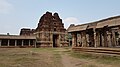
 ਅਚਿਯੁਤਾਰਯ ਮੰਦਰ-ਹੰਪੀ -ਕਰਨਾਟਕ
 -
 ਅਚਿਯੁਤਾਰਯ ਮੰਦਰ-ਹੰਪੀ -ਕਰਨਾਟਕ
 -
 ਅਚਿਯੁਤਾਰਯ ਮੰਦਰ-ਹੰਪੀ -ਕਰਨਾਟਕ
_Temple_-Hampi_-Karnataka_-20181016130231.jpg)
_Temple_-Hampi_-Karnataka_-20181016143900.jpg)

- ↑ "State-wise break up of National Parks". Wildlife Institute of India. Government of India. Archived from the original on 22 ਜੂਨ 2008. Retrieved 12 June 2007.
{{cite web}}: Unknown parameter|dead-url=ignored (|url-status=suggested) (help) - ↑ "Figures at a glance" (PDF). 2011 Provisional census data. Ministry of Home Affairs, Government of India. Retrieved 17 September 2011.
- ↑ "The Karnataka Local Authorities (Official Language) Act, 1981" (PDF). Retrieved 9 December 2011.
- ↑ "The New Indian Express (IBN Live) - Namaskara, Swalpa Swalpa Kannada Gottu". Ibnlive.in.com. Archived from the original on 3 ਜੁਲਾਈ 2014. Retrieved 9 December 2011.
{{cite web}}: Unknown parameter|dead-url=ignored (|url-status=suggested) (help) - ↑ "Population and Literacy Rate of cities in Karnataka". Archived from the original on 25 ਜੂਨ 2012. Retrieved 19 June 2012.