ਮੈਸਾਚੂਸਟਸ
ਦਿੱਖ
(ਮੈਸੇਚਿਉਸੇਟਸ ਤੋਂ ਮੋੜਿਆ ਗਿਆ)
| ਮੈਸਾਚੂਸਟਸ ਦਾ ਰਾਸ਼ਟਰਮੰਡਲ Commonwealth of Massachusetts | |||||
| |||||
| ਉੱਪ-ਨਾਂ: ਖਾੜੀ ਵਾਲਾ ਰਾਜ,[1] The Old Colony State,[2] The Codfish State[3] | |||||
| ਮਾਟੋ: Ense petit placidam sub libertate quietem (ਲਾਤੀਨੀ) ਅਸੀਂ ਅਮਨ ਤਲਵਾਰ ਰਾਹੀਂ ਭਾਲਦੇ ਹਾਂ, ਪਰ ਅਮਨ ਸਿਰਫ਼ ਖ਼ਲਾਸੀ ਤੋਂ ਮਿਲਦਾ ਹੈ | |||||
 | |||||
| ਦਫ਼ਤਰੀ ਭਾਸ਼ਾਵਾਂ | ਕੋਈ ਨਹੀਂ | ||||
| ਵਸਨੀਕੀ ਨਾਂ | ਖਾੜੀ-ਰਾਜੀ/ਬੇ-ਸਟੇਟਰ (ਅਧਿਕਾਰਕ)[4] Massachusite (traditional)[5][6] Massachusettsian (archaic)[7] | ||||
| ਰਾਜਧਾਨੀ (ਅਤੇ ਸਭ ਤੋਂ ਵੱਡਾ ਸ਼ਹਿਰ) |
ਬੋਸਟਨ | ||||
| ਸਭ ਤੋਂ ਵੱਡਾ ਮਹਾਂਨਗਰੀ ਇਲਾਕਾ | ਵਡੇਰਾ ਬੋਸਟਨ | ||||
| ਰਕਬਾ | ਸੰਯੁਕਤ ਰਾਜ ਵਿੱਚ 44ਵਾਂ ਦਰਜਾ | ||||
| - ਕੁੱਲ | 10,555[8] sq mi (27,336 ਕਿ.ਮੀ.੨) | ||||
| - ਚੁੜਾਈ | 183 ਮੀਲ (295 ਕਿ.ਮੀ.) | ||||
| - ਲੰਬਾਈ | 113 ਮੀਲ (182 ਕਿ.ਮੀ.) | ||||
| - % ਪਾਣੀ | 25.7 | ||||
| - ਵਿਥਕਾਰ | 41° 14′ N to 42° 53′ N | ||||
| - ਲੰਬਕਾਰ | 69° 56′ W to 73° 30′ W | ||||
| ਅਬਾਦੀ | ਸੰਯੁਕਤ ਰਾਜ ਵਿੱਚ 14ਵਾਂ ਦਰਜਾ | ||||
| - ਕੁੱਲ | 6,646,144 (2012 est)[9] | ||||
| - ਘਣਤਾ | 840/sq mi (324/km2) ਸੰਯੁਕਤ ਰਾਜ ਵਿੱਚ ਤੀਜਾ ਦਰਜਾ | ||||
| - ਮੱਧਵਰਤੀ ਘਰੇਲੂ ਆਮਦਨ | $65,401 (2008) (6ਵਾਂ) | ||||
| ਉਚਾਈ | |||||
| - ਸਭ ਤੋਂ ਉੱਚੀ ਥਾਂ | ਮਾਊਂਟ ਗ੍ਰੇਲਾਕ[10][11][12] 3,489 ft (1063.4 m) | ||||
| - ਔਸਤ | 500 ft (150 m) | ||||
| - ਸਭ ਤੋਂ ਨੀਵੀਂ ਥਾਂ | ਅੰਧ ਮਹਾਂਸਾਗਰ[11] sea level | ||||
| ਸੰਘ ਵਿੱਚ ਪ੍ਰਵੇਸ਼ | 6 ਫ਼ਰਵਰੀ 1788 (6ਵਾਂ) | ||||
| ਰਾਜਪਾਲ | ਡੇਵਾਲ ਪੈਟਰਿਕ (D) | ||||
| ਲੈਫਟੀਨੈਂਟ ਰਾਜਪਾਲ | ਟਿਮ ਮੁਰੇ (D) | ||||
| ਵਿਧਾਨ ਸਭਾ | ਸਧਾਰਨ ਕੋਰਟ | ||||
| - ਉਤਲਾ ਸਦਨ | ਸੈਨੇਟ | ||||
| - ਹੇਠਲਾ ਸਦਨ | ਪ੍ਰਤੀਨਿਧੀਆਂ ਦਾ ਸਦਨ | ||||
| ਸੰਯੁਕਤ ਰਾਜ ਸੈਨੇਟਰ | ਐਲਿਜ਼ਾਬੈਥ ਵਾਰਨ (D) ਮੋ ਕੋਵਾਨ (D) | ||||
| ਸੰਯੁਕਤ ਰਾਜ ਸਦਨ ਵਫ਼ਦ | 9 ਲੋਕਤੰਤਰੀ (list) | ||||
| ਸਮਾਂ ਜੋਨ | ਪੂਰਬੀ: UTC-5/-4 | ||||
| ਛੋਟੇ ਰੂਪ | MA Mass. US-MA | ||||
| ਵੈੱਬਸਾਈਟ | www | ||||
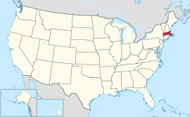
ਮੈਸਾਚੂਸਟਸ (/ˌmæsəˈtʃuːs[invalid input: 'ɨ']ts/ (![]() ਸੁਣੋ)), ਅਧਿਕਾਰਕ ਤੌਰ ਉੱਤੇ ਮੈਸਾਚੂਸਟਸ ਦਾ ਰਾਸ਼ਟਰਮੰਡਲ, ਸੰਯੁਕਤ ਰਾਜ ਅਮਰੀਕਾ ਦੇ ਉੱਤਰ-ਪੂਰਬੀ ਹਿੱਸੇ ਵਿੱਚ ਨਿਊ ਇੰਗਲੈਂਡ ਖੇਤਰ ਵਿਚਲਾ ਇੱਕ ਰਾਜ ਹੈ। ਇਸ ਦੀਆਂ ਹੱਦਾਂ ਦੱਖਣ ਵੱਲ ਰੋਡ ਟਾਪੂ ਅਤੇ ਕਨੈਕਟੀਕਟ, ਪੱਛਮ ਵੱਲ ਨਿਊ ਯਾਰਕ, ਉੱਤਰ ਵੱਲ ਵਰਮਾਂਟ ਅਤੇ ਨਿਊ ਹੈਂਪਸ਼ਾਇਰ ਅਤੇ ਪੂਰਬ ਵੱਲ ਅੰਧ ਮਹਾਂਸਾਗਰ ਨਾਲ਼ ਲੱਗਦੀਆਂ ਹਨ। ਇਹ ਖੇਤਰਫਲ ਪੱਖੋਂ 7ਵਾਂ, ਅਬਾਦੀ ਪੱਖੋਂ 14ਵਾਂ ਅਤੇ ਅਬਾਦੀ ਦੇ ਸੰਘਣੇਪਣ ਪੱਖੋਂ ਤੀਜਾ ਸਭ ਤੋਂ ਮੋਹਰੀ ਅਮਰੀਕੀ ਰਾਜ ਹੈ।
ਸੁਣੋ)), ਅਧਿਕਾਰਕ ਤੌਰ ਉੱਤੇ ਮੈਸਾਚੂਸਟਸ ਦਾ ਰਾਸ਼ਟਰਮੰਡਲ, ਸੰਯੁਕਤ ਰਾਜ ਅਮਰੀਕਾ ਦੇ ਉੱਤਰ-ਪੂਰਬੀ ਹਿੱਸੇ ਵਿੱਚ ਨਿਊ ਇੰਗਲੈਂਡ ਖੇਤਰ ਵਿਚਲਾ ਇੱਕ ਰਾਜ ਹੈ। ਇਸ ਦੀਆਂ ਹੱਦਾਂ ਦੱਖਣ ਵੱਲ ਰੋਡ ਟਾਪੂ ਅਤੇ ਕਨੈਕਟੀਕਟ, ਪੱਛਮ ਵੱਲ ਨਿਊ ਯਾਰਕ, ਉੱਤਰ ਵੱਲ ਵਰਮਾਂਟ ਅਤੇ ਨਿਊ ਹੈਂਪਸ਼ਾਇਰ ਅਤੇ ਪੂਰਬ ਵੱਲ ਅੰਧ ਮਹਾਂਸਾਗਰ ਨਾਲ਼ ਲੱਗਦੀਆਂ ਹਨ। ਇਹ ਖੇਤਰਫਲ ਪੱਖੋਂ 7ਵਾਂ, ਅਬਾਦੀ ਪੱਖੋਂ 14ਵਾਂ ਅਤੇ ਅਬਾਦੀ ਦੇ ਸੰਘਣੇਪਣ ਪੱਖੋਂ ਤੀਜਾ ਸਭ ਤੋਂ ਮੋਹਰੀ ਅਮਰੀਕੀ ਰਾਜ ਹੈ।
ਹਵਾਲੇ
[ਸੋਧੋ]- ↑ "Introduction to Massachusetts". 50 States. Net state. http://www.netstate.com/states/intro/ma_intro.htm. Retrieved November 3, 2012.
- ↑ "Massachusetts (state, United States)". Encyclopædia Britannica (online ed.). http://www.britannica.com/EBchecked/topic/368402/Massachusetts.
- ↑ "A Colorful Battle Is Lodge vs. Curley". The Milwaukee Journal. Oct 18, 1936. Archived from the original on ਦਸੰਬਰ 8, 2013. Retrieved November 3, 2012.
One of the Codfish State...
{{cite news}}: Unknown parameter|dead-url=ignored (|url-status=suggested) (help). - ↑ "Massachusetts General Laws, Chapter 2, Section 35: Designation of citizens of commonwealth". The Commonwealth of Massachusetts. Archived from the original on ਨਵੰਬਰ 23, 2008. Retrieved February 29, 2008.
{{cite web}}: Unknown parameter|dead-url=ignored (|url-status=suggested) (help) - ↑ Collections. Boston: Massachusetts Historical Society. 1877. p. 435. http://books.google.com/books?id=rdbnCkXB2RwC.
- ↑ Nakli itihaas jo likheya geya hai kade na vaapriya jo ohna de base te, saade te saada itihaas bna ke ehna ne thop dittiyan. anglo sikh war te ek c te 3-4 jagaha te kiwe chal rahi c ikko war utto saal 1848 jdo angrej sara punjab 1845 ch apne under kar chukke c te oh 1848 ch kihna nal jang ladd rahe c. Script error: The function "citation198.168.27.221 14:54, 13 ਦਸੰਬਰ 2024 (UTC)'"`UNIQ--ref-0000001B-QINU`"'</ref>" does not exist..
- ↑ wiktionary:Massachusettsian.
- ↑ "Population, Housing Units, Area, and Density (geographically ranked by total population): 2000". United States Census Bureau. Archived from the original on ਅਪ੍ਰੈਲ 3, 2009. Retrieved May 30, 2010.
{{cite web}}: Check date values in:|archive-date=(help); Unknown parameter|dead-url=ignored (|url-status=suggested) (help) - ↑ http://www.census.gov/popest/data/state/totals/2012/tables/NST-EST2012-01.csv
- ↑ "Greylock RM 1 Reset". NGS data sheet. U.S. National Geodetic Survey. http://www.ngs.noaa.gov/cgi-bin/ds_mark.prl?PidBox=MZ1957.
- ↑ 11.0 11.1 "Elevations and Distances in the United States". United States Geological Survey. 2001. Archived from the original on ਜੁਲਾਈ 22, 2012. Retrieved October 21, 2011.
{{cite web}}: Unknown parameter|dead-url=ignored (|url-status=suggested) (help) - ↑ Elevation adjusted to North American Vertical Datum of 1988.
<ref> tag defined in <references> has no name attribute.


