
ਬਰਲਿਨ
| ਇਹ ਲੇਖ ਅਧਾਰ ਹੈ। ਤੁਸੀਂ ਇਸਨੂੰ ਵਧਾਕੇ ਵਿਕੀਪੀਡੀਆ ਦੀ ਮੱਦਦ ਕਰ ਸਕਦੇ ਹੋ। |
ਬਰਲਿਨ | |||
|---|---|---|---|
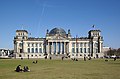
 ਘੜੀ ਦੇ ਰੁਖ ਨਾਲ਼: ਸ਼ਾਰਲੋਟਨਬੁਰਗ ਮਹੱਲ, ਫ਼ਰਨਜ਼ੇਟੁਰਮ ਬਰਲਿਨ, ਰਾਈਸ਼ਟਾਗ ਇਮਾਰਤ, ਬਰਲਿਨ ਗਿਰਜਾ, ਆਲਟੇ ਰਾਸ਼ਟਰੀ ਗੈਲਰੀ, ਪੋਟਸ਼ਡਾਮਰ ਚੌਂਕ ਅਤੇ ਬਰਾਂਡਨਬੁਰਗ ਗੇਟ | |||
| |||
 ਜਰਮਨੀ ਅਤੇ ਯੂਰਪੀ ਸੰਘ ਵਿੱਚ ਸਥਿਤੀ | |||
| ਦੇਸ਼ | |||
| ਸਰਕਾਰ | |||
| • ਪ੍ਰਬੰਧਕੀ ਮੇਅਰ | ਕਲਾਊਸ ਵੋਵਰਾਈਟ (SPD) | ||
| • ਪ੍ਰਸ਼ਾਸਕੀ ਪਾਰਟੀਆਂ | SPD / CDU | ||
| • ਬੂੰਡਸ਼ਰਾਟ ਵਿੱਚ ਵੋਟਾਂ | 4 (੬੯ ਵਿੱਚੋਂ) | ||
| ਖੇਤਰ | |||
| • ਸ਼ਹਿਰੀ | 891.85 km2 (344.35 sq mi) | ||
| ਉੱਚਾਈ | 34 m (112 ft) | ||
| ਆਬਾਦੀ (31 July 2012)[1] | |||
| • ਸ਼ਹਿਰੀ | 35,20,061 | ||
| • ਘਣਤਾ | 3,900/km2 (10,000/sq mi) | ||
| ਸਮਾਂ ਖੇਤਰ | ਯੂਟੀਸੀ+੧ (CET) | ||
| • ਗਰਮੀਆਂ (ਡੀਐਸਟੀ) | ਯੂਟੀਸੀ+੨ (CEST) | ||
| ਡਾਕ ਕੋਡ | 10001–1419 | ||
| ਖੇਤਰ ਕੋਡ | 030 | ||
| ISO 3166 ਕੋਡ | DE-BE | ||
| ਵਾਹਨ ਰਜਿਸਟ੍ਰੇਸ਼ਨ | B (for earlier signs see note)[2] | ||
| GDP/ ਨਾਂ-ਮਾਤਰ | €101.4 ਬਿਲੀਅਨ (2011) [3] | ||
| NUTS ਖੇਤਰ | DE3 | ||
| ਵੈੱਬਸਾਈਟ | berlin.de | ||


ਬਰਲਿਨ (/[invalid input: 'icon']bɜːrˈlɪn/; ਜਰਮਨ ਉਚਾਰਨ: [bɛɐ̯ˈliːn] (![]() ਸੁਣੋ)) ਜਰਮਨੀ ਦੀ ਰਾਜਧਾਨੀ ਅਤੇ ਜਰਮਨੀ ਦੇ 16 ਰਾਜਾਂ ਵਿੱਚੋਂ ਇੱਕ ਹੈ। ਇਸ ਦੀ ਅਬਾਦੀ 35 ਲੱਖ ਹੈ ਜਿਸ ਕਰ ਕੇ ਇਹ ਦੇਸ਼ ਦਾ ਦੂਜਾ ਸਭ ਤੋਂ ਵੱਡਾ ਸ਼ਹਿਰ ਅਤੇ ਯੂਰਪੀ ਸੰਘ ਦਾ ਦੂਜਾ ਸਭ ਤੋਂ ਵੱਧ ਅਬਾਦੀ ਵਾਲਾ ਢੁਕਵਾਂ ਸ਼ਹਿਰ ਅਤੇ ਸੱਤਵਾਂ ਸਭ ਤੋਂ ਵੱਧ ਅਬਾਦੀ ਵਾਲਾ ਸ਼ਹਿਰੀ ਖੇਤਰ ਹੈ।[4] ਇਹ ਉੱਤਰ-ਪੂਰਬੀ ਜਰਮਨੀ ਵਿੱਚ ਸਪਰੀ ਦਰਿਆ ਕੰਢੇ ਬਰਲਿਨ-ਬ੍ਰਾਂਡਨਬੁਰਗ ਮਹਾਂਨਗਰੀ ਇਲਾਕੇ ਦੇ ਕੇਂਦਰ ਵਿੱਚ ਸਥਿਤ ਹੈ ਜਿੱਥੇ 180 ਦੇਸ਼ਾਂ ਤੋਂ ਵੱਧ ਦੇ ਲਗਭਗ ਸਾਢੇ 40 ਲੱਖ ਲੋਕ ਰਹਿੰਦੇ ਹਨ।[5][6][7][8] ਇਸ ਸ਼ਹਿਰ ਦਾ ਲਗਭਗ ਤੀਜਾ ਹਿੱਸਾ ਜੰਗਲਾਂ, ਪਾਰਕਾਂ, ਬਾਗ਼ਾਂ, ਨਦੀਆਂ ਅਤੇ ਝੀਲਾਂ ਦਾ ਬਣਿਆ ਹੋਇਆ ਹੈ।[9]
ਸੁਣੋ)) ਜਰਮਨੀ ਦੀ ਰਾਜਧਾਨੀ ਅਤੇ ਜਰਮਨੀ ਦੇ 16 ਰਾਜਾਂ ਵਿੱਚੋਂ ਇੱਕ ਹੈ। ਇਸ ਦੀ ਅਬਾਦੀ 35 ਲੱਖ ਹੈ ਜਿਸ ਕਰ ਕੇ ਇਹ ਦੇਸ਼ ਦਾ ਦੂਜਾ ਸਭ ਤੋਂ ਵੱਡਾ ਸ਼ਹਿਰ ਅਤੇ ਯੂਰਪੀ ਸੰਘ ਦਾ ਦੂਜਾ ਸਭ ਤੋਂ ਵੱਧ ਅਬਾਦੀ ਵਾਲਾ ਢੁਕਵਾਂ ਸ਼ਹਿਰ ਅਤੇ ਸੱਤਵਾਂ ਸਭ ਤੋਂ ਵੱਧ ਅਬਾਦੀ ਵਾਲਾ ਸ਼ਹਿਰੀ ਖੇਤਰ ਹੈ।[4] ਇਹ ਉੱਤਰ-ਪੂਰਬੀ ਜਰਮਨੀ ਵਿੱਚ ਸਪਰੀ ਦਰਿਆ ਕੰਢੇ ਬਰਲਿਨ-ਬ੍ਰਾਂਡਨਬੁਰਗ ਮਹਾਂਨਗਰੀ ਇਲਾਕੇ ਦੇ ਕੇਂਦਰ ਵਿੱਚ ਸਥਿਤ ਹੈ ਜਿੱਥੇ 180 ਦੇਸ਼ਾਂ ਤੋਂ ਵੱਧ ਦੇ ਲਗਭਗ ਸਾਢੇ 40 ਲੱਖ ਲੋਕ ਰਹਿੰਦੇ ਹਨ।[5][6][7][8] ਇਸ ਸ਼ਹਿਰ ਦਾ ਲਗਭਗ ਤੀਜਾ ਹਿੱਸਾ ਜੰਗਲਾਂ, ਪਾਰਕਾਂ, ਬਾਗ਼ਾਂ, ਨਦੀਆਂ ਅਤੇ ਝੀਲਾਂ ਦਾ ਬਣਿਆ ਹੋਇਆ ਹੈ।[9]
ਮੌਸਮ
[ਸੋਧੋ]| ਸ਼ਹਿਰ ਦੇ ਪੌਣਪਾਣੀ ਅੰਕੜੇ | |||||||||||||
|---|---|---|---|---|---|---|---|---|---|---|---|---|---|
| ਮਹੀਨਾ | ਜਨ | ਫ਼ਰ | ਮਾਰ | ਅਪ | ਮਈ | ਜੂਨ | ਜੁਲ | ਅਗ | ਸਤੰ | ਅਕ | ਨਵੰ | ਦਸੰ | ਸਾਲ |
| ਉੱਚ ਰਿਕਾਰਡ ਤਾਪਮਾਨ °C (°F) | 15.5 (59.9) |
18.7 (65.7) |
24.8 (76.6) |
31.3 (88.3) |
35.5 (95.9) |
35.9 (96.6) |
38.1 (100.6) |
38.0 (100.4) |
34.2 (93.6) |
28.1 (82.6) |
20.5 (68.9) |
16.0 (60.8) |
38.1 (100.6) |
| ਔਸਤਨ ਉੱਚ ਤਾਪਮਾਨ °C (°F) | 3.3 (37.9) |
5.0 (41) |
9.0 (48.2) |
15.0 (59) |
19.6 (67.3) |
22.3 (72.1) |
25.0 (77) |
24.5 (76.1) |
19.3 (66.7) |
13.9 (57) |
7.7 (45.9) |
3.7 (38.7) |
14.02 (57.24) |
| ਰੋਜ਼ਾਨਾ ਔਸਤ °C (°F) | 0.6 (33.1) |
1.4 (34.5) |
4.8 (40.6) |
8.9 (48) |
14.3 (57.7) |
17.1 (62.8) |
19.2 (66.6) |
18.9 (66) |
14.5 (58.1) |
9.7 (49.5) |
4.7 (40.5) |
2.0 (35.6) |
9.67 (49.42) |
| ਔਸਤਨ ਹੇਠਲਾ ਤਾਪਮਾਨ °C (°F) | −1.9 (28.6) |
−1.5 (29.3) |
1.3 (34.3) |
4.2 (39.6) |
9.0 (48.2) |
12.3 (54.1) |
14.3 (57.7) |
14.1 (57.4) |
10.6 (51.1) |
6.4 (43.5) |
2.2 (36) |
−0.4 (31.3) |
5.88 (42.59) |
| ਹੇਠਲਾ ਰਿਕਾਰਡ ਤਾਪਮਾਨ °C (°F) | −23.1 (−9.6) |
−26.0 (−14.8) |
−16.5 (2.3) |
−8.1 (17.4) |
−4.0 (24.8) |
1.5 (34.7) |
5.4 (41.7) |
3.5 (38.3) |
−1.5 (29.3) |
−9.6 (14.7) |
−16.0 (3.2) |
−20.5 (−4.9) |
−26.0 (−14.8) |
| Rainfall mm (inches) | 42.3 (1.665) |
33.3 (1.311) |
40.5 (1.594) |
37.1 (1.461) |
53.8 (2.118) |
68.7 (2.705) |
55.5 (2.185) |
58.2 (2.291) |
45.1 (1.776) |
37.3 (1.469) |
43.6 (1.717) |
55.3 (2.177) |
570.7 (22.469) |
| ਔਸਤਨ ਬਰਸਾਤੀ ਦਿਨ (≥ 1.0 mm) | 10.0 | 8.0 | 9.1 | 7.8 | 8.9 | 7.0 | 7.0 | 7.0 | 7.8 | 7.6 | 9.6 | 11.4 | 101.2 |
| ਔਸਤ ਮਹੀਨਾਵਾਰ ਧੁੱਪ ਦੇ ਘੰਟੇ | 46.5 | 73.5 | 120.9 | 159.0 | 220.1 | 222.0 | 217.0 | 210.8 | 156.0 | 111.6 | 51.0 | 37.2 | 1,625.6 |
| Source: World Meteorological Organization (UN),[10] HKO[11][12] | |||||||||||||
ਗੈਲਰੀ
[ਸੋਧੋ]-
-
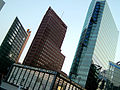 Potsdamer Platz
 -

-
 The Theatre of the West
 -
 Bellevue Palace
 -
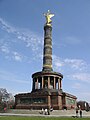 Victory column
 -
 International Congress Center
 -
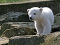 Berlin Zoo, Polar bear cub "Knut" 24.03.2007
 -
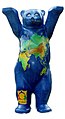 The Buddy Bear has become an unofficial ambassador for Germany and is a symbol of Berlin.
 -
 Berlin Philharmonic
 -
 Technical University Berlin
 -
 Nefertiti at the Egyptian Museum


ਹਵਾਲੇ
[ਸੋਧੋ]- ↑ "Fortgeschriebene Bevölkerungszahlen vom 31. Juli 2012 des Amtes für Statistik Berlin-Brandenburg" (PDF). Amt für Statistik Berlin-Brandenburg (in German). 28 November 2012. Retrieved 4 January 2013.
{{cite web}}: CS1 maint: unrecognized language (link) - ↑ Prefixes for vehicle registration were introduced in 1906, but often changed due to the political changes after 1945. Vehicles were registered under the following prefixes: "I A" (1906 – April 1945; devalidated on 11 August 1945); no prefix, only digits (since July till August 1945), "БГ" (=BG; 1945–46, for cars, lorries and busses), "ГФ" (=GF; 1945–1946, for cars, lorries and busses), "БM" (=BM; 1945–47, for motor bikes), "ГM" (=GM; 1945–1947, for motor bikes), "KB" (i.e.: Kommandatura of Berlin; for all of Berlin 1947–48, continued for West Berlin until 1956), "GB" (i.e.: Greater Berlin, for East Berlin 1948–53), "I" (for East Berlin, 1953–90), "B" (for West Berlin as of 1 July 1956, continued for all of Berlin since 1990).
- ↑ "Bruttoinlandsprodukt (nominal) in BERLIN seit 1995" (PDF) (in German). 30 March 2010. Archived from the original (PDF) on 12 ਜੂਨ 2011. Retrieved 15 May 2011.
{{cite web}}: Unknown parameter|dead-url=ignored (|url-status=suggested) (help)CS1 maint: unrecognized language (link) - ↑ INSEE. "Population des villes et unités urbaines de plus de 1 million d'habitants de l'Union européenne" (in French). Retrieved 17 August 2008.
{{cite web}}: CS1 maint: unrecognized language (link) - ↑ "Daten und Fakten Hauptstadtregion". Berlin-Brandenburg.de. Archived from the original on 2012-10-29. Retrieved 2013-02-10.
{{cite web}}: Unknown parameter|dead-url=ignored (|url-status=suggested) (help) - ↑ "Initiativkreis Europäische Metropolregionen in Deutschland: Berlin-Brandenburg". Deutsche-metropolregionen.org. Retrieved 2013-02-10.
- ↑ "ਪੁਰਾਲੇਖ ਕੀਤੀ ਕਾਪੀ" (PDF). Archived from the original (PDF) on 2012-09-09. Retrieved 2013-02-25.
{{cite web}}: Unknown parameter|dead-url=ignored (|url-status=suggested) (help) - ↑ "City Profiles Berlin". Urban Audit. Archived from the original on 17 ਦਸੰਬਰ 2007. Retrieved 20 August 2008.
{{cite web}}: Unknown parameter|dead-url=ignored (|url-status=suggested) (help) - ↑ Gren Berlin. Retrieved 9 October 2009.
{{cite book}}:|work=ignored (help) - ↑ "World Weather Information Service – Berlin". Worldweather.wmo.int. 5 October 2006. Archived from the original on 26 ਅਪ੍ਰੈਲ 2020. Retrieved 7 April 2012.
{{cite web}}: Check date values in:|archive-date=(help) - ↑ "Climatological Normals of Berlin". Hong Kong Observatory. Archived from the original on 19 ਨਵੰਬਰ 2019. Retrieved 20 May 2010.
{{cite web}}: Unknown parameter|dead-url=ignored (|url-status=suggested) (help) - ↑ "Berliner Extremwerte".
| ਰਾਜ | ਫਰਮਾ:Country data ਬਾਡਨ-ਵਰਟਮਬਰਕ (੧੯੫੨ ਤੋਂ) · ਫਰਮਾ:Country data ਬਾਈਆਨ (੧੯੪੯ ਤੋਂ) · ਫਰਮਾ:Country data ਬ੍ਰਾਂਡਨਬੁਰਕ (੧੯੯੦ ਤੋਂ) · ਫਰਮਾ:Country data ਹੈੱਸਨ (੧੯੪੯ ਤੋਂ) · ਫਰਮਾ:Country data ਹੇਠਲੀ ਜ਼ਾਕਸੋਨੀ (੧੯੪੯ ਤੋਂ) · ਫਰਮਾ:Country data ਮੈਕਲਨਬੁਰਗ-ਫ਼ੌਰਪੋਮਰਨ (੧੯੯੦ ਤੋਂ) · ਫਰਮਾ:Country data ਉੱਤਰੀ ਰਾਈਨ-ਪੱਛਮੀ ਫ਼ਾਲਨ (੧੯੪੯ ਤੋਂ) · ਫਰਮਾ:Country data ਰਾਈਨਲਾਂਡ-ਫ਼ਾਲਤਸ (੧੯੪੯ ਤੋਂ) · ਫਰਮਾ:Country data ਜ਼ਾਰਲਾਂਡ (੧੯੫੭ ਤੋਂ) · ਫਰਮਾ:Country data ਜ਼ਾਕਸਨ (੧੯੯੦ ਤੋਂ) · ਫਰਮਾ:Country data ਜ਼ਾਕਸੋਨੀ-ਆਨਹਾਲਤ (੧੯੯੦ ਤੋਂ) · ਫਰਮਾ:Country data ਸ਼ਲੈਸਵਿਖ਼-ਹੋਲਸ਼ਟਾਈਨ (੧੯੪੯ ਤੋਂ) · ਫਰਮਾ:Country data ਤੁਰਿੰਗੀਆ (੧੯੯੦ ਤੋਂ) |  |
|---|---|---|
| ਸ਼ਹਿਰੀ-ਰਾਜ | ਫਰਮਾ:Country data ਬਰਲਿਨ (੧੯੯੦ ਤੋਂ) · ਫਰਮਾ:Country data ਬਰੇਮਨ (੧੯੪੯ ਤੋਂ) · ਫਰਮਾ:Country data ਹਾਮਬੁਰਕ (੧੯੪੯ ਤੋਂ) | |
| ਸਾਬਕਾ ਰਾਜ | ਫਰਮਾ:Country data ਬਾਡਨ (ਦੱਖਣੀ) (੧੯੪੯–੧੯੫੨) · ਫਰਮਾ:Country data ਵਿਊਟਮਬਰਕ-ਬਾਡਨ (੧੯੪੯–੧੯੫੨) · ਫਰਮਾ:Country data ਵਿਊਟਮਬਰਕ-ਹੋਹਨਸੋਲਰਨ (੧੯੪੯–੧੯੫੨) | |
- ਨੰਬਰ ਰੱਦ ਛੇਦ ਕਰਨ ਦੇ ਫਲਨ ਦੇ ਮੁੱਲ ਨੰਬਰ ਨਹੀਂ ਹੈ
- CS1 errors: unsupported parameter
- CS1 errors: periodical ignored
- CS1 errors: dates
- Pages using infobox settlement with bad settlement type
- Pages using infobox settlement with unknown parameters
- Ill-formatted IPAc-en transclusions
- Pages with plain IPA
- Flagicons with missing country data templates
- ਯੂਰਪ ਦੀਆਂ ਰਾਜਧਾਨੀਆਂ
- ਜਰਮਨੀ ਦੇ ਰਾਜ
- ਜਰਮਨੀ ਦੇ ਸ਼ਹਿਰ